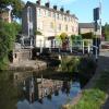
Brewery Swing Bridge No 177

The key is used to operate the lights and barrier and to unlock the bridge. The bridge is then swung manually.
Brewery Lane, Skipton BD23 1DF, United Kingdom

Brewery Swing Bridge No 177
is a minor waterways place
on the Leeds and Liverpool Canal (Main Line - Wigan to Leeds) between
Salterforth Bridge No 151 (Salterforth village 200 yards northeast) (14 miles and ½ furlongs
and 15 locks
to the west) and
Skipton Junction (Junction of Springs Branch with Leeds and Liverpool Canal Main Line) (1 furlong
to the east).
The nearest place in the direction of Salterforth Bridge No 151 is Gawflat Swing Bridge No 176;
1¼ furlongs
away.
The nearest place in the direction of Skipton Junction is Eller Beck Aqueduct No 42 (The aqueduct crosses the Eller Beck, a tributary of the River Aire.);
¼ furlongs
away.
There is access (suitable for wheels) to the towpath here.
Mooring here is good (a nice place to moor).
Facilities: water point.
There is a swing bridge here. The bridge requires a BW key to operate it.
| Gawber Hill Winding Hole | 1 mile, 4½ furlongs | |
| Niffany Swing Bridge No 175 | 1 mile, 1 furlong | |
| Skipton Bypass Bridge No 175A | 7¼ furlongs | |
| Gawflat Pipe Bridge | 2 furlongs | |
| Gawflat Swing Bridge No 176 | 1¼ furlongs | |
| Brewery Swing Bridge No 177 | ||
| Eller Beck Aqueduct No 42 | ¼ furlongs | |
| Skipton Junction | 1 furlong | |
| Belmont Bridge No 178 | 1½ furlongs | |
| Waller Hill Aqueduct No 43 | 1¾ furlongs | |
| Skipton Visitor Moorings | 2 furlongs | |
Amenities here
Amenities nearby at Gawflat Swing Bridge No 176
Amenities nearby at Eller Beck Aqueduct No 42
There are no links to external websites from here.
Why not log in and add some (select "External websites" from the menu (sometimes this is under "Edit"))?
Mouseover for more information or show routes to facility
Nearest water point
The nearest water point is here. Others are at:
In the direction of Leeds Bridge
Skipton Visitor Moorings — 2 furlongs away
On this waterway in the direction of Leeds Bridge
ABC Swing Footbridge — 12 miles, 7 furlongs away
On this waterway in the direction of Leeds Bridge
Bingley Services — 13 miles, 1¼ furlongs away
On this waterway in the direction of Leeds Bridge
In the direction of Wigan Junction
Gawflat Swing Bridge No 176 — 1¼ furlongs away
On this waterway in the direction of Wigan Junction
Gargrave Services — 4 miles, 7¾ furlongs and 3 locks away
On this waterway in the direction of Wigan Junction
Priest Holme Water Point — 6 miles, 1¾ furlongs and 6 locks away
On this waterway in the direction of Wigan Junction
East Marton Visitor Moorings — 8 miles, 7½ furlongs and 12 locks away
On this waterway in the direction of Wigan Junction
Greenberfield Services — 11 miles, 6½ furlongs and 15 locks away
On this waterway in the direction of Wigan Junction
Lower Park Marina — 13 miles, 3 furlongs and 15 locks away
On this waterway in the direction of Wigan Junction
Salterforth Bridge No 151 — 14 miles, ½ furlongs and 15 locks away
On this waterway in the direction of Wigan Junction
Foulridge Wharf — 15 miles, 6 furlongs and 15 locks away
On this waterway in the direction of Wigan Junction
Barrowford Top Lock No 45 — 17 miles, 5¼ furlongs and 15 locks away
On this waterway in the direction of Wigan JunctionNearest rubbish disposal
In the direction of Leeds Bridge
Skipton Visitor Moorings — 2 furlongs away
On this waterway in the direction of Leeds Bridge
Bingley Services — 13 miles, 1¼ furlongs away
On this waterway in the direction of Leeds Bridge
In the direction of Wigan Junction
Gargrave Services — 4 miles, 7¾ furlongs and 3 locks away
On this waterway in the direction of Wigan Junction
Greenberfield Services — 11 miles, 6½ furlongs and 15 locks away
On this waterway in the direction of Wigan Junction
Lower Park Marina — 13 miles, 3 furlongs and 15 locks away
On this waterway in the direction of Wigan Junction
Salterforth Bridge No 151 — 14 miles, ½ furlongs and 15 locks away
On this waterway in the direction of Wigan Junction
Foulridge Wharf — 15 miles, 6 furlongs and 15 locks away
On this waterway in the direction of Wigan Junction
Barrowford Lock No 47 — 17 miles, 6¼ furlongs and 17 locks away
On this waterway in the direction of Wigan JunctionNearest chemical toilet disposal
In the direction of Leeds Bridge
Skipton Visitor Moorings — 2 furlongs away
On this waterway in the direction of Leeds Bridge
Bingley Services — 13 miles, 1¼ furlongs away
On this waterway in the direction of Leeds Bridge
In the direction of Wigan Junction
Gargrave Services — 4 miles, 7¾ furlongs and 3 locks away
On this waterway in the direction of Wigan Junction
Greenberfield Services — 11 miles, 6½ furlongs and 15 locks away
On this waterway in the direction of Wigan Junction
Lower Park Marina — 13 miles, 3 furlongs and 15 locks away
On this waterway in the direction of Wigan Junction
Salterforth Bridge No 151 — 14 miles, ½ furlongs and 15 locks away
On this waterway in the direction of Wigan Junction
Foulridge Wharf — 15 miles, 6 furlongs and 15 locks away
On this waterway in the direction of Wigan Junction
Barrowford Top Lock No 45 — 17 miles, 5¼ furlongs and 15 locks away
On this waterway in the direction of Wigan JunctionNearest place to turn
In the direction of Leeds Bridge
Skipton Junction — 1 furlong away
On this waterway in the direction of Leeds Bridge
Farnhill Bridge Winding Hole — 3 miles, 7¼ furlongs away
On this waterway in the direction of Leeds Bridge
Kildwick Winding Hole — 5 miles, ¾ furlongs away
On this waterway in the direction of Leeds Bridge
Booth's Swing Bridge Winding Hole — 9 miles, 1¼ furlongs away
On this waterway in the direction of Leeds Bridge
Stockbridge Winding Hole — 10 miles, 3¼ furlongs away
On this waterway in the direction of Leeds Bridge
Crossflats Winding Hole — 12 miles, 6¾ furlongs away
On this waterway in the direction of Leeds Bridge
Bingley Winding Hole — 13 miles, 4¾ furlongs and 8 locks away
On this waterway in the direction of Leeds Bridge
Park Road Winding Hole — 13 miles, 6¾ furlongs and 8 locks away
On this waterway in the direction of Leeds Bridge
Primrose Lane Winding Hole — 14 miles, 5 furlongs and 8 locks away
On this waterway in the direction of Leeds Bridge
Hirst Mill Winding Hole — 15 miles, 3½ furlongs and 10 locks away
On this waterway in the direction of Leeds Bridge
Ashley Mill Basin — 16 miles, 4 furlongs and 11 locks away
On this waterway in the direction of Leeds Bridge
In the direction of Wigan Junction
Gawber Hill Winding Hole — 1 mile, 4½ furlongs away
On this waterway in the direction of Wigan Junction
Highgate Winding Hole No 2 — 3 miles, 6 furlongs away
On this waterway in the direction of Wigan Junction
Highgate Winding Hole No 1 — 3 miles, 7¾ furlongs away
On this waterway in the direction of Wigan Junction
Ray Bridge Winding Hole — 4 miles, 3¾ furlongs and 1 lock away
On this waterway in the direction of Wigan Junction
Gargrave Winding Hole — 5 miles, ¼ furlongs and 3 locks away
On this waterway in the direction of Wigan Junction
Nuttleber Dyke Winding Hole — 7 miles, 3¼ furlongs and 12 locks away
On this waterway in the direction of Wigan Junction
South Field Bridge Winding Hole — 9 miles, 2¼ furlongs and 12 locks away
On this waterway in the direction of Wigan Junction
Nuttercote Winding Hole — 11 miles, ½ furlongs and 12 locks away
On this waterway in the direction of Wigan Junction
Coates Lane Winding Hole — 12 miles, ¼ furlongs and 15 locks away
On this waterway in the direction of Wigan JunctionNearest boatyard pump-out
In the direction of Leeds Bridge
Pennine Cruisers Wharf — 1¼ furlongs away
Travel to Skipton Junction, then on the Leeds and Liverpool Canal (Springs Branch) to Pennine Cruisers Wharf
Snaygill Boatyard — 1 mile, 6¾ furlongs away
On this waterway in the direction of Leeds Bridge
Silsden Wharf — 6 miles, 7¼ furlongs away
On this waterway in the direction of Leeds Bridge
Hainsworth’s Boatyard — 12 miles, 7½ furlongs away
On this waterway in the direction of Leeds Bridge
Shipley Wharf — 16 miles, 5 furlongs and 11 locks away
On this waterway in the direction of Leeds Bridge
In the direction of Wigan Junction
Lower Park Marina — 13 miles, 3 furlongs and 15 locks away
On this waterway in the direction of Wigan JunctionNo information
CanalPlan has no information on any of the following facilities within range:self-operated pump-out
Direction of TV transmitter (From Wolfbane Cybernetic)
There is no page on Wikipedia called “Brewery Swing Bridge”
Wikipedia pages that might relate to Brewery Swing Bridge
[Barton Swing Aqueduct]
Andrew Handyside and Company of Derby, the swing bridge opened in 1894 and remains in regular use. The Barton Swing Aqueduct is a direct replacement for the
[Grosse Ile Toll Bridge]
The Grosse Ile Toll Bridge is a swing bridge that crosses the Trenton Channel of the Detroit River connecting Grosse Ile Township, Michigan to the mainland
[Barton Road Swing Bridge]
Barton Road Swing Bridge (or Barton Road Bridge) is a swing bridge for road traffic in Greater Manchester that crosses the Manchester Ship Canal between
[Leeds and Liverpool Canal]
Granary Wharf, Leeds city centre Armley Pool Kirkstall Bramley Apperley Bridge Shipley Saltaire Bingley Keighley Silsden Skipton Gargrave Barnoldswick
[Alloa Railway]
8 km) north of Alloa Junction. It was 3 miles (4.8 km) long, with a swing bridge over River Forth, and terminated at a piece of vacant ground in the town
[Media City Footbridge]
Footbridge is a swing-mechanism footbridge over the Manchester Ship Canal near MediaCityUK. It is an asymmetric cable-stayed swing bridge and was completed
[Mortlake]
including the former brewery, unlike the embankment style roads along other London banks such as in Barnes until Barnes Bridge. The two large pubs at
[Fulham]
a brewery and residential development, 'Rosa' - and 'Hermitage Cottages', and several roads, notably, the Lillie Road connecting the canal bridge, (Lillie
[List of cover versions of Beatles songs]
2007 This Strange Convention Marillion "Let It Be" 2000 A Piss-Up in a Brewery Marmalade "Ob-La-Di, Ob-La-Da" 1968 single Maroon 5 "If I Fell" 2004 1
[Burton upon Trent]
Burton Bridge Brewery is based in Bridge Street, with six pubs in and around Burton. It produces a number of traditional beers including Bridge Bitter
Results of Google Search
File:Brewery swing bridge 177, Leeds and Liverpool Canal, Skipton ...Jan 13, 1990 ... File:Brewery swing bridge 177, Leeds and Liverpool Canal, Skipton - geograph. org.uk - 676095.jpg. Read in ... No higher resolution available.
Apr 26, 2018 ... File:Brewery Swing Bridge 177, Leeds and Liverpool Canal - geograph.org.uk - 695757.jpg. Read in another ... No higher resolution available.
Our Taproom and Brewery is located in historic downtown River Falls, walking distance from the historic landmark Swinging Bridge which spans the south fork of ...
Jul 18, 2006 ... The most easterly of four swing bridges lying immediately to the west of Skipton on the Leeds and Liverpool canal. This bridge, seen here from ...
Craven Towpath Improvements - Bridge 177, Brewery Swing Bridge to Bridge ... Type: Towpath Closure. Reason: 3rd Party Works. Is the towpath closed? No ...
21 reviews of Swinging Bridge Brewing Company "Excellent!! Service was great even though it was packed, apps were good & the beer? AMAZING. CAn't wait ...
Swing Bridge IPA by Steady Habit Brewing Company is a IPA - American which has a rating of 3.6 out of 5, with 688 ratings and reviews on Untappd.
Swinging Bridge will serve great craft beer while we wait for our Brewpub License to be processed! Keep checking back for updates on our brewing progress!

![Brewery Swing Bridge. The Brewery Swing Bridge over the Leeds & Liverpool Canal. Compare with the view in 1990 [[695757]]. by Gerald England – 13 June 2008](https://s3.geograph.org.uk/photos/84/32/843287_d7c97ef8_120x120.jpg)
![Brook Street canal bridge, Skipton. A swing bridge. See also [[1395345]]. by Stephen Craven – 20 April 2019](https://s2.geograph.org.uk/geophotos/06/13/95/6139522_6af942e3_120x120.jpg)


![Brook Street Bridge, Skipton, open to canal traffic. The swing bridge [[1395345]] was open to let a couple of narrowboats through. by Stephen Craven – 11 September 2016](https://s1.geograph.org.uk/geophotos/05/11/64/5116497_fc282594_120x120.jpg)

![Brook Street swing bridge. For a view of this bridge over the Leeds & Liverpool Canal from the road see [[843287]]. by Stephen Craven – 21 June 2009](https://s1.geograph.org.uk/geophotos/01/39/53/1395345_dd329e3d_120x120.jpg)


![Skipton features [11]. This swing bridge carries Brewery Lane over the Leeds and Liverpool Canal.Skipton is a market town in North Yorkshire, some 27 miles northwest of Leeds. On the southern edge of the Yorkshire Dales National Park, it is now an important tourist destination. The town expanded after the construction of Skipton Castle in the 11th century. The Leeds and Liverpool Canal runs through the town and the River Aire flows just to the southwest. The name Skipton means 'sheep-town'. by Michael Dibb – 25 June 2021](https://s0.geograph.org.uk/geophotos/07/01/16/7011676_4efe20d0_120x120.jpg)


![Converted mill, Brewery Lane. Photo taken from canal towpath. The building has an OS benchmark [[3471870]] on the near corner on the towpath face by Roger Templeman – 29 April 2013](https://s2.geograph.org.uk/geophotos/03/47/18/3471886_9d485cb0_120x120.jpg)

![View west along Leeds & Liverpool Canal towards Brewery Lane swing bridge. The canal is on an aqueduct over Eller Beck at this point. There is a canal milepost [[7779245]] in the left foreground by Roger Templeman – 10 April 2024](https://s3.geograph.org.uk/geophotos/07/77/93/7779363_9f6591ac_120x120.jpg)
![Barriers being lowered at Brook Street bridge. The level-crossing style barriers and lights are manually operated by boaters. See also [[6139522]]. by Stephen Craven – 28 August 2023](https://s0.geograph.org.uk/geophotos/07/58/59/7585988_08dcf66b_120x120.jpg)


![Eller Beck, Skipton, Yorkshire. A tributary of the River Aire. See also [[704432]] by Dr Neil Clifton – 21 April 2006](https://s3.geograph.org.uk/photos/87/30/873035_8c244ff3_120x120.jpg)
![Brook Street - demolition site. The lower end of Brook Street below the bridge [[1395345]] was closed off because of demolition of adjacent mill buildings. by Stephen Craven – 21 June 2009](https://s1.geograph.org.uk/geophotos/01/39/53/1395353_51205188_120x120.jpg)



![Canal overflow . This overflow takes surplus water from the Leeds and Liverpool Canal in Skipton down to the Eller Beck below (a tributary of the River Aire). For context see [[3736008]]. by Stephen Craven – 30 June 2013](https://s3.geograph.org.uk/geophotos/03/73/60/3736011_38ee29b5_120x120.jpg)