CanalPlanAC

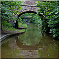
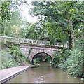
Newport Road Bridge No 45

 
Knighton
Knighton ST20 0QJ, United Kingdom
 
Information about the place
Newport Road Bridge No 45 is near or in the village of Knighton and is on the Shropshire Union Canal (Birmingham and Liverpool Junction Canal - Main Line) between Knighton Wharf (This was the wharf for the Cadbury factory.) (1 furlong to the east) and Newcastle Road Bridge No 62 (6 miles and 4¾ furlongs and 5 locks to the northwest).
 
 
The nearest place in the direction of Newcastle Road Bridge No 62 is Knighton Bridge No 46; ½ furlongs away.

There may be access to the towpath here.

Mooring here is impossible (it may be physically impossible, forbidden, or allowed only for specific short-term purposes). Underwater rocks S of the bridge. Broken irregular bank N of the bridge.

There is a bridge here which takes a road over the canal.


Amenities
 
Maps
If you are a user and are logged on, or if you are actively planning a route, a map will be displayed here.
Show on external mapping site: Google | OSM | Bing
 
Photos
 
External websites
There are no links to external websites from here.
Why not log in and add some (select "External websites" from the menu (sometimes this is under "Edit"))?
 
Nearest facilities

Mouseover for more information or show routes to facility

Nearest water point

In the direction of Autherley Junction

Norbury Wharf Boatyard4 miles, 4 furlongs away
On this waterway in the direction of Autherley Junction
Norbury Junction Services4 miles, 4¼ furlongs away
On this waterway in the direction of Autherley Junction
The Navigation Inn (Gnosall)6 miles, 7¾ furlongs away
On this waterway in the direction of Autherley Junction
Wheaton Aston Services12 miles, 1¼ furlongs away
On this waterway in the direction of Autherley Junction
Autherley Stop Lock Water Point19 miles, 7¼ furlongs and 1 lock away
On this waterway in the direction of Autherley Junction

In the direction of Nantwich Basin Entrance

Goldstone Bridge No 553 miles, ¾ furlongs away
On this waterway in the direction of Nantwich Basin Entrance
Goldstone Wharf3 miles, 1¼ furlongs away
On this waterway in the direction of Nantwich Basin Entrance
Tyrley Wharf Services5 miles, 1¾ furlongs away
On this waterway in the direction of Nantwich Basin Entrance
Talbot Wharf Services6 miles, 5½ furlongs and 5 locks away
On this waterway in the direction of Nantwich Basin Entrance
Audlem Wharf12 miles, 5¼ furlongs and 22 locks away
On this waterway in the direction of Nantwich Basin Entrance
Audlem Water Point (below Lock No 25)12 miles, 6¼ furlongs and 23 locks away
On this waterway in the direction of Nantwich Basin Entrance
Overwater Marina13 miles, 4¼ furlongs and 25 locks away
On this waterway in the direction of Nantwich Basin Entrance
Nantwich Services18 miles, 7 furlongs and 27 locks away
On this waterway in the direction of Nantwich Basin Entrance

Nearest rubbish disposal

In the direction of Autherley Junction

Norbury Wharf Boatyard4 miles, 4 furlongs away
On this waterway in the direction of Autherley Junction
Wheaton Aston Services12 miles, 1¼ furlongs away
On this waterway in the direction of Autherley Junction
Autherley Junction Bridge No 120 miles and 2 locks away
On this waterway in the direction of Autherley Junction

In the direction of Nantwich Basin Entrance

Tyrley Wharf Services5 miles, 1¾ furlongs away
On this waterway in the direction of Nantwich Basin Entrance
Audlem Wharf12 miles, 5¼ furlongs and 22 locks away
On this waterway in the direction of Nantwich Basin Entrance
Nantwich Services18 miles, 7 furlongs and 27 locks away
On this waterway in the direction of Nantwich Basin Entrance
Nantwich Basin Entrance18 miles, 7¼ furlongs and 27 locks away
On this waterway in the direction of Nantwich Basin Entrance

Nearest chemical toilet disposal

In the direction of Autherley Junction

Norbury Wharf Boatyard4 miles, 4 furlongs away
On this waterway in the direction of Autherley Junction
Norbury Junction Services4 miles, 4¼ furlongs away
On this waterway in the direction of Autherley Junction
Wheaton Aston Services12 miles, 1¼ furlongs away
On this waterway in the direction of Autherley Junction

In the direction of Nantwich Basin Entrance

Talbot Wharf Services6 miles, 5½ furlongs and 5 locks away
On this waterway in the direction of Nantwich Basin Entrance
Audlem Wharf12 miles, 5¼ furlongs and 22 locks away
On this waterway in the direction of Nantwich Basin Entrance
Overwater Marina13 miles, 4¼ furlongs and 25 locks away
On this waterway in the direction of Nantwich Basin Entrance
Nantwich Services18 miles, 7 furlongs and 27 locks away
On this waterway in the direction of Nantwich Basin Entrance

Nearest place to turn

In the direction of Autherley Junction

Shebdon Winding Hole7½ furlongs away
On this waterway in the direction of Autherley Junction
Grub Street Winding Hole2 miles, 6¾ furlongs away
On this waterway in the direction of Autherley Junction
Norbury Wharf Boatyard4 miles, 4 furlongs away
On this waterway in the direction of Autherley Junction
Norbury Junction4 miles, 4 furlongs away
On this waterway in the direction of Autherley Junction
High Onn Wharf9 miles, 1½ furlongs away
On this waterway in the direction of Autherley Junction
Wheaton Aston Winding Hole12 miles, ¾ furlongs away
On this waterway in the direction of Autherley Junction
Stretton Boatyard13 miles, 5¾ furlongs and 1 lock away
On this waterway in the direction of Autherley Junction
Brewood Wharf14 miles, 6 furlongs and 1 lock away
On this waterway in the direction of Autherley Junction
Park Lodge Winding Hole16 miles, 2¼ furlongs and 1 lock away
On this waterway in the direction of Autherley Junction
Lower Hattons Winding Hole17 miles, 1¼ furlongs and 1 lock away
On this waterway in the direction of Autherley Junction
Pendeford Hall Lane Winding hole17 miles, 7¾ furlongs and 1 lock away
On this waterway in the direction of Autherley Junction
Newport Canal Basin8 miles, 5¼ furlongs and 20 locks away
Travel to Norbury Junction, then on the Shropshire Union Canal (Birmingham and Liverpool Junction Canal - Newport Branch - Main Line) to Newport Canal Basin
Kinley Winding Hole14 miles, 5 furlongs and 23 locks away
Travel to Norbury Junction, then on the Shropshire Union Canal (Birmingham and Liverpool Junction Canal - Newport Branch - Main Line) to Kinley Winding Hole

In the direction of Nantwich Basin Entrance

Park Heath Wharf1 mile, ¼ furlongs away
On this waterway in the direction of Nantwich Basin Entrance
Goldstone Wharf3 miles, 1¼ furlongs away
On this waterway in the direction of Nantwich Basin Entrance
Talbot Wharf6 miles, 5 furlongs and 5 locks away
On this waterway in the direction of Nantwich Basin Entrance
Adderley Winding Hole9 miles, 5¼ furlongs and 5 locks away
On this waterway in the direction of Nantwich Basin Entrance
Moss Hall Winding Hole13 miles, ½ furlongs and 25 locks away
On this waterway in the direction of Nantwich Basin Entrance
Overwater Marina13 miles, 4¼ furlongs and 25 locks away
On this waterway in the direction of Nantwich Basin Entrance
Hack Green Winding Hole16 miles, ½ furlongs and 27 locks away
On this waterway in the direction of Nantwich Basin Entrance

Nearest self-operated pump-out

In the direction of Autherley Junction

Wheaton Aston Services12 miles, 1¼ furlongs away
On this waterway in the direction of Autherley Junction

In the direction of Nantwich Basin Entrance

Talbot Wharf Services6 miles, 5½ furlongs and 5 locks away
On this waterway in the direction of Nantwich Basin Entrance
Overwater Marina13 miles, 4¼ furlongs and 25 locks away
On this waterway in the direction of Nantwich Basin Entrance

Nearest boatyard pump-out

In the direction of Autherley Junction

Norbury Wharf Boatyard4 miles, 4 furlongs away
On this waterway in the direction of Autherley Junction
Brewood Wharf14 miles, 6 furlongs and 1 lock away
On this waterway in the direction of Autherley Junction
Autherley Wharf19 miles, 7½ furlongs and 1 lock away
On this waterway in the direction of Autherley Junction

In the direction of Nantwich Basin Entrance

Nantwich Marina Wharf18 miles, 6½ furlongs and 27 locks away
On this waterway in the direction of Nantwich Basin Entrance
Nantwich Basin Entrance18 miles, 7¼ furlongs and 27 locks away
On this waterway in the direction of Nantwich Basin Entrance
Direction of TV transmitter (From Wolfbane Cybernetic)
 
 
Blog posts
In Brewood from Scribblings from the Mintball posted Saturday the 2nd of May, 2015
 
Geograph
 
Wikipedia

There is no page on Wikipedia called “Newport Road Bridge”

Wikipedia pages that might relate to Newport Road Bridge
[Claiborne Pell Newport Bridge] Claiborne Pell Bridge, commonly known as the Newport Bridge, is a suspension bridge operated by the Rhode Island Turnpike and Bridge Authority that spans [Newport, Wales] Newport Bridge to George Street Bridge, Newport City Bridge and, via Stephenson Road, Newport Transporter Bridge. Newport has twelve public bridges spanning [Newport Transporter Bridge] Newport Transporter Bridge (Welsh: Pont Gludo Casnewydd) is a transporter bridge that crosses the River Usk in Newport, South East Wales. The bridge is [Newport Southbank Bridge] The Newport Southbank Bridge, popularly known as the Purple People Bridge, stretches 2,670 feet over the Ohio River, connecting Newport, Kentucky to downtown [Tay Road Bridge] The Tay Road Bridge (Scottish Gaelic: Drochaid-rathaid na Tatha) carries the A92 road across the Firth of Tay from Newport-on-Tay in Fife to Dundee in [Newport Bridge] in Newport, Arkansas Newport Town Bridge, a road bridge over the River Usk in the city of Newport, South Wales Newport City Bridge, a road bridge over [Tees Newport Bridge] The Tees Newport Bridge is a vertical-lift bridge spanning the River Tees a short distance upriver from Tees Transporter Bridge, linking Middlesbrough [Newport Town Bridge] For the bridge in Rhode Island, United States, see Claiborne Pell Newport Bridge Newport Bridge (colloquially called Town Bridge), opened in 1927 across [Monitor–Merrimac Memorial Bridge–Tunnel] and the James River Bridge connecting the independent city of Newport News and Isle of Wight County in the South Hampton Roads region. All three facilities [James River Bridge] mouth at Hampton Roads. The bridge connects Newport News on the Virginia Peninsula with Isle of Wight County in the South Hampton Roads region, and is the
 
Google

Results of Google Search

File:Bridge No 45, Shropshire Union Canal at Knighton ...
English: Bridge No 45, Shropshire Union Canal at Knighton, Staffordshire. Newport Road Bridge, by the former Cadbury's milk and chocolate crumb factory.
New plan calls for 45 miles of toll lanes on I-64, stretching from ...
Sep 22, 2019 ... State and regional officials are proposing a 45-mile network of toll lanes for ... about 25 miles of pay lanes, beginning in Hampton instead of Newport News. ... with the opening of the additional Hampton Roads Bridge-Tunnel tubes ... There would be no bollards on this stretch, to allow drivers to exit at I-664 ...
Newport Road Bridge No 45 at Knighton © Mat Fascione cc-by-sa/2.0
May 13, 2018 ... SJ7426 :: Newport Road Bridge No 45 at Knighton, near to Knighton, Staffordshire, Great Britain by Mat Fascione.
Turnpike Map - Maine Turnpike Authority
... 2019.13 Exit 45 Embankment Preload · 2019.11 Northern Bridge Repairs · 2019.10 Warren Ave Overpass ... Kennebunk Service Plazas Fuel System Replacement · 2018.19 Cummings Road Bridge Replacement ... No currently active alerts!
Newport Road Bridge near Knighton in... © Roger Kidd :: Geograph ...
Mar 12, 2019 ... Newport Road Bridge is No 45 across the Shropshire Union canal.
Holiday Boat Parade | Jupiter, FL - Official Website
Indiantown Road Bridge - Will open for the boats sometime between 8:00 and 8: 15. Our permit allows for a 45 minute opening. Jupiter Federal Bridge - Will open  ...
Shropshire Union Canal Newport Road Bridge (Number 45) and ...
Oct 22, 1991 ... Shropshire Union Canal Newport Road Bridge (Number 45) and Stop Gate at Sj 746 268 is a Grade II listed building in Adbaston, Staffordshire, ...
List of bridges on the National Register of Historic Places in Indiana ...
This is a list of bridges and tunnels on the National Register of Historic Places in the U.S. state ... Brown County Bridge No. 36 · Brown ... 45, western portal.jpg ... Indiana State Highway Bridge 42-11-3101 · Indiana State Road 42 Bridge over Eel River, southern side and eastern portal.jpg ... 1885, 1994-06-10, Newport
US 322 Exit Guide - Pennsylvania Highways
Nov 30, 2013 ... NO EXPRESSWAY NEXT 165 MILES ... HIGH CROSS WINDS. PA 45 WEST Oak Hall Boalsburg. Oak Hall Lemont ... Arch Rock Road ... CAMPING. HIGH CROSS WINDS NEXT 2 MILES. PA 34. Newport ... Clarks Ferry Bridge ...
69 vehicles involved in I-64 crash in York County, 51 injured | WAVY ...
Dec 22, 2019 ... According to emergency communications, they received a call at 7:49 a.m. for a crash on I-64 westbound near the Queens Creek Bridge.