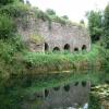
Waytown Limekilns
is a minor waterways place
on the Grand Western Canal between
Lowdwells (End of Navigation) (3½ furlongs
to the northeast) and
Sampford Peverell (4 miles and ¾ furlongs
to the southwest).
The nearest place in the direction of Lowdwells is Waytown Tunnel (western entrance);
½ furlongs
away.
The nearest place in the direction of Sampford Peverell is Whipcott Wharf Bridge;
2¼ furlongs
away.
Mooring here is unrated.
| Lowdwells | 3½ furlongs | |
| Waytown Tunnel (eastern entrance) | ¾ furlongs | |
| Waytown Tunnel (western entrance) | ½ furlongs | |
| Waytown Limekilns | ||
| Whipcott Wharf Bridge | 2¼ furlongs | |
| Fenacre Bridge | 6 furlongs | |
| Fossend Bridge | 1 mile, 1¼ furlongs | |
| Black Bridge (Westleigh) | 1 mile, 1¾ furlongs | |
| Ebear Bridge | 2 miles | |
There are no links to external websites from here.
Why not log in and add some (select "External websites" from the menu (sometimes this is under "Edit"))?
Why not log in and add some (select "External websites" from the menu (sometimes this is under "Edit"))?
Mouseover for more information or show routes to facility
Nearest place to turn
In the direction of Tiverton
Sampford Peverell Winding Hole — 4 miles, 1½ furlongs away
On this waterway in the direction of Tiverton
East Manley Bridge Winding Hole — 8 miles, 2¼ furlongs away
On this waterway in the direction of Tiverton
Bampfylde Close Winding Hole — 10 miles, ¾ furlongs away
On this waterway in the direction of Tiverton
Tiverton Winding Hole — 10 miles, 2 furlongs away
On this waterway in the direction of Tiverton
Tiverton — 10 miles, 3 furlongs away
On this waterway in the direction of TivertonNo information
CanalPlan has no information on any of the following facilities within range:water point
rubbish disposal
chemical toilet disposal
self-operated pump-out
boatyard pump-out
Direction of TV transmitter (From Wolfbane Cybernetic)
There is no page on Wikipedia called “Waytown Limekilns”
Wikipedia pages that might relate to Waytown Limekilns
[Grand Western Canal]
Historic England. "Waytown Limekilns (1140142)". National Heritage List for England. Retrieved 6 December 2007. Historic England. "Waytown Tunnel (1325913)"
[Holcombe Rogus]
Historic England. "Waytown Limekilns (1140142)". National Heritage List for England. Retrieved 6 December 2007. Historic England. "Waytown Tunnel (1325913)"
Results of Google Search
Holcombe Rogus - WikipediaHolcombe Rogus is a village and civil parish in the English county of Devon. The population of the parish is 503. The manor house known as Holcombe Court was built by the Bluett family. It is situated to the immediate west of the parish church, hidden behind a high boundary wall, and is described as "perhaps the finest ...
By the time this section was finished the extension plans from Burlcscombe to Topsham (joining up to the Exeter Canal) were abandoned. Artist's Impression of Waytown Limekilns and Tub Boats (When the canal was working). Canal milage. Tiverton to Lowdwells 11 1/4 miles (Wet Section Still Navigable and Used Today) .
The Grand Western Canal ran between Taunton in Somerset and Tiverton in Devon in the United Kingdom. The canal had its origins in various plans, going back to 1796, to link the Bristol Channel and the English Channel by a canal, bypassing Lands End. An additional purpose of the canal was the supply of limestone ...
Roundabout. Halberton. Tidcombe. Hall. Rock. House. Ayshford Chapel. Waytown Limekilns. Wharf. Cottage. Church. Church. P. Embankment. Toilets. Canal Shop &. Booking Office. Shops. 16. 3A. The Globe. Canal Side Pub. Shop. McDonalds. Manley. The Grand Western Canal MAP. Tiverton Canal Co. To Barnstable.
road bridges over the Canal. (designed by John Rennie) and the. 40m-long Waytown Tunnel. Other notable structures include milestones, culverts, wharves, accommodation bridges, an aqueduct and a lock. 3. Poster advertising a walk as part of the campaign to save the Canal. The Waytown Limekilns at the northern end ...
Right: The Waytown Limekilns are just one of many historic features you can visit on the Canal. 15 road bridges, nine of the original milestones, the 40m-long Waytown. Tunnel and an Isambard Kingdom. Brunel-designed aqueduct are others to look out for. Above: Stone being loaded onto barges at Whipcott Wharf during ...
Jul 18, 2017 ... The canal eventually came to a sad and rather abrupt end shortly after the old Waytown limekilns and very narrow tunnel, but my intended route (picking up the West Deane Way) followed the route that the rest of the canal formerly took. I was running short on water however and as my map indicated a ...
Nov 29, 2011 ... These four objects were created using hypr3D's online digitization platform - Check it out at hypr3D.com!
Explore Julie Webber's board "Holcombe Rogus" on Pinterest. | See more ideas about Devon, Family history and Ireland.
Explore Julie Webber's board "Holcombe Rogus" on Pinterest. | See more ideas about Devon, Family history and Ireland.


![Sloping access to the canal. This slope is beside the Waytown limekilns [[[3199630]]]. It looks as if the slope has been fenced to prevent farm animals straying into deep water by David Smith – 27 October 2012](https://s3.geograph.org.uk/geophotos/03/19/96/3199639_189a79dd_120x120.jpg)


![The road to Waytown Tunnel. The canal tunnel runs under the road close to the parked car. Beyond, in [[ST0719]], the woods in Beacon Hill Copse show autumn colour by David Smith – 27 October 2012](https://s3.geograph.org.uk/geophotos/03/19/96/3199619_ecee02af_120x120.jpg)


