CanalPlanAC

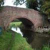
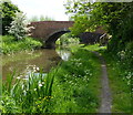
Main Street Field Bridge No 64

 
Scotter Lane, Bassetlaw DN22 9LH, United Kingdom
Address is taken from a point 220 yards away.
 
Information about the place
Main Street Field Bridge No 64 is a minor waterways place on the Chesterfield Canal (Retford to the Trent) between Wiseton Top Bridge No 70 (4 miles and 1¾ furlongs to the north) and West Retford Lock No 58 (Wharf Bridge) (3 miles and 5 furlongs and 2 locks to the southwest).
 
 
The nearest place in the direction of Wiseton Top Bridge No 70 is Scotter Lane Road Bridge No 65; 1 furlong away.
 
The nearest place in the direction of West Retford Lock No 58 is Church Bridge No 63; 2½ furlongs away.

There may be access to the towpath here.

Mooring here is unrated.

There is a bridge here which takes a track over the canal.


Amenities
 
Maps
If you are a user and are logged on, or if you are actively planning a route, a map will be displayed here.
Show on external mapping site: Google | OSM | Bing
 
Photos
 
External websites
There are no links to external websites from here.
Why not log in and add some (select "External websites" from the menu (sometimes this is under "Edit"))?
 
Nearest facilities

Mouseover for more information or show routes to facility

Nearest water point

In the direction of West Retford Lock No 58

Hop Pole Bridge No 592 miles, ½ furlongs and 1 lock away
On this waterway in the direction of West Retford Lock No 58
Forest Middle Top Lock No 556 miles, 2¼ furlongs and 5 locks away
Travel to West Retford Lock No 58, then on the Chesterfield Canal (Norwood to Retford) to Forest Middle Top Lock No 55
Forest Middle Top Water Point6 miles, 2½ furlongs and 6 locks away
Travel to West Retford Lock No 58, then on the Chesterfield Canal (Norwood to Retford) to Forest Middle Top Water Point
Shireoaks Marina15 miles, 6 furlongs and 19 locks away
Travel to West Retford Lock No 58, then on the Chesterfield Canal (Norwood to Retford) to Shireoaks Marina

In the direction of Chesterfield Canal - River Trent Junction

Clayworth CRT Boaters Facilities2 miles, 2¼ furlongs away
On this waterway in the direction of Chesterfield Canal - River Trent Junction
West Stockwith Basin11 miles, 7¼ furlongs and 4 locks away
On this waterway in the direction of Chesterfield Canal - River Trent Junction

Nearest rubbish disposal

In the direction of West Retford Lock No 58

Forest Middle Top Lock No 556 miles, 2¼ furlongs and 5 locks away
Travel to West Retford Lock No 58, then on the Chesterfield Canal (Norwood to Retford) to Forest Middle Top Lock No 55
Shireoaks Marina15 miles, 6 furlongs and 19 locks away
Travel to West Retford Lock No 58, then on the Chesterfield Canal (Norwood to Retford) to Shireoaks Marina

In the direction of Chesterfield Canal - River Trent Junction

Clayworth CRT Boaters Facilities2 miles, 2¼ furlongs away
On this waterway in the direction of Chesterfield Canal - River Trent Junction
West Stockwith Basin11 miles, 7¼ furlongs and 4 locks away
On this waterway in the direction of Chesterfield Canal - River Trent Junction

Nearest chemical toilet disposal

In the direction of West Retford Lock No 58

Forest Middle Top Lock No 556 miles, 2¼ furlongs and 5 locks away
Travel to West Retford Lock No 58, then on the Chesterfield Canal (Norwood to Retford) to Forest Middle Top Lock No 55
Cuckoo Wharf Elsan13 miles, 4¼ furlongs and 10 locks away
Travel to West Retford Lock No 58, then on the Chesterfield Canal (Norwood to Retford) to Cuckoo Wharf Elsan
Shireoaks Marina15 miles, 6 furlongs and 19 locks away
Travel to West Retford Lock No 58, then on the Chesterfield Canal (Norwood to Retford) to Shireoaks Marina

In the direction of Chesterfield Canal - River Trent Junction

Clayworth CRT Boaters Facilities2 miles, 2¼ furlongs away
On this waterway in the direction of Chesterfield Canal - River Trent Junction
West Stockwith Basin11 miles, 7¼ furlongs and 4 locks away
On this waterway in the direction of Chesterfield Canal - River Trent Junction

Nearest place to turn

In the direction of West Retford Lock No 58

Grove Mill Bridge Winding Hole2 miles, 6¾ furlongs and 1 lock away
On this waterway in the direction of West Retford Lock No 58
Retford Winding Hole3 miles, ½ furlongs and 1 lock away
On this waterway in the direction of West Retford Lock No 58
Babworth Winding Hole4 miles, 4½ furlongs and 3 locks away
Travel to West Retford Lock No 58, then on the Chesterfield Canal (Norwood to Retford) to Babworth Winding Hole
Forest Top Lock Winding Hole6 miles, 5 furlongs and 6 locks away
Travel to West Retford Lock No 58, then on the Chesterfield Canal (Norwood to Retford) to Forest Top Lock Winding Hole
Ranby Bridge Winding Hole8 miles, 7 furlongs and 7 locks away
Travel to West Retford Lock No 58, then on the Chesterfield Canal (Norwood to Retford) to Ranby Bridge Winding Hole
High Hoe Road Bridge Winding Hole12 miles, 7 furlongs and 9 locks away
Travel to West Retford Lock No 58, then on the Chesterfield Canal (Norwood to Retford) to High Hoe Road Bridge Winding Hole
Morse Lock Winding Hole13 miles, 7 furlongs and 11 locks away
Travel to West Retford Lock No 58, then on the Chesterfield Canal (Norwood to Retford) to Morse Lock Winding Hole
Junction with former Lady Lee Arm14 miles, 3¼ furlongs and 12 locks away
Travel to West Retford Lock No 58, then on the Chesterfield Canal (Norwood to Retford) to Junction with former Lady Lee Arm
Shireoaks Marina15 miles, 6 furlongs and 19 locks away
Travel to West Retford Lock No 58, then on the Chesterfield Canal (Norwood to Retford) to Shireoaks Marina
Little Lane Bridge Winding Hole16 miles, 5¾ furlongs and 27 locks away
Travel to West Retford Lock No 58, then on the Chesterfield Canal (Norwood to Retford) to Little Lane Bridge Winding Hole
Manor Road Winding Hole19 miles, 2½ furlongs and 42 locks away
Travel to West Retford Lock No 58, then on the Chesterfield Canal (Norwood to Retford) to Manor Road Winding Hole

In the direction of Chesterfield Canal - River Trent Junction

Main Street Winding Hole5 furlongs away
On this waterway in the direction of Chesterfield Canal - River Trent Junction
Clayworth Top Bridge Winding Hole2 miles, 3 furlongs away
On this waterway in the direction of Chesterfield Canal - River Trent Junction
Otter's Bridge Winding Hole2 miles, 7¾ furlongs away
On this waterway in the direction of Chesterfield Canal - River Trent Junction
Drakeholes Visitor Moorings5 miles, 3 furlongs away
On this waterway in the direction of Chesterfield Canal - River Trent Junction
Drakeholes Tunnel (southern entrance)5 miles, 3½ furlongs away
On this waterway in the direction of Chesterfield Canal - River Trent Junction
Manor Farm Winding Hole9 miles, 3 furlongs and 2 locks away
On this waterway in the direction of Chesterfield Canal - River Trent Junction
West Stockwith Basin11 miles, 7¼ furlongs and 4 locks away
On this waterway in the direction of Chesterfield Canal - River Trent Junction

No information

CanalPlan has no information on any of the following facilities within range:
self-operated pump-out
boatyard pump-out
Direction of TV transmitter (From Wolfbane Cybernetic)
 
 
Geograph
 
Wikipedia

There is no page on Wikipedia called “Main Street Field Bridge”

Wikipedia pages that might relate to Main Street Field Bridge
[Main Street Bridge (Jacksonville)] The Main Street Bridge, officially the John T. Alsop Jr. Bridge, is a bridge crossing the St. Johns River in Jacksonville, Florida. It was the second bridge [Bedford Falls (It's a Wonderful Life)] Hills. Genesee Street is the main road through Bedford Falls. At the north end is a courthouse with a street heading east down Bridge Street, which departs [Canal Street station (New York City Subway)] 1 m) below street BMT Nassau Street Line, 20 feet (6.1 m) BMT Broadway Line, main branch, 40 feet (12 m) BMT Broadway Line, Manhattan Bridge branch, 50 [Roosevelt Island] Firefighters Field, located next to the ferry terminal north of Queensboro Bridge; measures 303 by 178 feet (92 by 54 m) Octagon Field, located across [Roberto Clemente Bridge] Clemente Bridge, also known as the Sixth Street Bridge, spans the Allegheny River in downtown Pittsburgh, Pennsylvania, United States. The original bridge at [Tacoma Narrows Bridge (1940)] world's third-longest suspension bridge by main span, behind the Golden Gate Bridge and the George Washington Bridge. Construction began in September [Dames Point Bridge] 1985 and was completed in 1989. The main span is 1,300 feet (396.2 m), and is 175 feet (53.3 m) high. The bridge was designed by HNTB Corporation and [Back Bay Fens] North from Boylston Street in Charlesgate Park, the Muddy River is crossed by Ipswich Street, the Worcester Main Line railroad bridge, the Massachusetts [List of vertical-lift bridges] (1913–1932). In addition, there are also Bridges 13 (Main Street Bridge), 17 (Dain City Railway Bridge) and 18 (Forks Road Bridge) on the Welland Recreational Waterway [Bailey bridge] A Bailey bridge is a type of portable, pre-fabricated, truss bridge. It was developed in 1940–1941 by the British for military use during the Second World
 
Google

Results of Google Search

MTA LIRR - Flushing Main Street
... Metro-North Railroad · Bridges and Tunnels · MTA Capital Program ... Main Street and 41st Avenue, off Kissena Boulevard. ... Provider, Phone Number, Routes ... 15-18, 26, 27 28 Q19, Q25, Q34, Q50, Q65, Q66 Q44, 48, Q64 Subway 7.
Can you avoid the toll bridge going 65 south? - Louisville Forum ...
Jun 29, 2017 ... Do we have to use that one or can we use the old bridge without a toll? ... Hotels near Frazier History Museum · Hotels near Louisville Slugger Field .... I can't remember the exit number, but that will take you across the Clark Memorial Bridge .... Then, get on I64 east until it meets 65 south downtown Lou.
THE HISTORIC HIGHWAY BRIDGES OF FLORIDA
Dec 2, 2012 ... APPENDIX B: All Field Surveyed Bridges by FDOT District ...... Main Street Vertical Lift Bridge, Duval County (No. ...... 64 Samuel, Peter, “Florida's Turnpike celebrating 50th birthday & half price transponders,” TOLL ROADS ...
TCSA - Fields
... logo 210x210. Home; Fields ... Take Route 64 west of Randall Road to Brown Road which is approximately ¾ mile past Burlington Road. Turn north on ... Use parking lot west of fields (by baseball fields) off South Street. Enter the field by using the bridge and gate on the west side of the fields. NO PARKING ON STREET.
Maps & Directions - Longwood University
Take I-64 West to I-95 South, turn onto the downtown expressway (Route 195); take ... left onto High Street, the fourth traffic light after the Longwood playing fields. ... Take the NC-147 North exit, exit number 279 B, towards Durham/ Downtown.
City of Bradenton
Bradenton City Hall is located at 101 Old Main Street at the corner of Old Main Street ... Business US 41 (9th Street W) at the Green Bridge - While crews are ... The public meetings took place prior to Christmas but no decision has been made.
U.S. Route 40 - Wikipedia
U.S. Route 40 (US 40), also known as the Main Street of America, is an east– west United ... There would be no more major intersections until US 40 has reached .... into Illinois at East St. Louis on the Poplar Street Bridge concurrent with I-55/I-64. ... In downtown Indianapolis, the old highway crossed White River on a bridge ...
ConnDOT: Connecticut Park & Ride
Nov 6, 2018 ... Bristol, Todd St. No. of Route 72, 200, PLSE. Bristol, Mix St., Barnes Field Lot, 57, P. Bristol, Route ... East Hartford, Route 5 @ Main Street (Route 15 Exit 30), 255, PLSB .... Vernon, I-84 @ Route 30 (Exit 64-65), 179, PLSE. W.
Locations – OPTIMUS Health Care
OPTIMUS EAST MAIN HEALTH CARE (MAIN OFFICE) ... OPTIMUS Main Street Pediatrics ... 64 Black Rock Avenue ... OPTIMUS Bridges Primary Care Center.
Story Avenue ramp to westbound I-64 closing
Aug 28, 2015 ... Downtown crossing — Construction of a new bridge for northbound Interstate ... The ramp from Story Avenue to westbound Interstate 64 will close Monday. ... Intermittent closings on Witherspoon Street from Slugger Field to Clay Street, ... No direct access to northbound I-65 from the Clark Memorial Bridge.