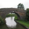
Bates Bridge No 50
is a minor waterways place
on the Ashby Canal (Main Line) between
Turn Bridge No 52 (Shackerstone) (5¾ furlongs
to the north) and
Congerstone Bridge No 47 (4 furlongs
to the southwest).
The nearest place in the direction of Turn Bridge No 52 (Shackerstone) is Bates Wharf Bridge No 51;
1½ furlongs
away.
The nearest place in the direction of Congerstone Bridge No 47 is Terrace Bridge No 49;
1¾ furlongs
away.
There is no access to the towpath here.
Mooring here is unrated.
There is a bridge here which takes a track over the canal.
| Town Bridge No 53 | 7¾ furlongs | |
| Turn Bridge No 52 (Shackerstone) | 5¾ furlongs | |
| The Rising Sun PH (Shackerstone) | 5½ furlongs | |
| River Sence Aqueduct | 4¾ furlongs | |
| Bates Wharf Bridge No 51 | 1½ furlongs | |
| Bates Bridge No 50 | ||
| Terrace Bridge No 49 | 1¾ furlongs | |
| Dakins Bridge No 48 | 3¼ furlongs | |
| Congerstone Bridge No 47 | 4 furlongs | |
| Fairfield Bridge No 46 | 1 mile, ¼ furlongs | |
| Lliffe Bridge No 45 | 1 mile, 2½ furlongs | |
Mouseover for more information or show routes to facility
Nearest water point
In the direction of Ashby Canal Current Head of Navigation
Snarestone Services — 3 miles, 6 furlongs away
On this waterway in the direction of Ashby Canal Current Head of Navigation
In the direction of Marston Junction
Bosworth Marina & Wharf Winding Hole — 2 miles, 5¼ furlongs away
On this waterway in the direction of Marston Junction
Bosworth Wharf Bridge No 42 — 2 miles, 5½ furlongs away
On this waterway in the direction of Marston Junction
Sutton Cheney Wharf — 6 miles, 2¼ furlongs away
On this waterway in the direction of Marston Junction
Trinity Marina — 11 miles, 4¼ furlongs away
On this waterway in the direction of Marston Junction
Limekiln Bridge No 15 — 12 miles, 4¼ furlongs away
On this waterway in the direction of Marston JunctionNearest rubbish disposal
In the direction of Ashby Canal Current Head of Navigation
Snarestone Services — 3 miles, 6 furlongs away
On this waterway in the direction of Ashby Canal Current Head of Navigation
In the direction of Marston Junction
Bosworth Marina & Wharf Winding Hole — 2 miles, 5¼ furlongs away
On this waterway in the direction of Marston Junction
Stoke Golding Wharf — 8 miles, 6¼ furlongs away
On this waterway in the direction of Marston Junction
Trinity Marina — 11 miles, 4¼ furlongs away
On this waterway in the direction of Marston JunctionNearest chemical toilet disposal
In the direction of Ashby Canal Current Head of Navigation
Snarestone Services — 3 miles, 6 furlongs away
On this waterway in the direction of Ashby Canal Current Head of Navigation
In the direction of Marston Junction
Bosworth Marina & Wharf Winding Hole — 2 miles, 5¼ furlongs away
On this waterway in the direction of Marston Junction
Sutton Cheney Wharf — 6 miles, 2¼ furlongs away
On this waterway in the direction of Marston Junction
Trinity Marina — 11 miles, 4¼ furlongs away
On this waterway in the direction of Marston JunctionNearest place to turn
In the direction of Marston Junction
Carlton Bridge Winding Hole — 1 mile, 5½ furlongs away
On this waterway in the direction of Marston Junction
Bosworth Marina & Wharf Winding Hole — 2 miles, 5¼ furlongs away
On this waterway in the direction of Marston Junction
Jackson's Bridge Winding Hole — 2 miles, 7¾ furlongs away
On this waterway in the direction of Marston Junction
Shenton Bend — 4 miles, 7 furlongs away
On this waterway in the direction of Marston Junction
Sutton Cheney Wharf — 6 miles, 2¼ furlongs away
On this waterway in the direction of Marston Junction
Basin Bridge Winding Hole — 9 miles, 3¾ furlongs away
On this waterway in the direction of Marston Junction
Trinity Marina — 11 miles, 4¼ furlongs away
On this waterway in the direction of Marston Junction
Hinckley Wharf Arm Junction — 12 miles away
On this waterway in the direction of Marston Junction
Marston Junction — 17 miles, 4¾ furlongs away
On this waterway in the direction of Marston Junction
Junction with Griff Arm (disused) — 18 miles, 5½ furlongs away
Travel to Marston Junction, then on the Coventry Canal (Main Line - Hawkesbury to Fazeley) to Junction with Griff Arm (disused)
Bedworth Winding Hole — 19 miles, 4 furlongs away
Travel to Marston Junction, then on the Coventry Canal (Main Line - Hawkesbury to Fazeley) to Bedworth Winding Hole
In the direction of Ashby Canal Current Head of Navigation
Shackerstone Winding Hole — 7¾ furlongs away
On this waterway in the direction of Ashby Canal Current Head of Navigation
Turnover Bridge Winding Hole — 3 miles, 6 furlongs away
On this waterway in the direction of Ashby Canal Current Head of Navigation
Faulkes Circular Winding Hole — 3 miles, 7¾ furlongs away
On this waterway in the direction of Ashby Canal Current Head of Navigation
Measham Wharf Branch Junction — 5 miles, 5¾ furlongs away
Travel to Ashby Canal Current Head of Navigation, then on the Ashby Canal (unrestored) to Measham Wharf Branch Junction
Site of Proposed Measham Wharf — 6 miles, ½ furlongs away
Travel to Ashby Canal Current Head of Navigation, then on the Ashby Canal (unrestored) to Measham Wharf Branch Junction, then on the Ashby Canal (Measham Wharf Branch, unrestored) to Site of Proposed Measham Wharf
Bath Yard Basin — 9 miles, 4 furlongs and 1 lock away
Travel to Ashby Canal Current Head of Navigation, then on the Ashby Canal (unrestored) to Brooks Close Terminus, then on the Ashby Canal (restored but unconnected) to Bath Yard BasinNearest self-operated pump-out
In the direction of Marston Junction
Bosworth Marina & Wharf Winding Hole — 2 miles, 5¼ furlongs away
On this waterway in the direction of Marston Junction
Trinity Marina — 11 miles, 4¼ furlongs away
On this waterway in the direction of Marston JunctionNearest boatyard pump-out
In the direction of Marston Junction
Trinity Marina — 11 miles, 4¼ furlongs away
On this waterway in the direction of Marston Junction
Boot Wharf — 19 miles, 5¾ furlongs away
Travel to Marston Junction, then on the Coventry Canal (Main Line - Hawkesbury to Fazeley) to Boot WharfDirection of TV transmitter (From Wolfbane Cybernetic)
There is no page on Wikipedia called “Bates Bridge”
Wikipedia pages that might relate to Bates Bridge
[Bat bridge]
A bat bridge is a structure of varying construction crossing a new or altered road to aid the navigation of bats following the destruction of a hedgerow
[Ann W. Richards Congress Avenue Bridge]
lanes and sidewalks on both sides of the bridge. The bridge is currently home to the world's largest urban bat colony. It is a maternity colony, meaning
[Ken Bates]
was confirmed that Bates had become the sole owner. In November 2012, Bates sold his holdings in Leeds United to GFH Capital. Bates was born in Ealing
[Michael Bates (actor)]
(1974–77). Bates was born in Jhansi, United Provinces, India. His parents were of Cheshire families; his father, Henry Stuart “Harry” Bates (1893–1985)
[Bat]
bat retreat". BBC. 6 April 2006. Retrieved 18 May 2006. "Bypass wings it with bat bridges". BBC. 4 April 2008. Retrieved 21 August 2016. "Bat bridges
[Kathy Bates filmography]
and directing credits from actress Kathy Bates. With over 200 acting and directing credits to her name, Bates is perhaps best known for her breakout role
[Stamford Bridge (stadium)]
between Bates and Marler Estates. Marler Estates was ultimately forced into bankruptcy after a market crash in the early 1990s, allowing Bates to do a
[Bates]
Alan Bates (1934–2003), British actor Albert Bates (born 1947), U.S. environmentalist Allie Bates (born 1957), U.S. magazine writer Alta Bates (1879–1955)
[Michael Bates, Baron Bates]
Michael Walton Bates, Baron Bates (born 26 May 1961) is a Conservative Party politician in the United Kingdom serving in the House of Lords since 2008
[Massachusetts Route 113]
traffic. In 2010, a project began to replace the Bates Bridge in Haverhill/Groveland with a modern bridge. The project is expected to take two to three years
Results of Google Search
Bates bridge30 records ... 37 Bates Bridge Rd , Travelers Rest, SC 29690-9215 is currently not for sale. ... The Congaree River Blue Trail is a 50-mile designated recreational ...
Deck plate girder bridge over Merrimack River on MA Route 97/113. ... 42°45'50" N, 71°02'01" W (degrees°minutes'seconds"); Approximate UTM coordinates ... Quadrangle map: Haverhill; Inventory number: BH 70262 (Bridgehunter.com ID) ...
Jul 15, 2020 ... The property 118 Bates Bridge Rd, Travelers Rest, SC 29690 is currently not for sale on Zillow. View details, sales history and Zestimate data ...
Mar 5, 2017 ... Bates Bridge, No 50 across the Ashby Canal is a farmer's accommodation bridge with no public right of way on it or into adjacent fields. Work to ...
The property 60 Bates Bridge Rd, Travelers Rest, SC 29690 is currently not for sale on Zillow. View details, sales history and Zestimate data for this property on ...
Dec 7, 2020 ... Can you believe it's been almost 50 years since we graduated? The 50th Reunion Committee invites you to a holiday happy hour!
View, JUVENILE, 16, ADRIAN, MO, MINOR, NO, 12/10/2020, 2:50PM, BATES ... 12:50PM, HENRY, NORTHBOUND MO-13 ON THE DEEPWATER BRIDGE, A.
There are several organizations that are not recognized by BCSG but still maintain ... ALL students (not just women!) to join in the community that aims to bridge gaps, ... We are now an incredible team of about ~50 athletic people who take the ...
The 50-mile Congaree River Blue Trail connects the City of Columbia, the Three ... Bridge, it's approximately 2.5 miles to the finish at Bates Bridge Landing.