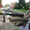
Misterton Low Lock No 64
is a minor waterways place
on the Chesterfield Canal (Retford to the Trent) between
Chesterfield Canal - River Trent Junction (West Stockwith) (5¾ furlongs
and 1 lock
to the east) and
Cooper's Bridge No 80 (Misterton) (1 mile
and 1 lock
to the west).
The nearest place in the direction of Chesterfield Canal - River Trent Junction is Misterton Low Lock Bridge No 83;
a few yards
away.
The nearest place in the direction of Cooper's Bridge No 80 is Station Street Bridge No 82A (Misterton);
¼ furlongs
away.
Mooring here is unrated.
This is a lock with a rise of 6 feet and 8 inches.
West Stockwith Lock | 5½ furlongs | |
West Stockwith Basin | 5¼ furlongs | |
Stockwith Bridge No 85 | 5 furlongs | |
Railway Bridge No 84 | ¾ furlongs | |
Misterton Low Lock Bridge No 83 | a few yards | |
Misterton Low Lock No 64 | ||
Station Street Bridge No 82A (Misterton) | ¼ furlongs | |
Misterton Top Lock No 63 | ¾ furlongs | |
Hillsyde Avenue Field Bridge No 82 | 1¾ furlongs | |
Misterton Shopping Moorings | 3¼ furlongs | |
Grove Wood Road Bridge No 81 | 3½ furlongs |
There are no links to external websites from here.
Why not log in and add some (select "External websites" from the menu (sometimes this is under "Edit"))?
Mouseover for more information or show routes to facility
Nearest water point
In the direction of West Retford Lock No 58
Clayworth CRT Boaters Facilities — 8 miles, 7¾ furlongs and 4 locks away
On this waterway in the direction of West Retford Lock No 58
Hop Pole Bridge No 59 — 13 miles, 2½ furlongs and 5 locks away
On this waterway in the direction of West Retford Lock No 58
Forest Middle Top Lock No 55 — 17 miles, 4¼ furlongs and 9 locks away
Travel to West Retford Lock No 58, then on the Chesterfield Canal (Norwood to Retford) to Forest Middle Top Lock No 55
Forest Middle Top Water Point — 17 miles, 4½ furlongs and 10 locks away
Travel to West Retford Lock No 58, then on the Chesterfield Canal (Norwood to Retford) to Forest Middle Top Water Point
In the direction of Chesterfield Canal - River Trent Junction
West Stockwith Basin — 5¼ furlongs and 1 lock away
On this waterway in the direction of Chesterfield Canal - River Trent Junction
Keadby Visitor Moorings — 13 miles, 4¾ furlongs and 3 locks away
Travel to Chesterfield Canal - River Trent Junction, then on the River Trent (tidal section - Cromwell to Keadby) to Keadby Junction, then on the Sheffield and South Yorkshire Navigation (Stainforth and Keadby Canal) to Keadby Visitor Moorings
Torksey Lock — 15 miles, 6¼ furlongs and 2 locks away
Travel to Chesterfield Canal - River Trent Junction, then on the River Trent (tidal section - Cromwell to Keadby) to Torksey Junction, then on the Fossdyke Canal to Torksey LockNearest rubbish disposal
In the direction of West Retford Lock No 58
Clayworth CRT Boaters Facilities — 8 miles, 7¾ furlongs and 4 locks away
On this waterway in the direction of West Retford Lock No 58
Forest Middle Top Lock No 55 — 17 miles, 4¼ furlongs and 9 locks away
Travel to West Retford Lock No 58, then on the Chesterfield Canal (Norwood to Retford) to Forest Middle Top Lock No 55
In the direction of Chesterfield Canal - River Trent Junction
West Stockwith Basin — 5¼ furlongs and 1 lock away
On this waterway in the direction of Chesterfield Canal - River Trent Junction
Keadby Visitor Moorings — 13 miles, 4¾ furlongs and 3 locks away
Travel to Chesterfield Canal - River Trent Junction, then on the River Trent (tidal section - Cromwell to Keadby) to Keadby Junction, then on the Sheffield and South Yorkshire Navigation (Stainforth and Keadby Canal) to Keadby Visitor Moorings
Torksey Lock — 15 miles, 6¼ furlongs and 2 locks away
Travel to Chesterfield Canal - River Trent Junction, then on the River Trent (tidal section - Cromwell to Keadby) to Torksey Junction, then on the Fossdyke Canal to Torksey LockNearest chemical toilet disposal
In the direction of West Retford Lock No 58
Clayworth CRT Boaters Facilities — 8 miles, 7¾ furlongs and 4 locks away
On this waterway in the direction of West Retford Lock No 58
Forest Middle Top Lock No 55 — 17 miles, 4¼ furlongs and 9 locks away
Travel to West Retford Lock No 58, then on the Chesterfield Canal (Norwood to Retford) to Forest Middle Top Lock No 55
In the direction of Chesterfield Canal - River Trent Junction
West Stockwith Basin — 5¼ furlongs and 1 lock away
On this waterway in the direction of Chesterfield Canal - River Trent Junction
Keadby Visitor Moorings — 13 miles, 4¾ furlongs and 3 locks away
Travel to Chesterfield Canal - River Trent Junction, then on the River Trent (tidal section - Cromwell to Keadby) to Keadby Junction, then on the Sheffield and South Yorkshire Navigation (Stainforth and Keadby Canal) to Keadby Visitor Moorings
Torksey Lock — 15 miles, 6¼ furlongs and 2 locks away
Travel to Chesterfield Canal - River Trent Junction, then on the River Trent (tidal section - Cromwell to Keadby) to Torksey Junction, then on the Fossdyke Canal to Torksey LockNearest place to turn
In the direction of West Retford Lock No 58
Manor Farm Winding Hole — 1 mile, 7 furlongs and 2 locks away
On this waterway in the direction of West Retford Lock No 58
Drakeholes Tunnel (southern entrance) — 5 miles, 6¾ furlongs and 4 locks away
On this waterway in the direction of West Retford Lock No 58
Drakeholes Visitor Moorings — 5 miles, 7 furlongs and 4 locks away
On this waterway in the direction of West Retford Lock No 58
Otter's Bridge Winding Hole — 8 miles, 2¼ furlongs and 4 locks away
On this waterway in the direction of West Retford Lock No 58
Clayworth Top Bridge Winding Hole — 8 miles, 7 furlongs and 4 locks away
On this waterway in the direction of West Retford Lock No 58
Main Street Winding Hole — 10 miles, 5 furlongs and 4 locks away
On this waterway in the direction of West Retford Lock No 58
Grove Mill Bridge Winding Hole — 14 miles, ¾ furlongs and 5 locks away
On this waterway in the direction of West Retford Lock No 58
Retford Winding Hole — 14 miles, 2½ furlongs and 5 locks away
On this waterway in the direction of West Retford Lock No 58
Babworth Winding Hole — 15 miles, 6½ furlongs and 7 locks away
Travel to West Retford Lock No 58, then on the Chesterfield Canal (Norwood to Retford) to Babworth Winding Hole
Forest Top Lock Winding Hole — 17 miles, 7 furlongs and 10 locks away
Travel to West Retford Lock No 58, then on the Chesterfield Canal (Norwood to Retford) to Forest Top Lock Winding Hole
In the direction of Chesterfield Canal - River Trent Junction
West Stockwith Basin — 5¼ furlongs and 1 lock away
On this waterway in the direction of Chesterfield Canal - River Trent JunctionNearest self-operated pump-out
In the direction of Chesterfield Canal - River Trent Junction
Torksey Lock — 15 miles, 6¼ furlongs and 2 locks away
Travel to Chesterfield Canal - River Trent Junction, then on the River Trent (tidal section - Cromwell to Keadby) to Torksey Junction, then on the Fossdyke Canal to Torksey LockNo information
CanalPlan has no information on any of the following facilities within range:boatyard pump-out
Direction of TV transmitter (From Wolfbane Cybernetic)
There is no page on Wikipedia called “Misterton Low Lock”
Wikipedia pages that might relate to Misterton Low Lock
[Chesterfield Canal]
cafe. It is located by Hollingwood Lock, and consists of a large new extension on the back of the refurbished lock house. Lead had been mined in Derbyshire
[River Idle]
at Misterton Soss was abandoned. The south wall and floor of the lock were removed, and the river level was allowed to run down to the level of low water
[Nottinghamshire]
streams from Sherwood Forest, run through wide and flat valleys, merging at Misterton. A point just north of Newtonwood Lane, on the boundary with Derbyshire
[Retford]
and agriculture over the last three hundred years. 85Ha 'Mother Drain, Misterton' - Ditch and banks of considerable zoological interest and of some botanical
[List of electoral wards in England by constituency]
Lutterworth Orchard, Lutterworth Springs, Lutterworth Swift, Millfield, Misterton, Narborough and Littlethorpe, Normanton, North Whetstone, Pastures, Peatling
[List of poor law unions in England]
Waltoll in Knaptoft, Knaptoft, Leire, Little Claybrooke, Lutterworth, Misterton, North Kilworth, Peatling Magna, Peatling Parva, Shawell, Shearsby, South
[List of ecclesiastical parishes in the Diocese of Bath and Wells]
the rural area is within the Bristol and Bath Green Belt. The Deanery of Locking covers Weston-super-Mare and the surrounding villages. It is mostly within
Results of Google Search
May 12, 2009 ... No higher resolution available. ... English: Misterton Low Lock Lock 64 on the Chesterfield Canal at Misterton. Date, 12 May 2009.
Misterton low lock(64). A161 Station Street bridge, Misterton (82a). Misterton high lock (63). B1403 Misterton Coopers Bridge (80). Shaw Lock (62). Gringley Top ...
The Chesterfield Canal is a narrow canal in the East Midlands of England and it is known ... Misterton low lock(64) ... Misterton high lock (63) ... There was no proper system of road maintenance, and so the use of carts and wagons for the ...
Sep 30, 2016 ... Crossing the Chesterfield Canal and Cuckoo Way next to Misterton Low Lock No 64.
Download this stock image: Misterton Low Lock, Chesterfield Canal, Nottinghamshire. - BJJM9M from Alamy's library of millions of high resolution stock photos, ...
Chesterfield Canal 2006-7 by Christine Richardson and John Lower, ISBN: ... N. SK773945. 112. Misterton Low Lock No 64. 44.8. 64. N. SK773946. 112.
Chesterfield Canal West Stockwith Junction, River Trent Tidal Lock (65) West ... to Lincoln railway bridge (84) Misterton low lock(64) A161 Station Street bridge, ... Erewash Canal 18.3km River Trent 18.2km Trent Lock (No.60) 17.1km Sheet ...