

Lichfield Basin, Stourport
Waters Edge, Wyre Forest DY13 9FJ, United Kingdom
The Staffordshire and Worcestershire Canal (Stourport Basins: Lichfield Basin) was built by Exuperius Picking Junior and opened on 17 September 1888. In his autobiography Cecil Wright writes of his experiences as a boatman in the 1960s

Lichfield Basin, Stourport
is a major waterways place
at the end of the Staffordshire and Worcestershire Canal (Stourport Basins: Lichfield Basin); past
Stourport Upper Basin (½ furlongs
to the northwest).
The nearest place in the direction of Stourport Upper Basin is Mart Lane Bridge;
¼ furlongs
away.
Mooring here is unrated.
| Stourport Upper Basin | ½ furlongs | |
| Mart Lane Bridge | ¼ furlongs | |
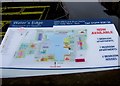
| Lichfield Basin, Stourport | ||
Amenities here
Amenities in Stourport
Amenities at other places in Stourport


There are no links to external websites from here.
Why not log in and add some (select "External websites" from the menu (sometimes this is under "Edit"))?
Why not log in and add some (select "External websites" from the menu (sometimes this is under "Edit"))?
Mouseover for more information or show routes to facility
Nearest water point
In the direction of Stourport Upper Basin
Upper Basin Waterpoint — ¾ furlongs away
Travel to Stourport Upper Basin, then on the Staffordshire and Worcestershire Canal (Stourport Basins: Narrow Route) to Upper Basin Waterpoint
Lincomb Lock — 1 mile, 3¾ furlongs and 2 locks away
Travel to Stourport Upper Basin, then on the Staffordshire and Worcestershire Canal (Stourport Basins: Broad Route) to Severn - Stourport Broad Locks Entrance, then on the River Severn (main river - Stourport to Worcester) to Lincomb Lock
Caldwall Mill Bridge No 14 — 3 miles, 7 furlongs and 3 locks away
Travel to Stourport Upper Basin, then on the Staffordshire and Worcestershire Canal (Stourport Basins: Narrow Route) to York Street Bridge, then on the Staffordshire and Worcestershire Canal (Main Line: Stourport to Stourton) to Caldwall Mill Bridge No 14
Holt Lock (Holt Fleet) — 5 miles, 5½ furlongs and 3 locks away
Travel to Stourport Upper Basin, then on the Staffordshire and Worcestershire Canal (Stourport Basins: Broad Route) to Severn - Stourport Broad Locks Entrance, then on the River Severn (main river - Stourport to Worcester) to Holt Lock (Holt Fleet)
Worcester Trip Boat Moorings — 12 miles, 2¼ furlongs and 5 locks away
Travel to Stourport Upper Basin, then on the Staffordshire and Worcestershire Canal (Stourport Basins: Broad Route) to Severn - Stourport Broad Locks Entrance, then on the River Severn (main river - Stourport to Worcester) to Worcester Trip Boat Moorings
Diglis Locks — 13 miles, 2¾ furlongs and 5 locks away
Travel to Stourport Upper Basin, then on the Staffordshire and Worcestershire Canal (Stourport Basins: Broad Route) to Severn - Stourport Broad Locks Entrance, then on the River Severn (main river - Stourport to Worcester) to Diglis Junction, then on the River Severn (main river - Worcester to Gloucester) to Diglis Locks
Kinver Services — 10 miles, 6 furlongs and 9 locks away
Travel to Stourport Upper Basin, then on the Staffordshire and Worcestershire Canal (Stourport Basins: Narrow Route) to York Street Bridge, then on the Staffordshire and Worcestershire Canal (Main Line: Stourport to Stourton) to Kinver Services
Diglis Services — 13 miles, 2 furlongs and 7 locks away
Travel to Stourport Upper Basin, then on the Staffordshire and Worcestershire Canal (Stourport Basins: Broad Route) to Severn - Stourport Broad Locks Entrance, then on the River Severn (main river - Stourport to Worcester) to Diglis Junction, then on the Worcester and Birmingham Canal (Diglis Junction to Diglis Basin) to Diglis Basin, then on the Worcester and Birmingham Canal (Diglis Basin to King's Norton Junction) to Diglis Services
Stewponey Water Point — 12 miles, 1¾ furlongs and 11 locks away
Travel to Stourport Upper Basin, then on the Staffordshire and Worcestershire Canal (Stourport Basins: Narrow Route) to York Street Bridge, then on the Staffordshire and Worcestershire Canal (Main Line: Stourport to Stourton) to Stewponey Water Point
Lowesmoor Basin — 14 miles, 1¾ furlongs and 9 locks away
Travel to Stourport Upper Basin, then on the Staffordshire and Worcestershire Canal (Stourport Basins: Broad Route) to Severn - Stourport Broad Locks Entrance, then on the River Severn (main river - Stourport to Worcester) to Diglis Junction, then on the Worcester and Birmingham Canal (Diglis Junction to Diglis Basin) to Diglis Basin, then on the Worcester and Birmingham Canal (Diglis Basin to King's Norton Junction) to Lowesmoor Basin
Netherwich Basin — 14 miles, ¾ furlongs and 12 locks away
Travel to Stourport Upper Basin, then on the Staffordshire and Worcestershire Canal (Stourport Basins: Broad Route) to Severn - Stourport Broad Locks Entrance, then on the River Severn (main river - Stourport to Worcester) to Hawford Junction, then on the Droitwich Canals (Droitwich Barge Canal) to Netherwich Basin
Greensforge Wharf Services — 15 miles, 1½ furlongs and 14 locks away
Travel to Stourport Upper Basin, then on the Staffordshire and Worcestershire Canal (Stourport Basins: Narrow Route) to York Street Bridge, then on the Staffordshire and Worcestershire Canal (Main Line: Stourport to Stourton) to Stourton Junction, then on the Staffordshire and Worcestershire Canal (Main Line: Stourton to Aldersley) to Greensforge Wharf Services
Stourbridge Visitor Moorings — 15 miles, 2¾ furlongs and 15 locks away
Travel to Stourport Upper Basin, then on the Staffordshire and Worcestershire Canal (Stourport Basins: Narrow Route) to York Street Bridge, then on the Staffordshire and Worcestershire Canal (Main Line: Stourport to Stourton) to Stourton Junction, then on the Stourbridge Canals (Main Line) to Wordsley Junction, then on the Stourbridge Canals (Stourbridge Branch) to Stourbridge Visitor Moorings
Droitwich Spa Marina — 15 miles, 4¼ furlongs and 17 locks away
Travel to Stourport Upper Basin, then on the Staffordshire and Worcestershire Canal (Stourport Basins: Broad Route) to Severn - Stourport Broad Locks Entrance, then on the River Severn (main river - Stourport to Worcester) to Hawford Junction, then on the Droitwich Canals (Droitwich Barge Canal) to Droitwich Junction, then on the Droitwich Canals (Droitwich Junction Canal) to Droitwich Spa Marina
Hanbury Boatyard — 16 miles, ½ furlongs and 20 locks away
Travel to Stourport Upper Basin, then on the Staffordshire and Worcestershire Canal (Stourport Basins: Broad Route) to Severn - Stourport Broad Locks Entrance, then on the River Severn (main river - Stourport to Worcester) to Hawford Junction, then on the Droitwich Canals (Droitwich Barge Canal) to Droitwich Junction, then on the Droitwich Canals (Droitwich Junction Canal) to Hanbury Junction, then on the Worcester and Birmingham Canal (Diglis Basin to King's Norton Junction) to Hanbury Boatyard
Stoke Works Water Point — 18 miles, 3¾ furlongs and 26 locks away
Travel to Stourport Upper Basin, then on the Staffordshire and Worcestershire Canal (Stourport Basins: Broad Route) to Severn - Stourport Broad Locks Entrance, then on the River Severn (main river - Stourport to Worcester) to Hawford Junction, then on the Droitwich Canals (Droitwich Barge Canal) to Droitwich Junction, then on the Droitwich Canals (Droitwich Junction Canal) to Hanbury Junction, then on the Worcester and Birmingham Canal (Diglis Basin to King's Norton Junction) to Stoke Works Water PointNearest rubbish disposal
In the direction of Stourport Upper Basin
Upper Basin Waterpoint — ¾ furlongs away
Travel to Stourport Upper Basin, then on the Staffordshire and Worcestershire Canal (Stourport Basins: Narrow Route) to Upper Basin Waterpoint
Sabrina Footbridge — 12 miles, ½ furlongs and 5 locks away
Travel to Stourport Upper Basin, then on the Staffordshire and Worcestershire Canal (Stourport Basins: Broad Route) to Severn - Stourport Broad Locks Entrance, then on the River Severn (main river - Stourport to Worcester) to Sabrina Footbridge
Kinver Services — 10 miles, 6 furlongs and 9 locks away
Travel to Stourport Upper Basin, then on the Staffordshire and Worcestershire Canal (Stourport Basins: Narrow Route) to York Street Bridge, then on the Staffordshire and Worcestershire Canal (Main Line: Stourport to Stourton) to Kinver Services
Diglis Basin — 13 miles, 1½ furlongs and 7 locks away
Travel to Stourport Upper Basin, then on the Staffordshire and Worcestershire Canal (Stourport Basins: Broad Route) to Severn - Stourport Broad Locks Entrance, then on the River Severn (main river - Stourport to Worcester) to Diglis Junction, then on the Worcester and Birmingham Canal (Diglis Junction to Diglis Basin) to Diglis Basin
Lowesmoor Basin — 14 miles, 1¾ furlongs and 9 locks away
Travel to Stourport Upper Basin, then on the Staffordshire and Worcestershire Canal (Stourport Basins: Broad Route) to Severn - Stourport Broad Locks Entrance, then on the River Severn (main river - Stourport to Worcester) to Diglis Junction, then on the Worcester and Birmingham Canal (Diglis Junction to Diglis Basin) to Diglis Basin, then on the Worcester and Birmingham Canal (Diglis Basin to King's Norton Junction) to Lowesmoor Basin
Netherwich Basin — 14 miles, ¾ furlongs and 12 locks away
Travel to Stourport Upper Basin, then on the Staffordshire and Worcestershire Canal (Stourport Basins: Broad Route) to Severn - Stourport Broad Locks Entrance, then on the River Severn (main river - Stourport to Worcester) to Hawford Junction, then on the Droitwich Canals (Droitwich Barge Canal) to Netherwich Basin
Greensforge Wharf Services — 15 miles, 1½ furlongs and 14 locks away
Travel to Stourport Upper Basin, then on the Staffordshire and Worcestershire Canal (Stourport Basins: Narrow Route) to York Street Bridge, then on the Staffordshire and Worcestershire Canal (Main Line: Stourport to Stourton) to Stourton Junction, then on the Staffordshire and Worcestershire Canal (Main Line: Stourton to Aldersley) to Greensforge Wharf Services
Stourbridge Basin — 15 miles, 5 furlongs and 15 locks away
Travel to Stourport Upper Basin, then on the Staffordshire and Worcestershire Canal (Stourport Basins: Narrow Route) to York Street Bridge, then on the Staffordshire and Worcestershire Canal (Main Line: Stourport to Stourton) to Stourton Junction, then on the Stourbridge Canals (Main Line) to Wordsley Junction, then on the Stourbridge Canals (Stourbridge Branch) to Stourbridge Basin
Droitwich Spa Marina — 15 miles, 4¼ furlongs and 17 locks away
Travel to Stourport Upper Basin, then on the Staffordshire and Worcestershire Canal (Stourport Basins: Broad Route) to Severn - Stourport Broad Locks Entrance, then on the River Severn (main river - Stourport to Worcester) to Hawford Junction, then on the Droitwich Canals (Droitwich Barge Canal) to Droitwich Junction, then on the Droitwich Canals (Droitwich Junction Canal) to Droitwich Spa Marina
Bratch Bottom Lock No 23 — 18 miles, 6¾ furlongs and 20 locks away
Travel to Stourport Upper Basin, then on the Staffordshire and Worcestershire Canal (Stourport Basins: Narrow Route) to York Street Bridge, then on the Staffordshire and Worcestershire Canal (Main Line: Stourport to Stourton) to Stourton Junction, then on the Staffordshire and Worcestershire Canal (Main Line: Stourton to Aldersley) to Bratch Bottom Lock No 23
Stoke Bottom Lock No 23 — 19 miles, 1½ furlongs and 26 locks away
Travel to Stourport Upper Basin, then on the Staffordshire and Worcestershire Canal (Stourport Basins: Broad Route) to Severn - Stourport Broad Locks Entrance, then on the River Severn (main river - Stourport to Worcester) to Hawford Junction, then on the Droitwich Canals (Droitwich Barge Canal) to Droitwich Junction, then on the Droitwich Canals (Droitwich Junction Canal) to Hanbury Junction, then on the Worcester and Birmingham Canal (Diglis Basin to King's Norton Junction) to Stoke Bottom Lock No 23
Delph Bottom Lock No 8 — 18 miles, 7¾ furlongs and 31 locks away
Travel to Stourport Upper Basin, then on the Staffordshire and Worcestershire Canal (Stourport Basins: Narrow Route) to York Street Bridge, then on the Staffordshire and Worcestershire Canal (Main Line: Stourport to Stourton) to Stourton Junction, then on the Stourbridge Canals (Main Line) to Black Delph, then on the Birmingham Canal Navigations (Dudley Canal No 1 - Through Route) to Delph Bottom Lock No 8
Waterfront Services (Dudley) — 19 miles, 7½ furlongs and 39 locks away
Travel to Stourport Upper Basin, then on the Staffordshire and Worcestershire Canal (Stourport Basins: Narrow Route) to York Street Bridge, then on the Staffordshire and Worcestershire Canal (Main Line: Stourport to Stourton) to Stourton Junction, then on the Stourbridge Canals (Main Line) to Black Delph, then on the Birmingham Canal Navigations (Dudley Canal No 1 - Through Route) to Waterfront Services (Dudley)Nearest chemical toilet disposal
In the direction of Stourport Upper Basin
Upper Basin Waterpoint — ¾ furlongs away
Travel to Stourport Upper Basin, then on the Staffordshire and Worcestershire Canal (Stourport Basins: Narrow Route) to Upper Basin Waterpoint
Stourport Marina — 1 mile, ½ furlongs and 2 locks away
Travel to Stourport Upper Basin, then on the Staffordshire and Worcestershire Canal (Stourport Basins: Broad Route) to Severn - Stourport Broad Locks Entrance, then on the River Severn (main river - Stourport to Worcester) to Stourport Marina
Caldwall Mill Bridge No 14 — 3 miles, 7 furlongs and 3 locks away
Travel to Stourport Upper Basin, then on the Staffordshire and Worcestershire Canal (Stourport Basins: Narrow Route) to York Street Bridge, then on the Staffordshire and Worcestershire Canal (Main Line: Stourport to Stourton) to Caldwall Mill Bridge No 14
Kinver Services — 10 miles, 6 furlongs and 9 locks away
Travel to Stourport Upper Basin, then on the Staffordshire and Worcestershire Canal (Stourport Basins: Narrow Route) to York Street Bridge, then on the Staffordshire and Worcestershire Canal (Main Line: Stourport to Stourton) to Kinver Services
Diglis Services — 13 miles, 2 furlongs and 7 locks away
Travel to Stourport Upper Basin, then on the Staffordshire and Worcestershire Canal (Stourport Basins: Broad Route) to Severn - Stourport Broad Locks Entrance, then on the River Severn (main river - Stourport to Worcester) to Diglis Junction, then on the Worcester and Birmingham Canal (Diglis Junction to Diglis Basin) to Diglis Basin, then on the Worcester and Birmingham Canal (Diglis Basin to King's Norton Junction) to Diglis Services
Lowesmoor Basin — 14 miles, 1¾ furlongs and 9 locks away
Travel to Stourport Upper Basin, then on the Staffordshire and Worcestershire Canal (Stourport Basins: Broad Route) to Severn - Stourport Broad Locks Entrance, then on the River Severn (main river - Stourport to Worcester) to Diglis Junction, then on the Worcester and Birmingham Canal (Diglis Junction to Diglis Basin) to Diglis Basin, then on the Worcester and Birmingham Canal (Diglis Basin to King's Norton Junction) to Lowesmoor Basin
Greensforge Wharf Services — 15 miles, 1½ furlongs and 14 locks away
Travel to Stourport Upper Basin, then on the Staffordshire and Worcestershire Canal (Stourport Basins: Narrow Route) to York Street Bridge, then on the Staffordshire and Worcestershire Canal (Main Line: Stourport to Stourton) to Stourton Junction, then on the Staffordshire and Worcestershire Canal (Main Line: Stourton to Aldersley) to Greensforge Wharf Services
Stourbridge Basin — 15 miles, 5 furlongs and 15 locks away
Travel to Stourport Upper Basin, then on the Staffordshire and Worcestershire Canal (Stourport Basins: Narrow Route) to York Street Bridge, then on the Staffordshire and Worcestershire Canal (Main Line: Stourport to Stourton) to Stourton Junction, then on the Stourbridge Canals (Main Line) to Wordsley Junction, then on the Stourbridge Canals (Stourbridge Branch) to Stourbridge Basin
Droitwich Spa Marina — 15 miles, 4¼ furlongs and 17 locks away
Travel to Stourport Upper Basin, then on the Staffordshire and Worcestershire Canal (Stourport Basins: Broad Route) to Severn - Stourport Broad Locks Entrance, then on the River Severn (main river - Stourport to Worcester) to Hawford Junction, then on the Droitwich Canals (Droitwich Barge Canal) to Droitwich Junction, then on the Droitwich Canals (Droitwich Junction Canal) to Droitwich Spa Marina
Stoke Bottom Lock No 23 — 19 miles, 1½ furlongs and 26 locks away
Travel to Stourport Upper Basin, then on the Staffordshire and Worcestershire Canal (Stourport Basins: Broad Route) to Severn - Stourport Broad Locks Entrance, then on the River Severn (main river - Stourport to Worcester) to Hawford Junction, then on the Droitwich Canals (Droitwich Barge Canal) to Droitwich Junction, then on the Droitwich Canals (Droitwich Junction Canal) to Hanbury Junction, then on the Worcester and Birmingham Canal (Diglis Basin to King's Norton Junction) to Stoke Bottom Lock No 23
Waterfront Services (Dudley) — 19 miles, 7½ furlongs and 39 locks away
Travel to Stourport Upper Basin, then on the Staffordshire and Worcestershire Canal (Stourport Basins: Narrow Route) to York Street Bridge, then on the Staffordshire and Worcestershire Canal (Main Line: Stourport to Stourton) to Stourton Junction, then on the Stourbridge Canals (Main Line) to Black Delph, then on the Birmingham Canal Navigations (Dudley Canal No 1 - Through Route) to Waterfront Services (Dudley)Nearest place to turn
In the direction of Stourport Upper Basin
Stourport Upper Basin — ½ furlongs away
On this waterway in the direction of Stourport Upper Basin
Stourport Clock Basin — 1 furlong away
Travel to Stourport Upper Basin, then on the Staffordshire and Worcestershire Canal (Stourport Basins: Narrow Route) to Stourport Clock Basin
Stourport Lower Basin - between Broad Locks — 1¼ furlongs and 1 lock away
Travel to Stourport Upper Basin, then on the Staffordshire and Worcestershire Canal (Stourport Basins: Broad Route) to Stourport Lower Basin - between Broad Locks
Stourport Lower Basin - between Narrow Locks — 1¾ furlongs and 1 lock away
Travel to Stourport Upper Basin, then on the Staffordshire and Worcestershire Canal (Stourport Basins: Broad Route) to Stourport Lower Basin - between Broad Locks, then on the Staffordshire and Worcestershire Canal (Stourport Basins: Broad Locks to Narrow Locks to Stourport Lower Basin - between Narrow Locks
Former Railway Interchange Basin — 7 furlongs and 1 lock away
Travel to Stourport Upper Basin, then on the Staffordshire and Worcestershire Canal (Stourport Basins: Narrow Route) to York Street Bridge, then on the Staffordshire and Worcestershire Canal (Main Line: Stourport to Stourton) to Former Railway Interchange Basin
Severn - Stourport Narrow Locks Entrance — 2¼ furlongs and 2 locks away
Travel to Stourport Upper Basin, then on the Staffordshire and Worcestershire Canal (Stourport Basins: Broad Route) to Severn - Stourport Broad Locks Entrance, then on the River Severn (main river - Stourport to Worcester) to Severn - Stourport Narrow Locks Entrance
Pratt's Wharf — 2 miles, 2½ furlongs and 1 lock away
Travel to Stourport Upper Basin, then on the Staffordshire and Worcestershire Canal (Stourport Basins: Narrow Route) to York Street Bridge, then on the Staffordshire and Worcestershire Canal (Main Line: Stourport to Stourton) to Pratt's Wharf
Academy Winding Hole — 4 miles, 1¼ furlongs and 3 locks away
Travel to Stourport Upper Basin, then on the Staffordshire and Worcestershire Canal (Stourport Basins: Narrow Route) to York Street Bridge, then on the Staffordshire and Worcestershire Canal (Main Line: Stourport to Stourton) to Academy Winding Hole
Kidderminster — 4 miles, 3¾ furlongs and 4 locks away
Travel to Stourport Upper Basin, then on the Staffordshire and Worcestershire Canal (Stourport Basins: Narrow Route) to York Street Bridge, then on the Staffordshire and Worcestershire Canal (Main Line: Stourport to Stourton) to Kidderminster
Holt Lock Weir Entrance — 5 miles, 3¼ furlongs and 3 locks away
Travel to Stourport Upper Basin, then on the Staffordshire and Worcestershire Canal (Stourport Basins: Broad Route) to Severn - Stourport Broad Locks Entrance, then on the River Severn (main river - Stourport to Worcester) to Holt Lock Weir Entrance
Broadwaters Aqueduct Winding Hole — 5 miles, 2 furlongs and 4 locks away
Travel to Stourport Upper Basin, then on the Staffordshire and Worcestershire Canal (Stourport Basins: Narrow Route) to York Street Bridge, then on the Staffordshire and Worcestershire Canal (Main Line: Stourport to Stourton) to Broadwaters Aqueduct Winding Hole
Holt Lock Weir Exit — 5 miles, 6½ furlongs and 4 locks away
Travel to Stourport Upper Basin, then on the Staffordshire and Worcestershire Canal (Stourport Basins: Broad Route) to Severn - Stourport Broad Locks Entrance, then on the River Severn (main river - Stourport to Worcester) to Holt Lock Weir Exit
Lea Lane Winding Hole — 6 miles, 5¾ furlongs and 6 locks away
Travel to Stourport Upper Basin, then on the Staffordshire and Worcestershire Canal (Stourport Basins: Narrow Route) to York Street Bridge, then on the Staffordshire and Worcestershire Canal (Main Line: Stourport to Stourton) to Lea Lane Winding Hole
Bevere Lock Weir Entrance — 8 miles, 7¼ furlongs and 4 locks away
Travel to Stourport Upper Basin, then on the Staffordshire and Worcestershire Canal (Stourport Basins: Broad Route) to Severn - Stourport Broad Locks Entrance, then on the River Severn (main river - Stourport to Worcester) to Bevere Lock Weir Entrance
Mill House Boatyard — 9 miles, 1½ furlongs and 4 locks away
Travel to Stourport Upper Basin, then on the Staffordshire and Worcestershire Canal (Stourport Basins: Broad Route) to Severn - Stourport Broad Locks Entrance, then on the River Severn (main river - Stourport to Worcester) to Severn - Salwarpe Junction, then on the River Severn (River Salwarpe) to Mill House Boatyard
Bevere Lock Weir Exit — 9 miles, 2 furlongs and 5 locks away
Travel to Stourport Upper Basin, then on the Staffordshire and Worcestershire Canal (Stourport Basins: Broad Route) to Severn - Stourport Broad Locks Entrance, then on the River Severn (main river - Stourport to Worcester) to Bevere Lock Weir Exit
Debdale Lock Winding Hole — 7 miles, 3¼ furlongs and 7 locks away
Travel to Stourport Upper Basin, then on the Staffordshire and Worcestershire Canal (Stourport Basins: Narrow Route) to York Street Bridge, then on the Staffordshire and Worcestershire Canal (Main Line: Stourport to Stourton) to Debdale Lock Winding Hole
Cookley Forge Towpath Bridge — 7 miles, 4¼ furlongs and 7 locks away
Travel to Stourport Upper Basin, then on the Staffordshire and Worcestershire Canal (Stourport Basins: Narrow Route) to York Street Bridge, then on the Staffordshire and Worcestershire Canal (Main Line: Stourport to Stourton) to Cookley Forge Towpath Bridge
Whittington Winding Hole — 9 miles, 7½ furlongs and 8 locks away
Travel to Stourport Upper Basin, then on the Staffordshire and Worcestershire Canal (Stourport Basins: Narrow Route) to York Street Bridge, then on the Staffordshire and Worcestershire Canal (Main Line: Stourport to Stourton) to Whittington Winding Hole
Diglis Junction — 13 miles, ½ furlongs and 5 locks away
Travel to Stourport Upper Basin, then on the Staffordshire and Worcestershire Canal (Stourport Basins: Broad Route) to Severn - Stourport Broad Locks Entrance, then on the River Severn (main river - Stourport to Worcester) to Diglis JunctionNearest self-operated pump-out
In the direction of Stourport Upper Basin
Kinver Services — 10 miles, 6 furlongs and 9 locks away
Travel to Stourport Upper Basin, then on the Staffordshire and Worcestershire Canal (Stourport Basins: Narrow Route) to York Street Bridge, then on the Staffordshire and Worcestershire Canal (Main Line: Stourport to Stourton) to Kinver Services
Diglis Services — 13 miles, 2 furlongs and 7 locks away
Travel to Stourport Upper Basin, then on the Staffordshire and Worcestershire Canal (Stourport Basins: Broad Route) to Severn - Stourport Broad Locks Entrance, then on the River Severn (main river - Stourport to Worcester) to Diglis Junction, then on the Worcester and Birmingham Canal (Diglis Junction to Diglis Basin) to Diglis Basin, then on the Worcester and Birmingham Canal (Diglis Basin to King's Norton Junction) to Diglis Services
Droitwich Spa Marina — 15 miles, 4¼ furlongs and 17 locks away
Travel to Stourport Upper Basin, then on the Staffordshire and Worcestershire Canal (Stourport Basins: Broad Route) to Severn - Stourport Broad Locks Entrance, then on the River Severn (main river - Stourport to Worcester) to Hawford Junction, then on the Droitwich Canals (Droitwich Barge Canal) to Droitwich Junction, then on the Droitwich Canals (Droitwich Junction Canal) to Droitwich Spa MarinaNearest boatyard pump-out
In the direction of Stourport Upper Basin
Stourport Upper Basin — ½ furlongs away
On this waterway in the direction of Stourport Upper Basin
Upper Staircase Lock Landing Pontoon — 1¼ furlongs away
Travel to Stourport Upper Basin, then on the Staffordshire and Worcestershire Canal (Stourport Basins: Narrow Route) to Upper Staircase Lock Landing Pontoon
Stourport Marina — 1 mile, ½ furlongs and 2 locks away
Travel to Stourport Upper Basin, then on the Staffordshire and Worcestershire Canal (Stourport Basins: Broad Route) to Severn - Stourport Broad Locks Entrance, then on the River Severn (main river - Stourport to Worcester) to Stourport Marina
Lowesmoor Basin — 14 miles, 1¾ furlongs and 9 locks away
Travel to Stourport Upper Basin, then on the Staffordshire and Worcestershire Canal (Stourport Basins: Broad Route) to Severn - Stourport Broad Locks Entrance, then on the River Severn (main river - Stourport to Worcester) to Diglis Junction, then on the Worcester and Birmingham Canal (Diglis Junction to Diglis Basin) to Diglis Basin, then on the Worcester and Birmingham Canal (Diglis Basin to King's Norton Junction) to Lowesmoor Basin
Hanbury Boatyard — 16 miles, ½ furlongs and 20 locks away
Travel to Stourport Upper Basin, then on the Staffordshire and Worcestershire Canal (Stourport Basins: Broad Route) to Severn - Stourport Broad Locks Entrance, then on the River Severn (main river - Stourport to Worcester) to Hawford Junction, then on the Droitwich Canals (Droitwich Barge Canal) to Droitwich Junction, then on the Droitwich Canals (Droitwich Junction Canal) to Hanbury Junction, then on the Worcester and Birmingham Canal (Diglis Basin to King's Norton Junction) to Hanbury Boatyard
Dunhampstead Boatyard — 17 miles, 7 furlongs and 20 locks away
Travel to Stourport Upper Basin, then on the Staffordshire and Worcestershire Canal (Stourport Basins: Broad Route) to Severn - Stourport Broad Locks Entrance, then on the River Severn (main river - Stourport to Worcester) to Hawford Junction, then on the Droitwich Canals (Droitwich Barge Canal) to Droitwich Junction, then on the Droitwich Canals (Droitwich Junction Canal) to Hanbury Junction, then on the Worcester and Birmingham Canal (Diglis Basin to King's Norton Junction) to Dunhampstead BoatyardDirection of TV transmitter (From Wolfbane Cybernetic)
 Lichfield Basin. by Roger D Kidd – 23 June 2013")


 Lichfield Basin. The lack of lights at night revealed very few occupants at the time of this image. by Roger D Kidd – 23 June 2013")


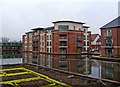
 Lichfield Basin. After two years it seems very few of the inhabitants utilise the mooring facilities. by Roger D Kidd – 29 May 2015")
 Lichfield Basin. After two years it seems very few of the inhabitants require the mooring facilities. by Roger D Kidd – 29 May 2015")


 Ltd, Lichfield Street, Stourport by Jeff Gogarty – 13 January 2018")


 dates from about 1800. Beyond that, the two storey building (Nos 5 and 6) date from about 1820 and is all that is left of a longer terrace.[[[4763838]]] by Roger D Kidd – 29 May 2015")

There is no page on Wikipedia called “Lichfield Basin, Stourport”
Wikipedia pages that might relate to Lichfield Basin, Stourport
[Horseley Fields Junction]
Anglesey Basin on the edge of Chasewater Reservoir. The only locks on this canal were the 30 that descended from Ogley Junction through Lichfield to Huddlesford
[A roads in Zone 4 of the Great Britain numbering scheme]
A38 when the eastern bypass was complete, rest is now Stoke Road. A4025 Stourport-on-Severn A449 A4026 Sutton Coldfield Little Aston Known as Little
[Bromsgrove railway station]
Street and Lichfield Trent Valley from 29 July 2018. Three trains per hour operate each way on weekdays, one to Four Oaks, one to Lichfield City and the
[Redditch railway station]
Lichfield City and one to Lichfield Trent Valley, all running via Birmingham New Street. On Sundays a half hourly service runs through to Lichfield Trent
[Barnt Green railway station]
extension of the recently commissioned Birmingham Cross-City Line from Lichfield City. This frequency was increased to half-hourly in 1989 and in 1992
Results of Google Search
77632 Unlock Stourport's BasinsStourport narrow boat locks opened. Clock Basin opened. 1806. Engine house and basin commissioned and Lichfield. Basin opened. 1812. Cheapside Basin ...
Project 1.1: Former Lichfield Basin - Project Specification. Project 1.2: Clock ... Forest District Council, to prepare a regeneration strategy for Stourport on Severn .
Lower Basin. Shipley's fairground. Upper Basin. Lichfield Basin. The Tontine. Clock. Basin. A4. 51. High Street. Narrow locks. Stourport. Yacht Club. Wide locks .
Aug 26, 2014 ... We went through Stourport-on-Severn in the past few days. The basin area looks vibrant and full of boats. Because we arrived at around 4pm ...
Mar 23, 2019 ... Originally built in 1810 and surrounded by warehouses, the basin was ... This is 1 of 2 images, with title Lichfield Basin, Stourport in this square.
Mart Lane Overbridge & New Canal Basin, Stourport on Severn ... Redevelopment of the disused and infilled Lichfield basin in Stourport on Severn is being ...
Lichfield Basin This basin was abandoned and had been infilled. It has now been restored and is back in water, but at reduced size from the original.
Stourport's canal basin, with ... Stourport-on-Severn Civic Society; Elizabeth Turner ...... Foundry Street to the north; Lion Hill, Lichfield Street and Severn Lane .