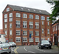
Canal and River Trust Office
is a minor waterways place
on the River Trent (non-tidal section) between
The Muskham Ferry (3 miles and 6 furlongs
and 1 lock
to the north) and
Fiskerton Wharf Visitor Moorings (7 miles and 2¼ furlongs
and 1 lock
to the west).
The nearest place in the direction of The Muskham Ferry is Cow Lane Footbridge;
1 furlong
away.
The nearest place in the direction of Fiskerton Wharf Visitor Moorings is Newark "The Kiln" Visitor Mooring Pontoon;
a few yards
away.
Mooring here is impossible (it may be physically impossible, forbidden, or allowed only for specific short-term purposes).
Nether Lock Weir Entrance | 6 furlongs | |
Newark Bypass Bridge | 5¾ furlongs | |
Newark Changeline Bridge | 4¾ furlongs | |
Kings Waterside & Marina | 1½ furlongs | |
Cow Lane Footbridge | 1 furlong | |
Canal and River Trust Office | ||
Newark "The Kiln" Visitor Mooring Pontoon | a few yards | |
Great North Road Bridge | 1¼ furlongs | |
Newark Castle | 1¾ furlongs | |
Newark Town Lock Weir Exit | 2¼ furlongs | |
Newark Town Lock No 9 | 2¾ furlongs |
Amenities nearby at Newark "The Kiln" Visitor Mooring Pontoon
Amenities nearby at Cow Lane Footbridge
There are no links to external websites from here.
Why not log in and add some (select "External websites" from the menu (sometimes this is under "Edit"))?
Mouseover for more information or show routes to facility
Nearest water point
In the direction of Wilford Toll Bridge
Newark "The Kiln" Visitor Mooring Pontoon — a few yards away
On this waterway in the direction of Wilford Toll Bridge
Hazelford Lock No 8 — 8 miles, 4¼ furlongs and 1 lock away
On this waterway in the direction of Wilford Toll Bridge
Gunthorpe Lock No 7 — 13 miles, 2½ furlongs and 2 locks away
On this waterway in the direction of Wilford Toll Bridge
Stoke Lock No 6 — 18 miles, ¼ furlongs and 3 locks away
On this waterway in the direction of Wilford Toll Bridge
In the direction of Cromwell Lock Weir Exit
Cromwell Lock Visitor Mooring Pontoon — 4 miles, 7½ furlongs and 1 lock away
On this waterway in the direction of Cromwell Lock Weir Exit
Cromwell Lock Weir Entrance — 5 miles and 1 lock away
On this waterway in the direction of Cromwell Lock Weir ExitNearest rubbish disposal
In the direction of Wilford Toll Bridge
Newark Town Lock No 9 — 2¾ furlongs away
On this waterway in the direction of Wilford Toll Bridge
Hazelford Lock No 8 — 8 miles, 4¼ furlongs and 1 lock away
On this waterway in the direction of Wilford Toll Bridge
Gunthorpe Lock No 7 — 13 miles, 2½ furlongs and 2 locks away
On this waterway in the direction of Wilford Toll Bridge
Stoke Lock No 6 — 18 miles, ¼ furlongs and 3 locks away
On this waterway in the direction of Wilford Toll Bridge
In the direction of Cromwell Lock Weir Exit
Cromwell Lock No 11 — 5 miles, 1 furlong and 1 lock away
On this waterway in the direction of Cromwell Lock Weir ExitNearest chemical toilet disposal
In the direction of Wilford Toll Bridge
Gunthorpe Lock No 7 — 13 miles, 2½ furlongs and 2 locks away
On this waterway in the direction of Wilford Toll Bridge
Stoke Lock No 6 — 18 miles, ¼ furlongs and 3 locks away
On this waterway in the direction of Wilford Toll Bridge
In the direction of Cromwell Lock Weir Exit
Nether Lock No 10 — 6¾ furlongs away
On this waterway in the direction of Cromwell Lock Weir Exit
Cromwell Lock No 11 — 5 miles, 1 furlong and 1 lock away
On this waterway in the direction of Cromwell Lock Weir ExitNearest place to turn
In the direction of Wilford Toll Bridge
Newark Town Lock Weir Exit — 2¼ furlongs away
On this waterway in the direction of Wilford Toll Bridge
Farndon Marina — 3 miles, 4¾ furlongs and 1 lock away
On this waterway in the direction of Wilford Toll Bridge
The Boathouse Pub Visitor Mooring — 3 miles, 5¾ furlongs and 1 lock away
On this waterway in the direction of Wilford Toll Bridge
Fiskerton Wharf Visitor Moorings — 7 miles, 2¼ furlongs and 1 lock away
On this waterway in the direction of Wilford Toll Bridge
Hazelford Lock East Weir Exit — 8 miles, 2½ furlongs and 1 lock away
On this waterway in the direction of Wilford Toll Bridge
Hazelford Lock Main Weir Exit — 8 miles, 3½ furlongs and 1 lock away
On this waterway in the direction of Wilford Toll Bridge
Hazelford Lock Main Weir Entrance — 8 miles, 5½ furlongs and 2 locks away
On this waterway in the direction of Wilford Toll Bridge
Hazelford Ferry — 9 miles, 1 furlong and 2 locks away
On this waterway in the direction of Wilford Toll Bridge
Hazelford Lock East Weir Entrance — 9 miles, 1¾ furlongs and 2 locks away
On this waterway in the direction of Wilford Toll Bridge
In the direction of Cromwell Lock Weir Exit
The Muskham Ferry — 3 miles, 6 furlongs and 1 lock away
On this waterway in the direction of Cromwell Lock Weir Exit
Cromwell Lock Visitor Mooring Pontoon — 4 miles, 7½ furlongs and 1 lock away
On this waterway in the direction of Cromwell Lock Weir Exit
Cromwell Lock Weir Entrance — 5 miles and 1 lock away
On this waterway in the direction of Cromwell Lock Weir ExitNearest boatyard pump-out
In the direction of Cromwell Lock Weir Exit
Kings Waterside & Marina — 1½ furlongs away
On this waterway in the direction of Cromwell Lock Weir ExitNo information
CanalPlan has no information on any of the following facilities within range:self-operated pump-out
Direction of TV transmitter (From Wolfbane Cybernetic)
There is no page on Wikipedia called “Canal and River Trust Office”
Wikipedia pages that might relate to Canal and River Trust Office
[Canal & River Trust]
The Canal & River Trust (CRT), branded as Glandŵr Cymru in Wales, holds the guardianship of 2,000 miles of canals and rivers, together with reservoirs
[Leeds and Liverpool Canal]
23 October 2021. "Leeds & Liverpool Canal". Canal & River Trust. Retrieved 30 December 2018. "Bridgewater Canal Leigh Branch – More Troubled Waters"
[Monmouthshire and Brecon Canal]
Publishing Co Ltd. ISBN 978-0-86190-327-6. "Monmouthshire & Brecon Canal". Canal and River Trust. Archived from the original on 24 February 2021. Retrieved 10
[Chesterfield Canal]
which cannot be restored. The eastern section is managed by the Canal and River Trust, while the western section is managed by Derbyshire County Council
[Montgomery Canal]
rest of the national Canal & River Trust network. Separately, a short stretch at Llanymynech and a central section of the canal around Welshpool are also
[British Waterways]
assets and responsibilities in England and Wales were transferred to the newly founded charity the Canal & River Trust. In Scotland, British Waterways continues
[List of navigation authorities in the United Kingdom]
Bridgewater Canal - Manchester Ship Canal Company in conjunction with the Bridgewater Canal Trust Bristol Harbour Authority The Canal & River Trust, formerly
[Caldon Canal]
Caldon and Uttoxeter Canal Trust. Archived from the original on 21 October 2017. Retrieved 15 November 2017. "Caldon Canal". Canal & River Trust. Archived
[Chesapeake and Ohio Canal]
Chesapeake and Ohio Canal, abbreviated as the C&O Canal and occasionally called the Grand Old Ditch, operated from 1831 until 1924 along the Potomac River between
[Chesapeake and Ohio Canal National Historical Park]
of the Chesapeake and Ohio Canal and many of its original structures. The canal and towpath trail extends along the Potomac River from the Georgetown