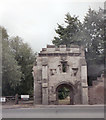
Somerton Road Railway Bridge (disused)
Llanthony Road, Gloucester GL2 5JH, United Kingdom
(A430)

Somerton Road Railway Bridge (disused)
is a minor waterways place
on the River Severn (old river navigation) between
Lower Parting (Junction with Maisemore Channel (closed)) (5½ furlongs
to the northwest) and
Gloucester / Sharpness - Severn Junction (Junction of Gloucester and Sharpness Canal with River Severn) (2¼ furlongs
to the northeast).
The nearest place in the direction of Lower Parting is Llanthony Lock Footbridge;
¼ furlongs
away.
The nearest place in the direction of Gloucester / Sharpness - Severn Junction is Somerton Road Bridge;
¼ furlongs
away.
Mooring here is unrated.
There is a bridge here which takes a disused railway over the canal.
| Elmore | 4 miles, ¼ furlongs | |
| Stonebench Turn | 3 miles, 5¼ furlongs | |
| Lower Parting | 5½ furlongs | |
| Llanthony Lock No 6 (closed) | ½ furlongs | |
| Llanthony Lock Footbridge | ¼ furlongs | |
| Somerton Road Railway Bridge (disused) | ||
| Somerton Road Bridge | ¼ furlongs | |
| Gloucester Dock Footbridge | 2 furlongs | |
| Gloucester / Sharpness - Severn Junction | 2¼ furlongs | |
There are no links to external websites from here.
Why not log in and add some (select "External websites" from the menu (sometimes this is under "Edit"))?
Mouseover for more information or show routes to facility
Nearest water point
In the direction of Gloucester / Sharpness - Severn Junction
Gloucester Dock Lock — 2½ furlongs away
Travel to Gloucester / Sharpness - Severn Junction, then on the Gloucester and Sharpness Canal to Gloucester Dock Lock
Gloucester Waterways Museum Arm — 3¼ furlongs and 1 lock away
Travel to Gloucester / Sharpness - Severn Junction, then on the Gloucester and Sharpness Canal to Gloucester Waterways Museum Arm
Llanthony Road Bridge — 3¾ furlongs and 1 lock away
Travel to Gloucester / Sharpness - Severn Junction, then on the Gloucester and Sharpness Canal to Llanthony Road Bridge
Llanthony Pontoons — 4½ furlongs and 1 lock away
Travel to Gloucester / Sharpness - Severn Junction, then on the Gloucester and Sharpness Canal to Llanthony Pontoons
Sellars Bridge — 4 miles, 2½ furlongs and 1 lock away
Travel to Gloucester / Sharpness - Severn Junction, then on the Gloucester and Sharpness Canal to Sellars Bridge
Saul Junction Winding Hole — 8 miles, 1 furlong and 1 lock away
Travel to Gloucester / Sharpness - Severn Junction, then on the Gloucester and Sharpness Canal to Saul Junction Winding Hole
Saul Junction Marina — 8 miles, 1¾ furlongs and 1 lock away
Travel to Gloucester / Sharpness - Severn Junction, then on the Gloucester and Sharpness Canal to Saul Junction, then on the Cotswold Canals (Stroudwater Navigation - Navigable Section) to Saul Junction Marina
Cotswold Canals Trust Visitor Centre - Saul Junction — 8 miles, 1¾ furlongs and 1 lock away
Travel to Gloucester / Sharpness - Severn Junction, then on the Gloucester and Sharpness Canal to Cotswold Canals Trust Visitor Centre - Saul Junction
Fretherne Bridge — 8 miles, 7 furlongs and 1 lock away
Travel to Gloucester / Sharpness - Severn Junction, then on the Gloucester and Sharpness Canal to Fretherne Bridge
Splatt Bridge — 9 miles, 7¾ furlongs and 1 lock away
Travel to Gloucester / Sharpness - Severn Junction, then on the Gloucester and Sharpness Canal to Splatt Bridge
Tewkesbury Lower Lode — 11 miles, 7¾ furlongs away
Travel to Gloucester / Sharpness - Severn Junction, then on the River Severn (main river - Worcester to Gloucester) to Tewkesbury Lower Lode
Patch Bridge — 11 miles, 6½ furlongs and 1 lock away
Travel to Gloucester / Sharpness - Severn Junction, then on the Gloucester and Sharpness Canal to Patch Bridge
Upper Lode Lock No 5 — 12 miles, 6 furlongs away
Travel to Gloucester / Sharpness - Severn Junction, then on the River Severn (main river - Worcester to Gloucester) to Upper Lode Lock No 5
Purton Lower Bridge — 14 miles, 2¼ furlongs and 1 lock away
Travel to Gloucester / Sharpness - Severn Junction, then on the Gloucester and Sharpness Canal to Purton Lower Bridge
Tewkesbury Services — 13 miles, 4 furlongs and 2 locks away
Travel to Gloucester / Sharpness - Severn Junction, then on the River Severn (main river - Worcester to Gloucester) to Tewkesbury Junction, then on the River Avon - Warwickshire (Lower Avon Navigation) to Tewkesbury Services
Bredon — 16 miles, 7¾ furlongs and 2 locks away
Travel to Gloucester / Sharpness - Severn Junction, then on the River Severn (main river - Worcester to Gloucester) to Tewkesbury Junction, then on the River Avon - Warwickshire (Lower Avon Navigation) to Bredon
Strensham Lock — 19 miles, ¼ furlongs and 2 locks away
Travel to Gloucester / Sharpness - Severn Junction, then on the River Severn (main river - Worcester to Gloucester) to Tewkesbury Junction, then on the River Avon - Warwickshire (Lower Avon Navigation) to Strensham LockNearest rubbish disposal
In the direction of Gloucester / Sharpness - Severn Junction
Llanthony Road Bridge — 3¾ furlongs and 1 lock away
Travel to Gloucester / Sharpness - Severn Junction, then on the Gloucester and Sharpness Canal to Llanthony Road Bridge
Sellars Bridge — 4 miles, 2½ furlongs and 1 lock away
Travel to Gloucester / Sharpness - Severn Junction, then on the Gloucester and Sharpness Canal to Sellars Bridge
Parkend Bridge — 6 miles, 4 furlongs and 1 lock away
Travel to Gloucester / Sharpness - Severn Junction, then on the Gloucester and Sharpness Canal to Parkend Bridge
Saul Junction Winding Hole — 8 miles, 1 furlong and 1 lock away
Travel to Gloucester / Sharpness - Severn Junction, then on the Gloucester and Sharpness Canal to Saul Junction Winding Hole
Saul Junction Marina — 8 miles, 1¾ furlongs and 1 lock away
Travel to Gloucester / Sharpness - Severn Junction, then on the Gloucester and Sharpness Canal to Saul Junction, then on the Cotswold Canals (Stroudwater Navigation - Navigable Section) to Saul Junction Marina
Fretherne Bridge — 8 miles, 7 furlongs and 1 lock away
Travel to Gloucester / Sharpness - Severn Junction, then on the Gloucester and Sharpness Canal to Fretherne Bridge
Splatt Bridge — 9 miles, 7¾ furlongs and 1 lock away
Travel to Gloucester / Sharpness - Severn Junction, then on the Gloucester and Sharpness Canal to Splatt Bridge
Patch Bridge — 11 miles, 6½ furlongs and 1 lock away
Travel to Gloucester / Sharpness - Severn Junction, then on the Gloucester and Sharpness Canal to Patch Bridge
Purton Lower Bridge — 14 miles, 2¼ furlongs and 1 lock away
Travel to Gloucester / Sharpness - Severn Junction, then on the Gloucester and Sharpness Canal to Purton Lower Bridge
Tewkesbury Services — 13 miles, 4 furlongs and 2 locks away
Travel to Gloucester / Sharpness - Severn Junction, then on the River Severn (main river - Worcester to Gloucester) to Tewkesbury Junction, then on the River Avon - Warwickshire (Lower Avon Navigation) to Tewkesbury Services
Sharpness Barge Arm — 15 miles, 5½ furlongs and 1 lock away
Travel to Gloucester / Sharpness - Severn Junction, then on the Gloucester and Sharpness Canal to Sharpness Barge ArmNearest chemical toilet disposal
In the direction of Gloucester / Sharpness - Severn Junction
Llanthony Road Bridge — 3¾ furlongs and 1 lock away
Travel to Gloucester / Sharpness - Severn Junction, then on the Gloucester and Sharpness Canal to Llanthony Road Bridge
Saul Junction Marina — 8 miles, 1¾ furlongs and 1 lock away
Travel to Gloucester / Sharpness - Severn Junction, then on the Gloucester and Sharpness Canal to Saul Junction, then on the Cotswold Canals (Stroudwater Navigation - Navigable Section) to Saul Junction Marina
Cotswold Canals Trust Visitor Centre - Saul Junction — 8 miles, 1¾ furlongs and 1 lock away
Travel to Gloucester / Sharpness - Severn Junction, then on the Gloucester and Sharpness Canal to Cotswold Canals Trust Visitor Centre - Saul Junction
Sharpness Barge Arm — 15 miles, 5½ furlongs and 1 lock away
Travel to Gloucester / Sharpness - Severn Junction, then on the Gloucester and Sharpness Canal to Sharpness Barge ArmNearest place to turn
In the direction of Gloucester / Sharpness - Severn Junction
Gloucester / Sharpness - Severn Junction — 2¼ furlongs away
On this waterway in the direction of Gloucester / Sharpness - Severn Junction
Waterways Office (South Wales and Severn Waterways) - Canal & River Trust — 2¾ furlongs and 1 lock away
Travel to Gloucester / Sharpness - Severn Junction, then on the Gloucester and Sharpness Canal to Waterways Office (South Wales and Severn Waterways) - Canal & River Trust
Gloucester Docks — 3 furlongs and 1 lock away
Travel to Gloucester / Sharpness - Severn Junction, then on the Gloucester and Sharpness Canal to Gloucester Docks
Monk Meadow Dock — 7 furlongs and 1 lock away
Travel to Gloucester / Sharpness - Severn Junction, then on the Gloucester and Sharpness Canal to Monk Meadow Dock
Upper Parting Junction — 2 miles, 7 furlongs away
Travel to Gloucester / Sharpness - Severn Junction, then on the River Severn (main river - Worcester to Gloucester) to Upper Parting Junction
Quedgeley Oil Depot — 4 miles, 1¼ furlongs and 1 lock away
Travel to Gloucester / Sharpness - Severn Junction, then on the Gloucester and Sharpness Canal to Quedgeley Oil Depot
Pegthorne Bridge Winding Hole — 7 miles, 3¾ furlongs and 1 lock away
Travel to Gloucester / Sharpness - Severn Junction, then on the Gloucester and Sharpness Canal to Pegthorne Bridge Winding Hole
Saul Junction Winding Hole — 8 miles, 1 furlong and 1 lock away
Travel to Gloucester / Sharpness - Severn Junction, then on the Gloucester and Sharpness Canal to Saul Junction Winding Hole
Upper Lode Lock Weir Exit — 12 miles, 4 furlongs away
Travel to Gloucester / Sharpness - Severn Junction, then on the River Severn (main river - Worcester to Gloucester) to Upper Lode Lock Weir Exit
Upper Lode Lock Weir Entrance — 12 miles, 7 furlongs and 1 lock away
Travel to Gloucester / Sharpness - Severn Junction, then on the River Severn (main river - Worcester to Gloucester) to Upper Lode Lock Weir Entrance
Avon Lock Junction — 13 miles, 3¾ furlongs and 2 locks away
Travel to Gloucester / Sharpness - Severn Junction, then on the River Severn (main river - Worcester to Gloucester) to Tewkesbury Junction, then on the River Avon - Warwickshire (Lower Avon Navigation) to Avon Lock Junction
Abbey Mill Tewkesbury — 13 miles, 4¾ furlongs and 2 locks away
Travel to Gloucester / Sharpness - Severn Junction, then on the River Severn (main river - Worcester to Gloucester) to Tewkesbury Junction, then on the River Avon - Warwickshire (Lower Avon Navigation) to Avon Lock Junction, then on the River Avon - Warwickshire (Mill Avon) to Abbey Mill Tewkesbury
Tewkesbury Marina Entrance No 2 — 13 miles, 7¾ furlongs and 2 locks away
Travel to Gloucester / Sharpness - Severn Junction, then on the River Severn (main river - Worcester to Gloucester) to Tewkesbury Junction, then on the River Avon - Warwickshire (Lower Avon Navigation) to Tewkesbury Marina Entrance No 2
Sharpness Barge Arm — 15 miles, 5½ furlongs and 1 lock away
Travel to Gloucester / Sharpness - Severn Junction, then on the Gloucester and Sharpness Canal to Sharpness Barge Arm
The Ocean — 11 miles, 7¼ furlongs and 9 locks away
Travel to Gloucester / Sharpness - Severn Junction, then on the Gloucester and Sharpness Canal to Saul Junction, then on the Cotswold Canals (Stroudwater Navigation - Navigable Section) to Walk Bridge, then on the Cotswold Canals (Stroudwater Navigation - Un-navigable Section) to The Ocean
Ryeford Winding Hole — 12 miles, 7 furlongs and 9 locks away
Travel to Gloucester / Sharpness - Severn Junction, then on the Gloucester and Sharpness Canal to Saul Junction, then on the Cotswold Canals (Stroudwater Navigation - Navigable Section) to Walk Bridge, then on the Cotswold Canals (Stroudwater Navigation - Un-navigable Section) to Ryeford Winding Hole
Brimscombe Port — 17 miles, 5½ furlongs and 20 locks away
Travel to Gloucester / Sharpness - Severn Junction, then on the Gloucester and Sharpness Canal to Saul Junction, then on the Cotswold Canals (Stroudwater Navigation - Navigable Section) to Walk Bridge, then on the Cotswold Canals (Stroudwater Navigation - Un-navigable Section) to Site of Entrance to Wallbridge Basin, then on the Cotswold Canals (Thames and Severn Canal - Wide section) to Brimscombe Port
In the direction of Sharpness Junction
Over Winding Hole — 1 mile, 5½ furlongs and 1 lock away
Travel to Lower Parting, then on the River Severn (Maisemore Channel - Southern Section) to Over Junction, then on the Hereford and Gloucester Canal to Over Winding HoleNearest self-operated pump-out
In the direction of Gloucester / Sharpness - Severn Junction
Llanthony Pontoons — 4½ furlongs and 1 lock away
Travel to Gloucester / Sharpness - Severn Junction, then on the Gloucester and Sharpness Canal to Llanthony Pontoons
Cotswold Canals Trust Visitor Centre - Saul Junction — 8 miles, 1¾ furlongs and 1 lock away
Travel to Gloucester / Sharpness - Severn Junction, then on the Gloucester and Sharpness Canal to Cotswold Canals Trust Visitor Centre - Saul Junction
Purton Lower Bridge — 14 miles, 2¼ furlongs and 1 lock away
Travel to Gloucester / Sharpness - Severn Junction, then on the Gloucester and Sharpness Canal to Purton Lower BridgeNearest boatyard pump-out
In the direction of Gloucester / Sharpness - Severn Junction
Saul Junction Marina — 8 miles, 1¾ furlongs and 1 lock away
Travel to Gloucester / Sharpness - Severn Junction, then on the Gloucester and Sharpness Canal to Saul Junction, then on the Cotswold Canals (Stroudwater Navigation - Navigable Section) to Saul Junction Marina
Patch Bridge — 11 miles, 6½ furlongs and 1 lock away
Travel to Gloucester / Sharpness - Severn Junction, then on the Gloucester and Sharpness Canal to Patch BridgeDirection of TV transmitter (From Wolfbane Cybernetic)
There is no page on Wikipedia called “Somerton Road Railway Bridge”
Wikipedia pages that might relate to Somerton Road Railway Bridge
[Fritwell & Somerton railway station]
but the road journey was about 5 miles (8 km). It was soon decided that Somerton needed a station. It was built south of the railway bridge in the village
[List of bridge failures]
"Inquiry reports on Vietnam's Can Tho Bridge collapse". Chamberlain, Simon (8 December 2008). "Somerton Bridge closed indefinitely". Northern Daily Leader
[Upfield railway line]
strong resistance from the Railways Commissioners, the state government ordered the reopening of the section from Fawkner to Somerton for passengers. Services
[List of railway bridges and viaducts in the United Kingdom]
significant bridges of the United Kingdom's railways, past and present. Contents: Top 0–9 A B C D E F G H I J K L M N O P Q R S T U V W X Y Z List of bridges in
[Cowes]
Technologies (Insyte), which occupies the site of the old Somerton Aerodrome at Newport Road, Cowes; and GKN Aerospace in East Cowes. The population of
[River Great Ouse]
flows 5 miles (8 km) northwest to join the western twin, which starts near Somerton in Oxfordshire. From here it flows due East, through Fewcott, Stoke Lyne
[Clyde Engineering]
locomotive". Tasmanian Railway News. 237: 13–15. "Peats Ferry Road Bridge over Hawkesbury River". Heritage and conservation register, Roads & Maritime Services
[Somerton, Oxfordshire]
stands, and a bridge carries it over the road to North Aston. The GWR opened a station just south of the bridge in 1855; originally named Somerton, it was renamed
[Oxford Rewley Road railway station]
Oxford Rewley Road railway station was a railway station serving the city of Oxford, England, located immediately to the north of what is now Frideswide
[Freight railways in Melbourne]
of other railway stations have freight facilities still in use: Somerton Lyndhurst Westall Kensington In the late 1920s, the Victorian Railways introduced
Results of Google Search
Nov 7, 2017 ... Over the weekend (4 & 5 November 2017), we removed an old railway bridge in Tottenham as part of our £170m Lee Valley Rail programme to ...
Disused railway stations in the United Kingdom. Closed railway stations in Britain A B C D–F G H–J K–L M–O P–R S T–V W–Z. Fritwell & Somerton railway station was on the Oxford to Banbury line of the Great Western ... closer by rail, being about 2.5 miles (4 km) to the north, but the road journey was about 5 miles (8 km).
Jun 6, 2017 ... East Somerton church Norfolk explorered very taken any nature left to rot, east sumerton can be found on google and the story of the witch.
Somerton railway station was a small railway station situated on the Great Western Railway's ... Disused railway stations in the United Kingdom ... The station lay just behind the West Street girder bridge and ran all the way down to the Perry ...
Underside of the Somerton Road bridge - steel spans bolted together ... Disused standard gauge Martin Bright Steel siding at Somerton. 30 August 2009 12:28 ...
Nov 2, 2015 ... The road runs over the South Wales Main Line railway and connects Liswerry and. Alway via Somerton Road Bridge. Originally built in 1846, ...
Old Kent Road was a railway station on the London, Brighton and South Coast Railway line in south London which took its name from the Old Kent Road on ...
See departure times for every stop on this bus route. ... Bolton Street / East Lancs Railway (Stop SS) · Elton, Crostons Road / opposite Bury Bridge ... Ainsworth, Bury Old Road / outside Red Bridge · Withins, Red Lane / opposite Foster ... Bury Road / opposite Falkland Road · Breightmet, Somerton Road / opposite Honiton ...


![Brick and stone. Some of the ruins still remaining of Llantony Secunda Priory. See [[[3576866]]] for a closer look at the change of materials. by Neil Owen – 19 June 2013](https://s3.geograph.org.uk/geophotos/03/57/68/3576855_c7ac8471_120x120.jpg)
![Stone, brick and prayer. The remains of Llanthony priory, showing how the builders combined different materials. See [[[3576810]]] for another view. by Neil Owen – 19 June 2013](https://s2.geograph.org.uk/geophotos/03/57/68/3576866_24bc4d21_120x120.jpg)


![West face of the priory buildings. Established in the twelfth century and rebuilt in subsequent times, with additions of a more modern type. See [[[3576848]]] for more around this site. by Neil Owen – 19 June 2013](https://s0.geograph.org.uk/geophotos/03/57/68/3576844_18b1c42b_120x120.jpg)
![Not boarded up. But it will keep the wildlife out. See [[[3576855]]] for another detail of the old priory. by Neil Owen – 19 June 2013](https://s0.geograph.org.uk/geophotos/03/57/68/3576848_77369d15_120x120.jpg)