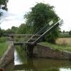
Shipton Lift Bridge No 219
Saint Giles', Jerome Way, Cherwell OX5 1JT, United Kingdom
Address is taken from a point 339 yards away.

Shipton Lift Bridge No 219
is a minor waterways place
on the Oxford Canal (Southern Section - Main Line) between
Sparrowgap Bridge No 223 (1 mile and 1½ furlongs
to the southwest) and
Railway Bridge over River Cherwell No 217A (7¼ furlongs
and 1 lock
to the northwest).
The nearest place in the direction of Sparrowgap Bridge No 223 is Shipton Railway Bridge;
½ furlongs
away.
The nearest place in the direction of Railway Bridge over River Cherwell No 217A is Shipton Weir Bridge No 218;
2¼ furlongs
away.
Mooring here is unrated.
There is a lift bridge here. The bridge is normally left open.
| Annie's Tea Rooms | 6 furlongs | |
| Thrupp Wide | 6 furlongs | |
| Thrupp Cruising Club | 6 furlongs | |
| Shipton Bridge No 220 | 2¾ furlongs | |
| Shipton Railway Bridge | ½ furlongs | |
| Shipton Lift Bridge No 219 | ||
| Shipton Weir Bridge No 218 | 2¼ furlongs | |
| Shipton Weir Lock No 41 | 2¼ furlongs | |
| Shipton Weir Junction | 2½ furlongs | |
| Railway Bridge over River Cherwell No 217A | 7¼ furlongs | |
| Horse Bridge Junction | 1 mile, ½ furlongs | |
- Oxford Canal Walk - Part One - Oxford to Thrupp - YouTube — associated with Oxford Canal
- A walk along the Oxford Canal (Southern Section) from Oxford to Thrupp Wide
Mouseover for more information or show routes to facility
Nearest water point
In the direction of Napton Junction
Heyford Wharf Bridge No 206 — 6 miles, 6¼ furlongs and 5 locks away
On this waterway in the direction of Napton Junction
Heyford Wharf — 6 miles, 6½ furlongs and 5 locks away
On this waterway in the direction of Napton Junction
Aynho Wharf — 12 miles, 6¾ furlongs and 8 locks away
On this waterway in the direction of Napton Junction
Cherwell Street Facilities — 19 miles, 4½ furlongs and 12 locks away
On this waterway in the direction of Napton Junction
Banbury Lock No 29 — 19 miles, 4¾ furlongs and 12 locks away
On this waterway in the direction of Napton Junction
Sovereign Wharf — 19 miles, 6¾ furlongs and 13 locks away
On this waterway in the direction of Napton Junction
In the direction of End of Hythe Bridge Arm
Thrupp Cruising Club — 6 furlongs away
On this waterway in the direction of End of Hythe Bridge Arm
Aubreys Lift Bridge No 221 — 6¼ furlongs away
On this waterway in the direction of End of Hythe Bridge Arm
Langford Lane Bridge No 224 — 1 mile, 3½ furlongs away
On this waterway in the direction of End of Hythe Bridge Arm
Wolvercote Junction Water Point — 4 miles, 3¼ furlongs and 2 locks away
On this waterway in the direction of End of Hythe Bridge Arm
Wolvercote Sanitary Station — 4 miles, 7¾ furlongs and 3 locks away
On this waterway in the direction of End of Hythe Bridge Arm
St Edwards Lift Bridge No 238 — 6 miles, ½ furlongs and 4 locks away
On this waterway in the direction of End of Hythe Bridge Arm
Oxford Visitor Moorings — 7 miles, 4¾ furlongs and 4 locks away
On this waterway in the direction of End of Hythe Bridge Arm
Eynsham Lock — 7 miles, 7 furlongs and 4 locks away
Travel to Wolvercote Junction, then on the Oxford Canal (Duke's Cut) to Duke's Cut Junction, then on the River Thames (above Oxford) to Eynsham Lock
Abingdon Lock — 16 miles, 3¾ furlongs and 8 locks away
Travel to Isis Lock Junction, then on the River Thames (Sheepwash Channel) to Sheepwash Channel Junction, then on the River Thames (above Oxford) to Osney Bridge, then on the River Thames (below Oxford) to Abingdon Lock
Shifford Lock — 17 miles, 7¾ furlongs and 7 locks away
Travel to Wolvercote Junction, then on the Oxford Canal (Duke's Cut) to Duke's Cut Junction, then on the River Thames (above Oxford) to Shifford Lock
Abingdon Bridge Marine — 16 miles, 7½ furlongs and 9 locks away
Travel to Isis Lock Junction, then on the River Thames (Sheepwash Channel) to Sheepwash Channel Junction, then on the River Thames (above Oxford) to Osney Bridge, then on the River Thames (below Oxford) to Abingdon Bridge MarineNearest rubbish disposal
In the direction of Napton Junction
Heyford Wharf Bridge No 206 — 6 miles, 6¼ furlongs and 5 locks away
On this waterway in the direction of Napton Junction
Heyford Wharf — 6 miles, 6½ furlongs and 5 locks away
On this waterway in the direction of Napton Junction
Aynho Wharf — 12 miles, 6¾ furlongs and 8 locks away
On this waterway in the direction of Napton Junction
Cherwell Street Facilities — 19 miles, 4½ furlongs and 12 locks away
On this waterway in the direction of Napton Junction
Sovereign Wharf — 19 miles, 6¾ furlongs and 13 locks away
On this waterway in the direction of Napton Junction
In the direction of End of Hythe Bridge Arm
Thrupp Cruising Club — 6 furlongs away
On this waterway in the direction of End of Hythe Bridge Arm
Aubreys Lift Bridge No 221 — 6¼ furlongs away
On this waterway in the direction of End of Hythe Bridge Arm
Wolvercote Sanitary Station — 4 miles, 7¾ furlongs and 3 locks away
On this waterway in the direction of End of Hythe Bridge Arm
Eynsham Lock — 7 miles, 7 furlongs and 4 locks away
Travel to Wolvercote Junction, then on the Oxford Canal (Duke's Cut) to Duke's Cut Junction, then on the River Thames (above Oxford) to Eynsham Lock
Abingdon Lock — 16 miles, 3¾ furlongs and 8 locks away
Travel to Isis Lock Junction, then on the River Thames (Sheepwash Channel) to Sheepwash Channel Junction, then on the River Thames (above Oxford) to Osney Bridge, then on the River Thames (below Oxford) to Abingdon LockNearest chemical toilet disposal
In the direction of Napton Junction
Cherwell Street Facilities — 19 miles, 4½ furlongs and 12 locks away
On this waterway in the direction of Napton Junction
Sovereign Wharf — 19 miles, 6¾ furlongs and 13 locks away
On this waterway in the direction of Napton Junction
In the direction of End of Hythe Bridge Arm
Thrupp Cruising Club — 6 furlongs away
On this waterway in the direction of End of Hythe Bridge Arm
Wolvercote Sanitary Station — 4 miles, 7¾ furlongs and 3 locks away
On this waterway in the direction of End of Hythe Bridge Arm
Eynsham Lock — 7 miles, 7 furlongs and 4 locks away
Travel to Wolvercote Junction, then on the Oxford Canal (Duke's Cut) to Duke's Cut Junction, then on the River Thames (above Oxford) to Eynsham Lock
Abingdon Lock — 16 miles, 3¾ furlongs and 8 locks away
Travel to Isis Lock Junction, then on the River Thames (Sheepwash Channel) to Sheepwash Channel Junction, then on the River Thames (above Oxford) to Osney Bridge, then on the River Thames (below Oxford) to Abingdon LockNearest place to turn
In the direction of Napton Junction
Shipton Weir Junction — 2½ furlongs and 1 lock away
On this waterway in the direction of Napton Junction
Enslow Winding Hole — 1 mile, 6¾ furlongs and 2 locks away
On this waterway in the direction of Napton Junction
Kirtlington Winding Hole — 3 miles, 4 furlongs and 3 locks away
On this waterway in the direction of Napton Junction
The Cleeves Winding Hole — 6 miles, 2½ furlongs and 5 locks away
On this waterway in the direction of Napton Junction
Heyford Wharf — 6 miles, 6½ furlongs and 5 locks away
On this waterway in the direction of Napton Junction
Heyford Wharf Winding Hole — 6 miles, 6½ furlongs and 5 locks away
On this waterway in the direction of Napton Junction
In the direction of End of Hythe Bridge Arm
Thrupp Wide — 6 furlongs away
On this waterway in the direction of End of Hythe Bridge Arm
Wolvercote Junction — 4 miles, 4¼ furlongs and 3 locks away
On this waterway in the direction of End of Hythe Bridge Arm
Bypass Reservoir Junction — 4 miles, 6 furlongs and 4 locks away
Travel to Wolvercote Junction, then on the Oxford Canal (Duke's Cut) to Bypass Reservoir Junction
Duke's Cut Junction — 5 miles, 2½ furlongs and 4 locks away
Travel to Wolvercote Junction, then on the Oxford Canal (Duke's Cut) to Duke's Cut Junction
Hythe Bridge Arm Winding Hole — 7 miles, 4 furlongs and 4 locks away
On this waterway in the direction of End of Hythe Bridge Arm
End of Hythe Bridge Arm — 7 miles, 5 furlongs and 4 locks away
On this waterway in the direction of End of Hythe Bridge Arm
Thames - Wharf Stream Junction — 7 miles, 5¼ furlongs and 4 locks away
Travel to Wolvercote Junction, then on the Oxford Canal (Duke's Cut) to Duke's Cut Junction, then on the River Thames (above Oxford) to Thames - Wharf Stream Junction
Castle Mill Stream Junction — 7 miles, 4½ furlongs and 5 locks away
Travel to Isis Lock Junction, then on the River Thames (Sheepwash Channel) to Castle Mill Stream Junction
Sheepwash Channel Junction — 7 miles, 5¼ furlongs and 5 locks away
Travel to Isis Lock Junction, then on the River Thames (Sheepwash Channel) to Sheepwash Channel Junction
Bossoms Boat Yard — 7 miles, 7¾ furlongs and 6 locks away
Travel to Wolvercote Junction, then on the Oxford Canal (Duke's Cut) to Duke's Cut Junction, then on the River Thames (above Oxford) to Bossoms Boat Yard
Osney Lock Weir Exit — 8 miles and 6 locks away
Travel to Isis Lock Junction, then on the River Thames (Sheepwash Channel) to Sheepwash Channel Junction, then on the River Thames (above Oxford) to Osney Bridge, then on the River Thames (below Oxford) to Osney Lock Weir Exit
Pinkhill Lock Weir Exit — 9 miles, 1¼ furlongs and 5 locks away
Travel to Wolvercote Junction, then on the Oxford Canal (Duke's Cut) to Duke's Cut Junction, then on the River Thames (above Oxford) to Pinkhill Lock Weir Exit
Thames - Cherwell Junction — 9 miles, 2¼ furlongs and 6 locks away
Travel to Isis Lock Junction, then on the River Thames (Sheepwash Channel) to Sheepwash Channel Junction, then on the River Thames (above Oxford) to Osney Bridge, then on the River Thames (below Oxford) to Thames - Cherwell Junction
Iffley Lock Weir Entrance No 1 — 10 miles, 1½ furlongs and 6 locks away
Travel to Isis Lock Junction, then on the River Thames (Sheepwash Channel) to Sheepwash Channel Junction, then on the River Thames (above Oxford) to Osney Bridge, then on the River Thames (below Oxford) to Iffley Lock Weir Entrance No 1Nearest self-operated pump-out
In the direction of End of Hythe Bridge Arm
Thrupp Cruising Club — 6 furlongs away
On this waterway in the direction of End of Hythe Bridge Arm
Aubreys Lift Bridge No 221 — 6¼ furlongs away
On this waterway in the direction of End of Hythe Bridge Arm
Eynsham Lock — 7 miles, 7 furlongs and 4 locks away
Travel to Wolvercote Junction, then on the Oxford Canal (Duke's Cut) to Duke's Cut Junction, then on the River Thames (above Oxford) to Eynsham Lock
Abingdon Lock — 16 miles, 3¾ furlongs and 8 locks away
Travel to Isis Lock Junction, then on the River Thames (Sheepwash Channel) to Sheepwash Channel Junction, then on the River Thames (above Oxford) to Osney Bridge, then on the River Thames (below Oxford) to Abingdon LockNearest boatyard pump-out
In the direction of Napton Junction
Enslow Wharf — 1 mile, 5½ furlongs and 2 locks away
On this waterway in the direction of Napton Junction
Heyford Wharf — 6 miles, 6½ furlongs and 5 locks away
On this waterway in the direction of Napton Junction
Aynho Wharf — 12 miles, 6¾ furlongs and 8 locks away
On this waterway in the direction of Napton Junction
Twyford Wharf — 16 miles, 6 furlongs and 11 locks away
On this waterway in the direction of Napton Junction
Sovereign Wharf — 19 miles, 6¾ furlongs and 13 locks away
On this waterway in the direction of Napton Junction
In the direction of End of Hythe Bridge Arm
Oxford Cruisers Marina — 8 miles, 6¾ furlongs and 5 locks away
Travel to Wolvercote Junction, then on the Oxford Canal (Duke's Cut) to Duke's Cut Junction, then on the River Thames (above Oxford) to Oxford Cruisers Marina
Abingdon Bridge Marine — 16 miles, 7½ furlongs and 9 locks away
Travel to Isis Lock Junction, then on the River Thames (Sheepwash Channel) to Sheepwash Channel Junction, then on the River Thames (above Oxford) to Osney Bridge, then on the River Thames (below Oxford) to Abingdon Bridge MarineDirection of TV transmitter (From Wolfbane Cybernetic)
There is no page on Wikipedia called “Shipton Lift Bridge”
Wikipedia pages that might relate to Shipton Lift Bridge
[Tay Bridge disaster]
two of the high girders fell when being lifted into place in February 1877. The first engine crossed the bridge in September, 1877. A Board of Trade inspection
[Shipton-on-Cherwell Halt railway station]
Shipton-on-Cherwell Halt was a railway halt constructed in 1929 by the Great Western Railway to serve the Oxfordshire village of Shipton-on-Cherwell as
[A Clockwork Orange (film)]
with the footbridge over the pond is Milton Grundy's Japanese garden in Shipton-under-Wychwood, Oxfordshire and the interior is Skybreak House in The Warren
[Crickhowell]
moderngov.co.uk (in Welsh). 22 July 2019. Retrieved 22 July 2019. Martin Shipton (7 August 2008) "Cafe war breaks out over market hall", Wales Online. Retrieved
[Oxford Canal]
possible. Many economy measures were used. Wherever possible, wooden lift or swing bridges were built instead of expensive brick ones. Deep locks were used
[Double bass]
Octobass Triple contrabass viol Piccolo bass Tololoche Slatford, Rodney; Shipton, Alyn (2001). "Double bass". Oxford Music Online: Grove Music Online. doi:10
[Characters of Casualty]
Duffin, played by Cathy Shipton, is one of the show's original characters and is a senior ward sister and senior midwife. Shipton revealed in 2016 that
[United States Army Europe and Africa]
Missile Defense Command 5th Battalion, 4th Air Defence Artillery Regiment, Shipton Kaserne 21st Theater Sustainment Command 266th Financial Management Support
[Famine]
Deprivation, Oxford, Clarendon Press, 1982 via Questia via Oxford Press Shipton, Parker (1990). "African Famines and Food Security: Anthropological Perspectives"
[Kingham railway station]
of Oxford) on 4 June 1853, there was no station between Adlestrop and Shipton. On 10 August 1855 a branch line to Chipping Norton was opened by the Chipping
Results of Google Search
Time-lapse Narrowboat trip - Shipton on Cherwell lift bridge to ...May 21, 2015 ... A time-lapse narrowboat journey on the Oxford canal. Starting near Shipton on Cherwell lift bridge No 219 to Roundham Lock in Kidlington.
Dec 20, 2015 ... This is a very dangerous lift-bridge (No 219) near Shipton on Cherwell, on the South Oxford Canal. It desperately needs more counterweights ...
#x200b;A short distance further on we approach the Shipton Lift Bridge (No. 219). The bridge is of a type which is almost unique to the Oxford canal. Lift Bridges were ...
Oct 9, 2005 ... No higher resolution available. ... Attribution (required by the license), Michel Van den Berghe / Lift Bridge 219 seen from the South. / CC BY-SAÂ ...
Dec 7, 2016 ... 219) near Shipton on Cherwell; Caravan lift bridge (no. 215) near Enslow; Haddons lift bridge (no. 173) near Banbury. Charles Baker, from the ...
141, Boundary Lift Bridge. Wormleighton Reservoir. canal feeder ... Shipton Weir Lock No 41. 219, Shipton Lift Bridge. Shipton Railway Bridge. 221, Aubreys Lift ...
Factory Street Lift Bridge 164 is a pedestrian bridge requiring hand winding to lift ... There's no conflict of interest between youth and ... Shipton Lift Bridge 219.
The Oxford Canal is a 78-mile (126 km) narrow canal in central England linking Oxford with ... Hawkesbury Stop Lock No.1 ... 219, Shipton Lift Bridge ... A stretch of the River Cherwell at Shipton-on-Cherwell was incorporated into the canal.
Aug 27, 2014 ... We had been warned that Shipton Lift Bridge 219 was unbalanced and hard to open but as we arrived a boat coming the other way had ...


![Bridge No. 219 in open position. This lifting bridge carries a footpath and has been opened to allow the passage of a boat. A windlass is used on the towpath side to operate a piston which can just be seen under the deck of the bridge. Compare [[8068355]]. by David Martin – 04 June 2025](https://s0.geograph.org.uk/geophotos/08/06/83/8068352_7a6b1d1c_120x120.jpg)
![Bridge No. 219 in closed position. A narrowboat has just passed and the bridge has been lowered again to restore the footpath link. Compare [[8068352]]. by David Martin – 04 June 2025](https://s3.geograph.org.uk/geophotos/08/06/83/8068355_7ed2d2a0_120x120.jpg)


![The Oxford Canal at Shipton-on-Cherwell. Viewed from a passing train. To the right is the abutment of a former railway bridge. [[6541234]] taken the previous year shows the same view from the oppsoite direction, and gives more history of the railway. by Stephen Craven – 21 September 2021](https://s2.geograph.org.uk/geophotos/07/09/97/7099770_c61d0126_120x120.jpg)