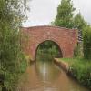
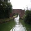
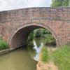
Hay Bridge No 143
is a minor waterways place
on the Oxford Canal (Southern Section - Main Line) between
Cropredy Wharf Bridge No 153 (Cropredy) (3 miles and 3¼ furlongs
and 9 locks
to the south) and
Fenny Compton Wharf (2 miles and 7 furlongs
to the northwest).
The nearest place in the direction of Cropredy Wharf Bridge No 153 is Claydon Top Lock Bridge No 144;
4¼ furlongs
away.
The nearest place in the direction of Fenny Compton Wharf is Feeder Bridge No 142 (The bridge is a towpath bridge over the feeder from Boddington Reservoir.);
2 furlongs
away.
There is access (suitable for wheels) to the towpath here.
Mooring here is unrated.
There is a bridge here which takes a minor road over the canal.
Claydon Lock Bridge No 145 | 7¼ furlongs | |
Claydon Lock No 19 | 7¼ furlongs | |
Claydon Lock No 18 | 5¾ furlongs | |
Claydon Top Lock No 17 | 5 furlongs | |
Claydon Top Lock Bridge No 144 | 4¼ furlongs | |
Hay Bridge No 143 | ||
Feeder Bridge No 142 | 2 furlongs | |
Boundary Lift Bridge No 141 | 4¾ furlongs | |
Site of Wormleighton Railway Bridge (narrows) | 7 furlongs | |
Wormleighton Reservoir Bridge No 139 | 1 mile, 1 furlong | |
Fenny Compton 'Tunnel' (eastern entrance) | 1 mile, 4 furlongs |
- Oxford Canal Walk - Part One - Oxford to Thrupp - YouTube — associated with Oxford Canal
- A walk along the Oxford Canal (Southern Section) from Oxford to Thrupp Wide
Mouseover for more information or show routes to facility
Nearest water point
In the direction of Napton Junction
Fenny Compton Wharf — 2 miles, 7 furlongs away
On this waterway in the direction of Napton Junction
Marston Doles Water Point — 10 miles, 2¾ furlongs away
On this waterway in the direction of Napton Junction
Water Point at Bottom of Napton Locks — 12 miles, 3 furlongs and 9 locks away
On this waterway in the direction of Napton Junction
Wigrams Turn Marina — 14 miles, 3¼ furlongs and 9 locks away
Travel to Napton Junction, then on the Grand Union Canal (Oxford Canal Section) to Wigrams Turn Marina
Calcutt Top Lock Winding Hole — 14 miles, 7¼ furlongs and 9 locks away
Travel to Napton Junction, then on the Grand Union Canal (Warwick and Napton Canal) to Calcutt Top Lock Winding Hole
Calcutt Marina — 15 miles, 1 furlong and 12 locks away
Travel to Napton Junction, then on the Grand Union Canal (Warwick and Napton Canal) to Calcutt Marina
Braunston Services — 19 miles, 3½ furlongs and 9 locks away
Travel to Napton Junction, then on the Grand Union Canal (Oxford Canal Section) to Braunston Turn, then on the Oxford Canal (Northern Section - Main Line) to Braunston Services
Braunston Road Bridge No 91 — 19 miles, 4¾ furlongs and 9 locks away
Travel to Napton Junction, then on the Grand Union Canal (Oxford Canal Section) to Braunston Turn, then on the Grand Union Canal (Grand Junction Canal - Main Line - Braunston to Norton) to Braunston Road Bridge No 91
Braunston Stop — 19 miles, 6 furlongs and 9 locks away
Travel to Napton Junction, then on the Grand Union Canal (Oxford Canal Section) to Braunston Turn, then on the Grand Union Canal (Grand Junction Canal - Main Line - Braunston to Norton) to Braunston Stop
Stockton Top Marina — 17 miles, 2¼ furlongs and 12 locks away
Travel to Napton Junction, then on the Grand Union Canal (Warwick and Napton Canal) to Stockton Top Marina
The Blue Lias Inn — 18 miles and 20 locks away
Travel to Napton Junction, then on the Grand Union Canal (Warwick and Napton Canal) to The Blue Lias Inn
Kayes Arm Junction — 18 miles, 1 furlong and 20 locks away
Travel to Napton Junction, then on the Grand Union Canal (Warwick and Napton Canal) to Kayes Arm Junction
Bascote Bridge No 27 — 19 miles, 2¾ furlongs and 22 locks away
Travel to Napton Junction, then on the Grand Union Canal (Warwick and Napton Canal) to Bascote Bridge No 27
In the direction of End of Hythe Bridge Arm
Cropredy Marina (northern basins) — 2 miles, 6½ furlongs and 8 locks away
On this waterway in the direction of End of Hythe Bridge Arm
Cropredy Marina (southern basin) — 2 miles, 6¾ furlongs and 8 locks away
On this waterway in the direction of End of Hythe Bridge Arm
Cropredy Services — 3 miles, 3½ furlongs and 9 locks away
On this waterway in the direction of End of Hythe Bridge Arm
Sovereign Wharf — 7 miles, 5 furlongs and 12 locks away
On this waterway in the direction of End of Hythe Bridge Arm
Banbury Lock No 29 — 7 miles, 7¼ furlongs and 12 locks away
On this waterway in the direction of End of Hythe Bridge Arm
Cherwell Street Facilities — 7 miles, 7½ furlongs and 13 locks away
On this waterway in the direction of End of Hythe Bridge Arm
Aynho Wharf — 14 miles, 5 furlongs and 17 locks away
On this waterway in the direction of End of Hythe Bridge ArmNearest rubbish disposal
In the direction of Napton Junction
Fenny Compton Marina — 2 miles, 4¼ furlongs away
On this waterway in the direction of Napton Junction
Napton Sanitary Station — 12 miles, 2¾ furlongs and 9 locks away
On this waterway in the direction of Napton Junction
Wigrams Turn Marina — 14 miles, 3¼ furlongs and 9 locks away
Travel to Napton Junction, then on the Grand Union Canal (Oxford Canal Section) to Wigrams Turn Marina
Calcutt Marina — 15 miles, 1 furlong and 12 locks away
Travel to Napton Junction, then on the Grand Union Canal (Warwick and Napton Canal) to Calcutt Marina
Braunston Services — 19 miles, 3½ furlongs and 9 locks away
Travel to Napton Junction, then on the Grand Union Canal (Oxford Canal Section) to Braunston Turn, then on the Oxford Canal (Northern Section - Main Line) to Braunston Services
Braunston Stop — 19 miles, 6 furlongs and 9 locks away
Travel to Napton Junction, then on the Grand Union Canal (Oxford Canal Section) to Braunston Turn, then on the Grand Union Canal (Grand Junction Canal - Main Line - Braunston to Norton) to Braunston Stop
Bascote Bridge No 27 — 19 miles, 2¾ furlongs and 22 locks away
Travel to Napton Junction, then on the Grand Union Canal (Warwick and Napton Canal) to Bascote Bridge No 27
In the direction of End of Hythe Bridge Arm
Cropredy Marina (northern basins) — 2 miles, 6½ furlongs and 8 locks away
On this waterway in the direction of End of Hythe Bridge Arm
Cropredy Marina (southern basin) — 2 miles, 6¾ furlongs and 8 locks away
On this waterway in the direction of End of Hythe Bridge Arm
Cropredy Services — 3 miles, 3½ furlongs and 9 locks away
On this waterway in the direction of End of Hythe Bridge Arm
Sovereign Wharf — 7 miles, 5 furlongs and 12 locks away
On this waterway in the direction of End of Hythe Bridge Arm
Cherwell Street Facilities — 7 miles, 7½ furlongs and 13 locks away
On this waterway in the direction of End of Hythe Bridge Arm
Aynho Wharf — 14 miles, 5 furlongs and 17 locks away
On this waterway in the direction of End of Hythe Bridge ArmNearest chemical toilet disposal
In the direction of Napton Junction
Napton Sanitary Station — 12 miles, 2¾ furlongs and 9 locks away
On this waterway in the direction of Napton Junction
Wigrams Turn Marina — 14 miles, 3¼ furlongs and 9 locks away
Travel to Napton Junction, then on the Grand Union Canal (Oxford Canal Section) to Wigrams Turn Marina
Calcutt Marina — 15 miles, 1 furlong and 12 locks away
Travel to Napton Junction, then on the Grand Union Canal (Warwick and Napton Canal) to Calcutt Marina
Braunston Services — 19 miles, 3½ furlongs and 9 locks away
Travel to Napton Junction, then on the Grand Union Canal (Oxford Canal Section) to Braunston Turn, then on the Oxford Canal (Northern Section - Main Line) to Braunston Services
Braunston Road Bridge No 91 — 19 miles, 4¾ furlongs and 9 locks away
Travel to Napton Junction, then on the Grand Union Canal (Oxford Canal Section) to Braunston Turn, then on the Grand Union Canal (Grand Junction Canal - Main Line - Braunston to Norton) to Braunston Road Bridge No 91
In the direction of End of Hythe Bridge Arm
Cropredy Marina (southern basin) — 2 miles, 6¾ furlongs and 8 locks away
On this waterway in the direction of End of Hythe Bridge Arm
Cropredy Services — 3 miles, 3½ furlongs and 9 locks away
On this waterway in the direction of End of Hythe Bridge Arm
Sovereign Wharf — 7 miles, 5 furlongs and 12 locks away
On this waterway in the direction of End of Hythe Bridge Arm
Cherwell Street Facilities — 7 miles, 7½ furlongs and 13 locks away
On this waterway in the direction of End of Hythe Bridge ArmNearest place to turn
In the direction of Napton Junction
Fenny Compton Marina — 2 miles, 4¼ furlongs away
On this waterway in the direction of Napton Junction
Fenny Compton Wharf — 2 miles, 7 furlongs away
On this waterway in the direction of Napton Junction
Marston Doles Top Lock Winding Hole — 10 miles, 3 furlongs away
On this waterway in the direction of Napton Junction
Old Engine House Arm Junction — 11 miles, 1¾ furlongs and 2 locks away
On this waterway in the direction of Napton Junction
Old Engine House Winding Hole — 11 miles, 2¾ furlongs and 2 locks away
Travel to Old Engine House Arm Junction, then on the Oxford Canal (Old Engine House Arm) to Old Engine House Winding Hole
Napton Winding Hole — 12 miles, 4¾ furlongs and 9 locks away
On this waterway in the direction of Napton Junction
Bridge Inn Winding Hole — 13 miles, 4½ furlongs and 9 locks away
On this waterway in the direction of Napton Junction
Napton Marina — 14 miles, 1¾ furlongs and 9 locks away
On this waterway in the direction of Napton Junction
Napton Junction — 14 miles, 3¼ furlongs and 9 locks away
On this waterway in the direction of Napton Junction
Calcutt Top Lock Winding Hole — 14 miles, 7¼ furlongs and 9 locks away
Travel to Napton Junction, then on the Grand Union Canal (Warwick and Napton Canal) to Calcutt Top Lock Winding Hole
Thick Thorne House Winding Hole — 15 miles, 4¼ furlongs and 9 locks away
Travel to Napton Junction, then on the Grand Union Canal (Oxford Canal Section) to Thick Thorne House Winding Hole
In the direction of End of Hythe Bridge Arm
Clattercote Bridge Winding Hole — 1 mile, 3½ furlongs and 5 locks away
On this waterway in the direction of End of Hythe Bridge Arm
Cropredy Marina (northern basins) — 2 miles, 6½ furlongs and 8 locks away
On this waterway in the direction of End of Hythe Bridge Arm
Cropredy Marina (southern basin) — 2 miles, 6¾ furlongs and 8 locks away
On this waterway in the direction of End of Hythe Bridge Arm
Cropredy Services — 3 miles, 3½ furlongs and 9 locks away
On this waterway in the direction of End of Hythe Bridge Arm
Southam Road Footbridge Arm — 6 miles, 6 furlongs and 12 locks away
On this waterway in the direction of End of Hythe Bridge Arm
Southam Road Winding Hole — 7 miles, ½ furlongs and 12 locks away
On this waterway in the direction of End of Hythe Bridge Arm
Grimsbury Wharf — 7 miles, 1¾ furlongs and 12 locks away
On this waterway in the direction of End of Hythe Bridge Arm
Calthorpe Winding Hole — 8 miles, 5 furlongs and 13 locks away
On this waterway in the direction of End of Hythe Bridge Arm
Twyford Wharf Winding Hole — 10 miles, 5½ furlongs and 14 locks away
On this waterway in the direction of End of Hythe Bridge ArmNearest self-operated pump-out
In the direction of Napton Junction
Braunston Marina (western entrance) — 19 miles, 6¼ furlongs and 9 locks away
Travel to Napton Junction, then on the Grand Union Canal (Oxford Canal Section) to Braunston Turn, then on the Grand Union Canal (Grand Junction Canal - Main Line - Braunston to Norton) to Braunston Marina (western entrance)
In the direction of End of Hythe Bridge Arm
Cropredy Marina (southern basin) — 2 miles, 6¾ furlongs and 8 locks away
On this waterway in the direction of End of Hythe Bridge ArmNearest boatyard pump-out
In the direction of Napton Junction
Wigrams Turn Marina — 14 miles, 3¼ furlongs and 9 locks away
Travel to Napton Junction, then on the Grand Union Canal (Oxford Canal Section) to Wigrams Turn Marina
Calcutt Marina — 15 miles, 1 furlong and 12 locks away
Travel to Napton Junction, then on the Grand Union Canal (Warwick and Napton Canal) to Calcutt Marina
Ventnor Marina (Sunrise Basin) — 15 miles, 1¾ furlongs and 12 locks away
Travel to Napton Junction, then on the Grand Union Canal (Warwick and Napton Canal) to Ventnor Marina (Sunrise Basin)
Stockton Top Marina — 17 miles, 2¼ furlongs and 12 locks away
Travel to Napton Junction, then on the Grand Union Canal (Warwick and Napton Canal) to Stockton Top Marina
In the direction of End of Hythe Bridge Arm
Cropredy Marina (southern basin) — 2 miles, 6¾ furlongs and 8 locks away
On this waterway in the direction of End of Hythe Bridge Arm
Sovereign Wharf — 7 miles, 5 furlongs and 12 locks away
On this waterway in the direction of End of Hythe Bridge Arm
Twyford Wharf — 10 miles, 5¾ furlongs and 14 locks away
On this waterway in the direction of End of Hythe Bridge Arm
Aynho Wharf — 14 miles, 5 furlongs and 17 locks away
On this waterway in the direction of End of Hythe Bridge ArmDirection of TV transmitter (From Wolfbane Cybernetic)
Wikipedia has a page about Hay Bridge
Hay Bridge may refer to:
- Sennoy Bridge, Saint Petersburg, Russia
- Hay-on-Wye Bridge, Powys, Wales
- Hay's bridge an electric circuit for measurement.
- Hay Bridge, a bridge over the Murrumbidgee River at Hay, N.S.W., Australia; both the modern concrete bridge and the former iron-lattice swing bridge (1873 to 1973).
Other Wikipedia pages that might relate to Hay Bridge
[Hay's bridge]
Hay's bridge is used to determine the Inductance of an inductor with a high Q factor. Maxwell's bridge is only appropriate for measuring the values for
[Hay-on-Wye Bridge]
Hay Bridge spans the River Wye at Hay-on-Wye, Powys, Wales. Preceding the rebuild, the bridge was partly of stone and partly of wood, which itself replaced
[Hay, New South Wales]
Hay Bridge carries the Cobb Highway across the Murrumbidgee River in the town of Hay. Hay Station pano Hay Station Platform Hay Railway Station Hay is
[Hamish Hay Bridge]
Hamish Hay Bridge (also known as Victoria Street Bridge; previously Victoria Bridge and initially variably Papanui Bridge and Market Place Bridge) is located
[Hay Creek Bridge]
The Hay Creek Bridge in Belle Fourche, South Dakota was built in 1941. It was listed on the National Register of Historic Places in 1993. It is a two-span
[Tyne Bridge]
firm Mott, Hay and Anderson, who later designed the Forth Road Bridge, and was built by Dorman Long and Co. of Middlesbrough. The bridge was officially
[Swing bridge]
Anzac Bridge. Still in existence. Hay Bridge, Hay, New South Wales. Opened 1873, demolished 1973. Replaced by a fixed concrete bridge. Victoria Bridge, Townsville
[Sennoy Bridge]
The Hay Bridge (Russian: Сенной мост) is a bridge across the Griboedov Canal in Saint Petersburg, Russia. The bridge gets its name from the nearby Sennaya
[Hay Bridge, New South Wales]
The Hay Bridge is a road bridge that carries the Cobb Highway across the Murrumbidgee River at Hay, in the Hay Shire local government area of New South
Results of Google Search
Aug 12, 2015 ... SP4651 :: Oxford Canal next to Hay Bridge No 143, near to Claydon, Oxfordshire, Great Britain by Mat Fascione.
This rule does not preclude refinancing construction loans or bridge loans or similar temporary initial financing. Contract of. Deed. Exception. In the case of a ...
Jun 19, 2019 ... Hay Bridge carries Boddington Road, between Claydon and Upper Boddington, over the canal.
Oct 3, 2010 ... I need not have worried; that lift bridge is left in the up position. The map showed that Hay Bridge (No.143) was a road bridge leading to ...
This was the site of Hay Yard, on which stood the 'Hangman's Tree. ... NO. 143 MARSHALL MONUMENT - In 1887 the State of California purchased the site for a ... Built in 1912, the bridge is a very early example of reinforced concrete railroad ...
In-N-Out Burger Restaurant located in Lake Havasu City, AZ. Serving the highest quality burgers, fries and shakes since 1948.
... north of Milwaukee near the junction of Highways 60 and 143 on the Covered Bridge Road. ... One old legend states that the covered bridge leveled off the farmers' hay loads ... However, at that time, there was no County Historical Society.
Antonino. Munjor. Collyer. Quinter. St. Peter. WaKeeney. Ellis. Ogallah. Hays. Palco. Zurich. Plainville. Otis ... Posted Bridge - Non-State Route. 25 30 40. (011).