CanalPlanAC

Queen Street Cutting

 
Huddersfield University, Queensgate, Huddersfield, HD1 3DH, United Kingdom
Address is taken from a point 417 yards away.
 
Information about the place
Queen Street Cutting is a minor waterways place on the Huddersfield Narrow Canal between Golcar (2 miles and 2½ furlongs and 11 locks to the west) and Aspley Basin (Huddersfield) (Moorings for Huddersfield and Junction of Huddersfield Broad and Narrow Canals) (3½ furlongs and 1 lock to the northeast).
 
 
The nearest place in the direction of Golcar is Queen Street South Bridge No 22; ¼ furlongs away.
 
The nearest place in the direction of Aspley Basin (Huddersfield) is Site of Lock No 2E; ¼ furlongs away.

Mooring here is impossible (it may be physically impossible, forbidden, or allowed only for specific short-term purposes).


Amenities

Amenities nearby at Site of Lock No 2E

 Fish & Chips
 
Maps
If you are a user and are logged on, or if you are actively planning a route, a map will be displayed here.
Show on external mapping site: Google | OSM | Bing
 
Navigational Notes

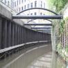
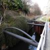
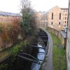
Lowered canal to pass under Queen Street at a lower level than originally constructed. Conrete walls are held apart by round beams at the top of the cutting.

 
Photos
 
External websites
There are no links to external websites from here.
Why not log in and add some (select "External websites" from the menu (sometimes this is under "Edit"))?
 
Nearest facilities

Mouseover for more information or show routes to facility

Nearest water point

In the direction of Ashton-under-Lyne Junction

Waterside Lock No 21E4 miles, 2 furlongs and 19 locks away
On this waterway in the direction of Ashton-under-Lyne Junction
Slaithwaite Winding Hole4 miles, 2¾ furlongs and 20 locks away
On this waterway in the direction of Ashton-under-Lyne Junction
Standedge Tunnel (eastern entrance)7 miles, 5¾ furlongs and 41 locks away
On this waterway in the direction of Ashton-under-Lyne Junction
Standedge Tunnel (western entrance)10 miles, 7½ furlongs and 41 locks away
On this waterway in the direction of Ashton-under-Lyne Junction
Wool Road Bridge No 7012 miles, 7½ furlongs and 50 locks away
On this waterway in the direction of Ashton-under-Lyne Junction
Grove Road Bridge No 9618 miles, 7½ furlongs and 65 locks away
On this waterway in the direction of Ashton-under-Lyne Junction

In the direction of Aspley Basin (Huddersfield)

Aspley Basin (Huddersfield)3½ furlongs and 1 lock away
On this waterway in the direction of Aspley Basin (Huddersfield)
Shepley Bridge Sanitary Station7 miles and 12 locks away
Travel to Aspley Basin (Huddersfield), then on the Huddersfield Broad Canal to Cooper Bridge Junction, then on the Calder and Hebble Navigation (Main Line) to Shepley Bridge Sanitary Station
Brighouse Basin6 miles, 1¾ furlongs and 14 locks away
Travel to Aspley Basin (Huddersfield), then on the Huddersfield Broad Canal to Cooper Bridge Junction, then on the Calder and Hebble Navigation (Main Line) to Brighouse Basin
Salterhebble Sanitary Station10 miles, 3¾ furlongs and 23 locks away
Travel to Aspley Basin (Huddersfield), then on the Huddersfield Broad Canal to Cooper Bridge Junction, then on the Calder and Hebble Navigation (Main Line) to Salterhebble Sanitary Station
Broad Cut Low Lock No 313 miles, 5 furlongs and 20 locks away
Travel to Aspley Basin (Huddersfield), then on the Huddersfield Broad Canal to Cooper Bridge Junction, then on the Calder and Hebble Navigation (Main Line) to Broad Cut Low Lock No 3
Salterhebble Junction10 miles, 4¼ furlongs and 24 locks away
Travel to Aspley Basin (Huddersfield), then on the Huddersfield Broad Canal to Cooper Bridge Junction, then on the Calder and Hebble Navigation (Main Line) to Salterhebble Junction
Sowerby Bridge Basin12 miles, 6 furlongs and 24 locks away
Travel to Aspley Basin (Huddersfield), then on the Huddersfield Broad Canal to Cooper Bridge Junction, then on the Calder and Hebble Navigation (Main Line) to Salterhebble Junction, then on the Calder and Hebble Navigation (Main Line) to Sowerby Bridge Basin
Ramsdens Bridge Sanitary Station19 miles, ¾ furlongs and 24 locks away
Travel to Aspley Basin (Huddersfield), then on the Huddersfield Broad Canal to Cooper Bridge Junction, then on the Calder and Hebble Navigation (Main Line) to Fall Ing Junction, then on the Aire and Calder Navigation (Wakefield Section) to Ramsdens Bridge Sanitary Station
Stanley Ferry Water Point19 miles, 1½ furlongs and 24 locks away
Travel to Aspley Basin (Huddersfield), then on the Huddersfield Broad Canal to Cooper Bridge Junction, then on the Calder and Hebble Navigation (Main Line) to Fall Ing Junction, then on the Aire and Calder Navigation (Wakefield Section) to Stanley Ferry Water Point
Hebden Bridge Services18 miles, 1½ furlongs and 31 locks away
Travel to Aspley Basin (Huddersfield), then on the Huddersfield Broad Canal to Cooper Bridge Junction, then on the Calder and Hebble Navigation (Main Line) to Salterhebble Junction, then on the Calder and Hebble Navigation (Main Line) to Sowerby Bridge Junction, then on the Rochdale Canal to Hebden Bridge Services

Nearest rubbish disposal

In the direction of Ashton-under-Lyne Junction

Pickle Lock No 22E4 miles, 3¼ furlongs and 20 locks away
On this waterway in the direction of Ashton-under-Lyne Junction
Wool Road Visitor Mooring12 miles, 7¾ furlongs and 50 locks away
On this waterway in the direction of Ashton-under-Lyne Junction

In the direction of Aspley Basin (Huddersfield)

Aspley Basin (Huddersfield)3½ furlongs and 1 lock away
On this waterway in the direction of Aspley Basin (Huddersfield)
Shepley Bridge Sanitary Station7 miles and 12 locks away
Travel to Aspley Basin (Huddersfield), then on the Huddersfield Broad Canal to Cooper Bridge Junction, then on the Calder and Hebble Navigation (Main Line) to Shepley Bridge Sanitary Station
Brighouse Lower Basin Visitor Moorings6 miles, 1½ furlongs and 13 locks away
Travel to Aspley Basin (Huddersfield), then on the Huddersfield Broad Canal to Cooper Bridge Junction, then on the Calder and Hebble Navigation (Main Line) to Brighouse Lower Basin Visitor Moorings
Horbury Basin Residential Moorings & Sanitary Station11 miles, 4½ furlongs and 19 locks away
Travel to Aspley Basin (Huddersfield), then on the Huddersfield Broad Canal to Cooper Bridge Junction, then on the Calder and Hebble Navigation (Main Line) to Horbury Basin Residential Moorings & Sanitary Station
Salterhebble Sanitary Station10 miles, 3¾ furlongs and 23 locks away
Travel to Aspley Basin (Huddersfield), then on the Huddersfield Broad Canal to Cooper Bridge Junction, then on the Calder and Hebble Navigation (Main Line) to Salterhebble Sanitary Station
Sowerby Bridge Basin12 miles, 6 furlongs and 24 locks away
Travel to Aspley Basin (Huddersfield), then on the Huddersfield Broad Canal to Cooper Bridge Junction, then on the Calder and Hebble Navigation (Main Line) to Salterhebble Junction, then on the Calder and Hebble Navigation (Main Line) to Sowerby Bridge Basin
Ramsdens Bridge Visitor Moorings19 miles, 1¼ furlongs and 24 locks away
Travel to Aspley Basin (Huddersfield), then on the Huddersfield Broad Canal to Cooper Bridge Junction, then on the Calder and Hebble Navigation (Main Line) to Fall Ing Junction, then on the Aire and Calder Navigation (Wakefield Section) to Ramsdens Bridge Visitor Moorings
Hebden Bridge Services18 miles, 1½ furlongs and 31 locks away
Travel to Aspley Basin (Huddersfield), then on the Huddersfield Broad Canal to Cooper Bridge Junction, then on the Calder and Hebble Navigation (Main Line) to Salterhebble Junction, then on the Calder and Hebble Navigation (Main Line) to Sowerby Bridge Junction, then on the Rochdale Canal to Hebden Bridge Services

Nearest chemical toilet disposal

In the direction of Ashton-under-Lyne Junction

Waterside Lock No 21E4 miles, 2 furlongs and 19 locks away
On this waterway in the direction of Ashton-under-Lyne Junction
Pickle Lock No 22E4 miles, 3¼ furlongs and 20 locks away
On this waterway in the direction of Ashton-under-Lyne Junction
Wool Road Bridge No 7012 miles, 7½ furlongs and 50 locks away
On this waterway in the direction of Ashton-under-Lyne Junction
Grove Road Bridge No 9618 miles, 7½ furlongs and 65 locks away
On this waterway in the direction of Ashton-under-Lyne Junction

In the direction of Aspley Basin (Huddersfield)

Aspley Basin (Huddersfield)3½ furlongs and 1 lock away
On this waterway in the direction of Aspley Basin (Huddersfield)
Shepley Bridge Sanitary Station7 miles and 12 locks away
Travel to Aspley Basin (Huddersfield), then on the Huddersfield Broad Canal to Cooper Bridge Junction, then on the Calder and Hebble Navigation (Main Line) to Shepley Bridge Sanitary Station
Brighouse Basin6 miles, 1¾ furlongs and 14 locks away
Travel to Aspley Basin (Huddersfield), then on the Huddersfield Broad Canal to Cooper Bridge Junction, then on the Calder and Hebble Navigation (Main Line) to Brighouse Basin
Savile Town Wharf and Basin (Dewsbury)10 miles, 3½ furlongs and 16 locks away
Travel to Aspley Basin (Huddersfield), then on the Huddersfield Broad Canal to Cooper Bridge Junction, then on the Calder and Hebble Navigation (Main Line) to Dewsbury Arm Junction, then on the Calder and Hebble Navigation (Dewsbury Old Cut) to Savile Town Wharf and Basin (Dewsbury)
Horbury Basin Residential Moorings & Sanitary Station11 miles, 4½ furlongs and 19 locks away
Travel to Aspley Basin (Huddersfield), then on the Huddersfield Broad Canal to Cooper Bridge Junction, then on the Calder and Hebble Navigation (Main Line) to Horbury Basin Residential Moorings & Sanitary Station
Salterhebble Sanitary Station10 miles, 3¾ furlongs and 23 locks away
Travel to Aspley Basin (Huddersfield), then on the Huddersfield Broad Canal to Cooper Bridge Junction, then on the Calder and Hebble Navigation (Main Line) to Salterhebble Sanitary Station
Sowerby Bridge Basin12 miles, 6 furlongs and 24 locks away
Travel to Aspley Basin (Huddersfield), then on the Huddersfield Broad Canal to Cooper Bridge Junction, then on the Calder and Hebble Navigation (Main Line) to Salterhebble Junction, then on the Calder and Hebble Navigation (Main Line) to Sowerby Bridge Basin
Ramsdens Bridge Sanitary Station19 miles, ¾ furlongs and 24 locks away
Travel to Aspley Basin (Huddersfield), then on the Huddersfield Broad Canal to Cooper Bridge Junction, then on the Calder and Hebble Navigation (Main Line) to Fall Ing Junction, then on the Aire and Calder Navigation (Wakefield Section) to Ramsdens Bridge Sanitary Station
Hebden Bridge Services18 miles, 1½ furlongs and 31 locks away
Travel to Aspley Basin (Huddersfield), then on the Huddersfield Broad Canal to Cooper Bridge Junction, then on the Calder and Hebble Navigation (Main Line) to Salterhebble Junction, then on the Calder and Hebble Navigation (Main Line) to Sowerby Bridge Junction, then on the Rochdale Canal to Hebden Bridge Services

Nearest place to turn

In the direction of Ashton-under-Lyne Junction

Isis Lock Winding Hole1 mile, 6 furlongs and 7 locks away
On this waterway in the direction of Ashton-under-Lyne Junction
Linthwaite Winding Hole3 miles, 2¼ furlongs and 15 locks away
On this waterway in the direction of Ashton-under-Lyne Junction
Slaithwaite Winding Hole4 miles, 2¾ furlongs and 20 locks away
On this waterway in the direction of Ashton-under-Lyne Junction

In the direction of Aspley Basin (Huddersfield)

University Arm2¾ furlongs and 1 lock away
On this waterway in the direction of Aspley Basin (Huddersfield)
Aspley Basin (Huddersfield)3½ furlongs and 1 lock away
On this waterway in the direction of Aspley Basin (Huddersfield)
Anchor Street Winding Hole1 mile, ½ furlongs and 1 lock away
Travel to Aspley Basin (Huddersfield), then on the Huddersfield Broad Canal to Anchor Street Winding Hole
New Road Winding Hole1 mile, 3¾ furlongs and 1 lock away
Travel to Aspley Basin (Huddersfield), then on the Huddersfield Broad Canal to New Road Winding Hole
Deighton Road Bridge Winding Hole2 miles, 5½ furlongs and 6 locks away
Travel to Aspley Basin (Huddersfield), then on the Huddersfield Broad Canal to Deighton Road Bridge Winding Hole
Cooper Bridge Junction3 miles, 7½ furlongs and 10 locks away
Travel to Aspley Basin (Huddersfield), then on the Huddersfield Broad Canal to Cooper Bridge Junction
Battye Weir Entrance4 miles, 4½ furlongs and 11 locks away
Travel to Aspley Basin (Huddersfield), then on the Huddersfield Broad Canal to Cooper Bridge Junction, then on the Calder and Hebble Navigation (Main Line) to Battye Weir Entrance
Shepley Bridge Marina7 miles, ¼ furlongs and 12 locks away
Travel to Aspley Basin (Huddersfield), then on the Huddersfield Broad Canal to Cooper Bridge Junction, then on the Calder and Hebble Navigation (Main Line) to Shepley Bridge Marina
Brighouse Basin6 miles, 1¾ furlongs and 14 locks away
Travel to Aspley Basin (Huddersfield), then on the Huddersfield Broad Canal to Cooper Bridge Junction, then on the Calder and Hebble Navigation (Main Line) to Brighouse Basin
Ganny Winding Hole6 miles, 7¼ furlongs and 15 locks away
Travel to Aspley Basin (Huddersfield), then on the Huddersfield Broad Canal to Cooper Bridge Junction, then on the Calder and Hebble Navigation (Main Line) to Ganny Winding Hole
Dewsbury Arm Junction9 miles, 3½ furlongs and 16 locks away
Travel to Aspley Basin (Huddersfield), then on the Huddersfield Broad Canal to Cooper Bridge Junction, then on the Calder and Hebble Navigation (Main Line) to Dewsbury Arm Junction
Savile Town Wharf and Basin (Dewsbury)10 miles, 3½ furlongs and 16 locks away
Travel to Aspley Basin (Huddersfield), then on the Huddersfield Broad Canal to Cooper Bridge Junction, then on the Calder and Hebble Navigation (Main Line) to Dewsbury Arm Junction, then on the Calder and Hebble Navigation (Dewsbury Old Cut) to Savile Town Wharf and Basin (Dewsbury)
Horbury Basin Residential Moorings & Sanitary Station11 miles, 4½ furlongs and 19 locks away
Travel to Aspley Basin (Huddersfield), then on the Huddersfield Broad Canal to Cooper Bridge Junction, then on the Calder and Hebble Navigation (Main Line) to Horbury Basin Residential Moorings & Sanitary Station
Salterhebble Wharf10 miles, 3¼ furlongs and 22 locks away
Travel to Aspley Basin (Huddersfield), then on the Huddersfield Broad Canal to Cooper Bridge Junction, then on the Calder and Hebble Navigation (Main Line) to Salterhebble Wharf
Salterhebble Bottom Basin Visitor Moorings10 miles, 3½ furlongs and 22 locks away
Travel to Aspley Basin (Huddersfield), then on the Huddersfield Broad Canal to Cooper Bridge Junction, then on the Calder and Hebble Navigation (Main Line) to Salterhebble Bottom Basin Visitor Moorings
Salterhebble Sanitary Station10 miles, 3¾ furlongs and 23 locks away
Travel to Aspley Basin (Huddersfield), then on the Huddersfield Broad Canal to Cooper Bridge Junction, then on the Calder and Hebble Navigation (Main Line) to Salterhebble Sanitary Station
Waller Bridge Winding Hole13 miles, 3¼ furlongs and 20 locks away
Travel to Aspley Basin (Huddersfield), then on the Huddersfield Broad Canal to Cooper Bridge Junction, then on the Calder and Hebble Navigation (Main Line) to Waller Bridge Winding Hole

Nearest self-operated pump-out

In the direction of Ashton-under-Lyne Junction

Slaithwaite Winding Hole4 miles, 2¾ furlongs and 20 locks away
On this waterway in the direction of Ashton-under-Lyne Junction
Wool Road Bridge No 7012 miles, 7½ furlongs and 50 locks away
On this waterway in the direction of Ashton-under-Lyne Junction

In the direction of Aspley Basin (Huddersfield)

Ramsdens Bridge Sanitary Station19 miles, ¾ furlongs and 24 locks away
Travel to Aspley Basin (Huddersfield), then on the Huddersfield Broad Canal to Cooper Bridge Junction, then on the Calder and Hebble Navigation (Main Line) to Fall Ing Junction, then on the Aire and Calder Navigation (Wakefield Section) to Ramsdens Bridge Sanitary Station
Hebden Bridge Services18 miles, 1½ furlongs and 31 locks away
Travel to Aspley Basin (Huddersfield), then on the Huddersfield Broad Canal to Cooper Bridge Junction, then on the Calder and Hebble Navigation (Main Line) to Salterhebble Junction, then on the Calder and Hebble Navigation (Main Line) to Sowerby Bridge Junction, then on the Rochdale Canal to Hebden Bridge Services

Nearest boatyard pump-out

Direction of TV transmitter (From Wolfbane Cybernetic)
 
 
Geograph
 
Wikipedia

There is no page on Wikipedia called “Queen Street Cutting”

Wikipedia pages that might relate to Queen Street Cutting
[Queen Street, London] thoroughfares of Queen Street and King Street (a northward continuation of Queen Street beyond Cheapside) were newly laid out, cutting across more ancient [Queen (band)] him becoming an official member, and cutting new material with him. In November 2014 Queen released a new album Queen Forever. The album is largely a compilation [Jill Schoelen] actress. She is best known for Chiller (1985), The Stepfather (1987), Cutting Class (1989), The Phantom of the Opera (1989), Popcorn (1991), Rich Girl [Parkdale station (Toronto)] the site. On the original station site, Sudbury Street has been extended north to Queen Street, cutting through the original lands. On the west side, the [The Bootleg Series Vol. 12: The Cutting Edge 1965–1966] The Bootleg Series Vol. 12: The Cutting Edge 1965–1966 is a compilation album by the American singer-songwriter Bob Dylan, released on Legacy Records [A258 road] away from the coast on 'Broad Street', where it crosses over the pedestrianised high street and becoming 'Queen Street'. It passes over the railway close [Ingrid of Sweden] (Ingrid Victoria Sofia Louisa Margareta; 28 March 1910 – 7 November 2000) was Queen of Denmark from 20 April 1947 to 14 January 1972 as the wife of King Frederik IX [Jay Sebring] Cemetery in Southfield, Michigan. Steve McQueen gave the eulogy. A feature-length documentary Jay Sebring....Cutting to the Truth was released in September [Alexander McQueen] Saint Martins (CSM). McQueen turned up at CSM with a pile of sample clothing and no appointment, seeking a job teaching pattern cutting. Hillson considered [Jane Curtin] Conehead, in the 1993 film Coneheads. She is sometimes referred to as the "Queen of Deadpan". The Philadelphia Inquirer once called her a "refreshing drop
 
Google