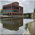
London Road Railway Bridge (dismantled)
is a minor waterways place
on the River Trent (Nottingham Canal) between
Meadow Lane Junction (Junction of Nottingham Canal with River Trent) (3 furlongs
and 1 lock
to the southeast) and
Carrington Street Bridge (Nottingham) (1½ furlongs
to the west).
The nearest place in the direction of Meadow Lane Junction is Station Street Bridge;
a few yards
away.
The nearest place in the direction of Carrington Street Bridge is Poplar Arms Corner (Very sharp bend. A short arm used to head east from here.);
a few yards
away.
Mooring here is unrated.
There is a bridge here which takes a railway over the canal.
| Meadow Lane Bridge | 2¼ furlongs | |
| Cattle Market Road Bridge | 1¼ furlongs | |
| Queen's Road Bridge | ½ furlongs | |
| LMS Railway Bridge | ¼ furlongs | |
| Station Street Bridge | a few yards | |
| London Road Railway Bridge (dismantled) | ||
| Poplar Arms Corner | a few yards | |
| London Road Bridge | ¼ furlongs | |
| Boots Pipe Bridge | ¾ furlongs | |
| Trent Street Bridge | 1 furlong | |
| Nottingham Tram Railway Bridge | 1 furlong | |
Amenities nearby at Poplar Arms Corner
Amenities in Nottingham
Amenities at other places in Nottingham
There are no links to external websites from here.
Why not log in and add some (select "External websites" from the menu (sometimes this is under "Edit"))?
Mouseover for more information or show routes to facility
Nearest water point
In the direction of Lenton Chain
Beeston Lock No 5 — 5 miles, 4¼ furlongs and 1 lock away
Travel to Lenton Chain, then on the River Trent (Beeston Canal) to Beeston Lock No 5
Cranfleet Lock No 3 — 9 miles, 6¾ furlongs and 2 locks away
Travel to Lenton Chain, then on the River Trent (Beeston Canal) to Beeston Lock No 5, then on the River Trent (Western End) to Cranfleet Lock No 3
Former BW Trent Lock Waterway Office — 10 miles, 5¼ furlongs and 5 locks away
Travel to Lenton Chain, then on the River Trent (Beeston Canal) to Beeston Lock No 5, then on the River Trent (Western End) to Trent Junction, then on the Grand Union Canal (Erewash Canal) to Former BW Trent Lock Waterway Office
Sawley Locks No 2 — 11 miles, 3¼ furlongs and 4 locks away
Travel to Lenton Chain, then on the River Trent (Beeston Canal) to Beeston Lock No 5, then on the River Trent (Western End) to Sawley Locks No 2
Shardlow — 13 miles, 5 furlongs and 7 locks away
Travel to Lenton Chain, then on the River Trent (Beeston Canal) to Beeston Lock No 5, then on the River Trent (Western End) to Derwent Mouth, then on the Trent and Mersey Canal (Main Line - Derwent Mouth to Burton) to Shardlow
Weston Lock No 4 — 16 miles, 4½ furlongs and 9 locks away
Travel to Lenton Chain, then on the River Trent (Beeston Canal) to Beeston Lock No 5, then on the River Trent (Western End) to Derwent Mouth, then on the Trent and Mersey Canal (Main Line - Derwent Mouth to Burton) to Weston Lock No 4
Bishop Meadow Lock No 54 — 18 miles, 5¼ furlongs and 9 locks away
Travel to Lenton Chain, then on the River Trent (Beeston Canal) to Beeston Lock No 5, then on the River Trent (Western End) to Trent Junction, then on the Grand Union Canal (Leicester Section - River Soar Navigation) to Bishop Meadow Lock No 54
Swarkestone Lock No 5 — 19 miles, 3¾ furlongs and 10 locks away
Travel to Lenton Chain, then on the River Trent (Beeston Canal) to Beeston Lock No 5, then on the River Trent (Western End) to Derwent Mouth, then on the Trent and Mersey Canal (Main Line - Derwent Mouth to Burton) to Swarkestone Lock No 5
Loughborough Basin — 19 miles, 6 furlongs and 11 locks away
Travel to Lenton Chain, then on the River Trent (Beeston Canal) to Beeston Lock No 5, then on the River Trent (Western End) to Trent Junction, then on the Grand Union Canal (Leicester Section - River Soar Navigation) to Loughborough Branch Junction, then on the Grand Union Canal (Leicester Section - Loughborough Branch) to Loughborough Basin
In the direction of Meadow Lane Junction
Holme Lock No 5 — 2 miles, 6¼ furlongs and 1 lock away
Travel to Meadow Lane Junction, then on the River Trent (non-tidal section) to Holme Lock No 5
Stoke Lock No 6 — 5 miles, 6½ furlongs and 2 locks away
Travel to Meadow Lane Junction, then on the River Trent (non-tidal section) to Stoke Lock No 6
Gunthorpe Lock No 7 — 10 miles, 4½ furlongs and 3 locks away
Travel to Meadow Lane Junction, then on the River Trent (non-tidal section) to Gunthorpe Lock No 7
Hazelford Lock No 8 — 15 miles, 2½ furlongs and 4 locks away
Travel to Meadow Lane Junction, then on the River Trent (non-tidal section) to Hazelford Lock No 8Nearest rubbish disposal
In the direction of Lenton Chain
Beeston Lock No 5 — 5 miles, 4¼ furlongs and 1 lock away
Travel to Lenton Chain, then on the River Trent (Beeston Canal) to Beeston Lock No 5
Cranfleet Lock No 3 — 9 miles, 6¾ furlongs and 2 locks away
Travel to Lenton Chain, then on the River Trent (Beeston Canal) to Beeston Lock No 5, then on the River Trent (Western End) to Cranfleet Lock No 3
Former BW Trent Lock Waterway Office — 10 miles, 5¼ furlongs and 5 locks away
Travel to Lenton Chain, then on the River Trent (Beeston Canal) to Beeston Lock No 5, then on the River Trent (Western End) to Trent Junction, then on the Grand Union Canal (Erewash Canal) to Former BW Trent Lock Waterway Office
Sawley Locks No 2 — 11 miles, 3¼ furlongs and 4 locks away
Travel to Lenton Chain, then on the River Trent (Beeston Canal) to Beeston Lock No 5, then on the River Trent (Western End) to Sawley Locks No 2
Swarkestone Lock No 5 — 19 miles, 3¾ furlongs and 10 locks away
Travel to Lenton Chain, then on the River Trent (Beeston Canal) to Beeston Lock No 5, then on the River Trent (Western End) to Derwent Mouth, then on the Trent and Mersey Canal (Main Line - Derwent Mouth to Burton) to Swarkestone Lock No 5
Loughborough Basin — 19 miles, 6 furlongs and 11 locks away
Travel to Lenton Chain, then on the River Trent (Beeston Canal) to Beeston Lock No 5, then on the River Trent (Western End) to Trent Junction, then on the Grand Union Canal (Leicester Section - River Soar Navigation) to Loughborough Branch Junction, then on the Grand Union Canal (Leicester Section - Loughborough Branch) to Loughborough Basin
In the direction of Meadow Lane Junction
Holme Lock No 5 — 2 miles, 6¼ furlongs and 1 lock away
Travel to Meadow Lane Junction, then on the River Trent (non-tidal section) to Holme Lock No 5
Stoke Lock No 6 — 5 miles, 6½ furlongs and 2 locks away
Travel to Meadow Lane Junction, then on the River Trent (non-tidal section) to Stoke Lock No 6
Gunthorpe Lock No 7 — 10 miles, 4½ furlongs and 3 locks away
Travel to Meadow Lane Junction, then on the River Trent (non-tidal section) to Gunthorpe Lock No 7
Hazelford Lock No 8 — 15 miles, 2½ furlongs and 4 locks away
Travel to Meadow Lane Junction, then on the River Trent (non-tidal section) to Hazelford Lock No 8Nearest chemical toilet disposal
In the direction of Lenton Chain
Beeston Lock No 5 — 5 miles, 4¼ furlongs and 1 lock away
Travel to Lenton Chain, then on the River Trent (Beeston Canal) to Beeston Lock No 5
Former BW Trent Lock Waterway Office — 10 miles, 5¼ furlongs and 5 locks away
Travel to Lenton Chain, then on the River Trent (Beeston Canal) to Beeston Lock No 5, then on the River Trent (Western End) to Trent Junction, then on the Grand Union Canal (Erewash Canal) to Former BW Trent Lock Waterway Office
Sawley Locks No 2 — 11 miles, 3¼ furlongs and 4 locks away
Travel to Lenton Chain, then on the River Trent (Beeston Canal) to Beeston Lock No 5, then on the River Trent (Western End) to Sawley Locks No 2
Sawley Cut Wharf — 11 miles, 4¾ furlongs and 5 locks away
Travel to Lenton Chain, then on the River Trent (Beeston Canal) to Beeston Lock No 5, then on the River Trent (Western End) to Sawley Cut Wharf
In the direction of Meadow Lane Junction
Meadow Lane Lock No 7 — 2¾ furlongs away
On this waterway in the direction of Meadow Lane Junction
Holme Lock No 5 — 2 miles, 6¼ furlongs and 1 lock away
Travel to Meadow Lane Junction, then on the River Trent (non-tidal section) to Holme Lock No 5
Stoke Lock No 6 — 5 miles, 6½ furlongs and 2 locks away
Travel to Meadow Lane Junction, then on the River Trent (non-tidal section) to Stoke Lock No 6
Gunthorpe Lock No 7 — 10 miles, 4½ furlongs and 3 locks away
Travel to Meadow Lane Junction, then on the River Trent (non-tidal section) to Gunthorpe Lock No 7Nearest place to turn
In the direction of Lenton Chain
Poplar Arms Corner — a few yards away
On this waterway in the direction of Lenton Chain
Canal Museum Wharf — 1¾ furlongs away
On this waterway in the direction of Lenton Chain
Redfield Road Bridge Winding Hole — 2 miles, 1¾ furlongs and 1 lock away
Travel to Lenton Chain, then on the River Trent (Beeston Canal) to Redfield Road Bridge Winding Hole
Rylands Bridge Winding Hole — 4 miles, 2 furlongs and 1 lock away
Travel to Lenton Chain, then on the River Trent (Beeston Canal) to Rylands Bridge Winding Hole
Cranfleet Lock Weir Exit — 9 miles, 6 furlongs and 2 locks away
Travel to Lenton Chain, then on the River Trent (Beeston Canal) to Beeston Lock No 5, then on the River Trent (Western End) to Cranfleet Lock Weir Exit
Soar Mouth — 10 miles, 5¾ furlongs and 4 locks away
Travel to Lenton Chain, then on the River Trent (Beeston Canal) to Beeston Lock No 5, then on the River Trent (Western End) to Trent Junction, then on the Grand Union Canal (Leicester Section - River Soar Navigation) to Soar Mouth
Redhill Lock Junction — 11 miles, ¼ furlongs and 4 locks away
Travel to Lenton Chain, then on the River Trent (Beeston Canal) to Beeston Lock No 5, then on the River Trent (Western End) to Trent Junction, then on the Grand Union Canal (Leicester Section - River Soar Navigation) to Redhill Lock Junction
Sawley Lock No 2 Weir Exit — 11 miles, 2½ furlongs and 4 locks away
Travel to Lenton Chain, then on the River Trent (Beeston Canal) to Beeston Lock No 5, then on the River Trent (Western End) to Sawley Lock No 2 Weir Exit
Former BW Trent Lock Waterway Office — 10 miles, 5¼ furlongs and 5 locks away
Travel to Lenton Chain, then on the River Trent (Beeston Canal) to Beeston Lock No 5, then on the River Trent (Western End) to Trent Junction, then on the Grand Union Canal (Erewash Canal) to Former BW Trent Lock Waterway Office
Sheet Stores Basin — 11 miles, 2¼ furlongs and 5 locks away
Travel to Lenton Chain, then on the River Trent (Beeston Canal) to Beeston Lock No 5, then on the River Trent (Western End) to Trent Junction, then on the Grand Union Canal (Erewash Canal) to Sheet Stores Basin
Redhill Marine Ltd — 11 miles, 4½ furlongs and 5 locks away
Travel to Lenton Chain, then on the River Trent (Beeston Canal) to Beeston Lock No 5, then on the River Trent (Western End) to Trent Junction, then on the Grand Union Canal (Leicester Section - River Soar Navigation) to Redhill Marine Ltd
Ratcliffe Lock Junction — 11 miles, 7 furlongs and 5 locks away
Travel to Lenton Chain, then on the River Trent (Beeston Canal) to Beeston Lock No 5, then on the River Trent (Western End) to Trent Junction, then on the Grand Union Canal (Leicester Section - River Soar Navigation) to Ratcliffe Lock Junction
Sawley Flood Lock Weir Entrance — 12 miles, ¼ furlongs and 6 locks away
Travel to Lenton Chain, then on the River Trent (Beeston Canal) to Beeston Lock No 5, then on the River Trent (Western End) to Sawley Flood Lock Weir Entrance
Ratcliffe Weir — 12 miles, 2 furlongs and 6 locks away
Travel to Lenton Chain, then on the River Trent (Beeston Canal) to Beeston Lock No 5, then on the River Trent (Western End) to Trent Junction, then on the Grand Union Canal (Leicester Section - River Soar Navigation) to Ratcliffe Weir
Long Eaton Winding Hole — 12 miles, 4 furlongs and 6 locks away
Travel to Lenton Chain, then on the River Trent (Beeston Canal) to Beeston Lock No 5, then on the River Trent (Western End) to Trent Junction, then on the Grand Union Canal (Erewash Canal) to Long Eaton Winding Hole
Derwent Mouth — 12 miles, 4¼ furlongs and 6 locks away
Travel to Lenton Chain, then on the River Trent (Beeston Canal) to Beeston Lock No 5, then on the River Trent (Western End) to Derwent Mouth
In the direction of Meadow Lane Junction
Holme Lock Weir Entrance — 2 miles, 4¾ furlongs and 1 lock away
Travel to Meadow Lane Junction, then on the River Trent (non-tidal section) to Holme Lock Weir Entrance
Holme Lock Weir Exit — 2 miles, 7½ furlongs and 2 locks away
Travel to Meadow Lane Junction, then on the River Trent (non-tidal section) to Holme Lock Weir Exit
Hazelford Lock East Weir Entrance — 14 miles, 5¼ furlongs and 4 locks away
Travel to Meadow Lane Junction, then on the River Trent (non-tidal section) to Hazelford Lock East Weir Entrance
Hazelford Ferry — 14 miles, 5¾ furlongs and 4 locks away
Travel to Meadow Lane Junction, then on the River Trent (non-tidal section) to Hazelford FerryNo information
CanalPlan has no information on any of the following facilities within range:self-operated pump-out
boatyard pump-out
Direction of TV transmitter (From Wolfbane Cybernetic)
There is no page on Wikipedia called “London Road Railway Bridge”
Wikipedia pages that might relate to London Road Railway Bridge
[London Bridge]
Bridge opened in 1729, London Bridge was the only road-crossing of the Thames downstream of Kingston upon Thames. London Bridge has been depicted in its
[London Bridge station]
London Bridge is a central London railway terminus and connected London Underground station in Southwark, south-east London. It occupies a large area
[Blackfriars station]
the only one in London to do so, along the length of Blackfriars Railway Bridge, a short distance downstream from Blackfriars Bridge. There are two station
[Lea Bridge Road]
road are the Lea Valley Park, Lea Bridge railway station and the Baker's Arms area. Formerly the Lea Bridge Stadium was located along Lea Bridge Road
[Charing Cross railway station]
Charing Cross railway station (also known as London Charing Cross) is a central London railway terminus between the Strand and Hungerford Bridge in the City
[Blackfriars Bridge]
Blackfriars Bridge is a road and foot traffic bridge over the River Thames in London, between Waterloo Bridge and Blackfriars Railway Bridge, carrying the
[London Necropolis railway station]
London Necropolis railway station was the Waterloo, London terminus of the London Necropolis Railway. The London Necropolis Railway was opened in 1854
[Lea Bridge railway station]
of Lea Bridge Road as it crosses the tracks. The station was opened on 15 September 1840 by the Northern and Eastern Railway as Lea Bridge Road and is
[List of bridges in London]
List of bridges in London lists the major bridges within Greater London or within the influence of London. Most of these are river crossings, and the
[Tower Bridge]
Tower Bridge is a combined bascule and suspension bridge in London, built between 1886 and 1894. The bridge crosses the River Thames close to the Tower
Results of Google Search
The River Thames is the second-longest river in the United Kingdom. It is crossed by over 200 ... Several central London road bridges were built in the 19th century, most ... Railway Bridge in central London, and the spectacular railway bridges by ... "Emergency Thames Bridge: Millbank site, structure is dismantled". City of ...
May 31, 2009 ... The bridge carries the old Midland Railway main line over London Road, formerly the A6 but now the A1081.
This is a list of bridge failures. This transport-related list is incomplete; you can help by ... Bridge reconstructed, dismantled in 1843, [2] ... Norwood Junction Rail Bridge, London, England, 1 May 1891, Cast iron girder fails under ... Collapsed underneath train due to heavy rainfall and debris build-up from a road bridge wiped ...
Nov 5, 2019 ... The replacement of Bromham Road Bridge is growing nearer, as the old bridge was ... Network Rail has shared time-lapse footage of the demolition in ... Bromham Road bridge is the last of these bridges to be demolished, marking a ... to Market Harborough and Bedford to London St Pancras meaning your ...
Several bridges named London Bridge have spanned the River Thames between the City of ... The first London Bridge was built by the Romans as part of their road-building ... all the properties on the bridge so that they could be demolished and the bridge improved. ... London Bridge station is also served by National Rail.
Apr 4, 2011 ... The two historic London, Chatham & Dover Railway crests at the southern end of ... The original Blackfriars Railway Bridge was dismantled in 1985 but the ... The Thames Path will be diverted to run underneath the southern ...
Title: Dismantling of Heeley Railway Bridge, London Road, c.1982. Location: Sheffield_Heeley. Date Period: 1980-1999. Photographer: Douglas Axe. Copyright ...
Sep 15, 2015 ... In fact, an English Heritage plaque on the railway bridge a little further down Grove Road commemorates the first one to strike London. The blitz ...
Mar 8, 2013 ... Mayor of London Boris Johnson has urged the developers of the Ludgate House and ... Boris calls for new open space on Blackfriars rail bridge pillars ... and redevelopment of Ludgate House on Blackfriars Road and Sampson House on Hopton Street. ... The bridge they carried was dismantled in 1984.


![The Island Quarter: developments by the canal. This new building has gone up on derelict land next to the Nottingham Canal. It will house two restaurants, one of which will be Cleaver & Wake (see https://www.cleaverandwake.com ). The steps to and from the towpath are being restored and a blue-brick retaining wall built by the Great Northern Railway has been reworked in Derbyshire stone, to match the canal bridge from which this picture was taken.For more about The Island Quarter, try https://www.theislandquarter.com/masterplan and for an idea of what this area was like until quite recently, see Alan Murray-Rust's [[[678686]]] and my [[[1890830]]] and [[[1891178]]]. by John Sutton – 07 September 2022](https://s3.geograph.org.uk/geophotos/07/27/77/7277783_26d90541_120x120.jpg)


![Across the canal. The blue-brick retaining wall on the right once supported the huge girder bridge which carried the Nottingham Victoria to Grantham line across London Road and the Nottingham Canal. London Road High Level was to the right. The canal once had a branch to the right, serving a gasworks and other industries. It was overlooked by the Boots the Chemists buildings shown in Nigel Thompson's [[[3211374]]]. In the background, the white crane is on the site of an addition to the Biocity complex, by John Sutton – 16 May 2016](https://s1.geograph.org.uk/geophotos/04/95/77/4957789_fa3dc2ec_120x120.jpg)


![The Island Quarter: Phase 1. Derelict land formerly occupied by factories and a long-gone railway is being developed as Nottingham's Island Quarter. For more about it, try https://www.theislandquarter.com/masterplan .This part of the development occupies the site of the former London Road High Level railway station (see Nigel Thompson's [[[3211374]]]). The derelict goods warehouses of the Low Level station, also built by the Great Northern Railway, are in the distance on the right. by John Sutton – 07 September 2022](https://s1.geograph.org.uk/geophotos/07/27/77/7277777_b2d47bb6_120x120.jpg)
![The former Great Northern Railway Station. London Road Station, the original terminus of GNR trains from Grantham and Derby and GN&LNWJt Line services from Northampton, was designed in French chateau style by the Nottingham architect T C Hine. Passenger services - only the Northamptons remained after 1900 when Grantham trains began to use the then new Victoria - ceased in 1944, but the Low Level station (as it was known to distinguish it from the long-gone London Road High Level, offstage left, on the GNR line to Nottingham Victoria, now completely obliterated) was used for many years as a parcels depot. It is now a health club. Part of the burned-out shell of the goods warehouse shows on the extreme left of the picture.For a fine broadside view, see Stephen Richards' [[[4117784]]]. by John Sutton – 21 August 2014](https://s1.geograph.org.uk/geophotos/04/32/90/4329045_5e8dcc2b_120x120.jpg)