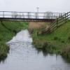
Arram Beck
Tributary of the Hull (un-navigable)
Pulfin, Beck Lane, Aike YO25 9BG, United Kingdom
Address is taken from a point 252 yards away.

Arram Beck
is a minor waterways place
on the River Hull (Main Line) between
Aike Beck Junction (Aike Beck used to join here) (1 mile and 3¾ furlongs
to the northeast) and
Grovehill Junction (Junction with Beverley Beck - a tributary of the Hull) (3 miles and 2¾ furlongs
to the south).
The nearest place in the direction of Aike Beck Junction is Leven Canal Junction (Leven Canal (closed));
1 mile and ¼ furlongs
away.
The nearest place in the direction of Grovehill Junction is New Hull Bridge;
1 mile and 5 furlongs
away.
Mooring here is unrated.
Wilfholme Beck | 2 miles, 6¾ furlongs | |
Wilfholme Landing | 2 miles, 5¾ furlongs | |
Linley Hill | 2 miles, 1½ furlongs | |
Aike Beck Junction | 1 mile, 3¾ furlongs | |
Leven Canal Junction | 1 mile, ¼ furlongs | |
Arram Beck | ||
New Hull Bridge | 1 mile, 5 furlongs | |
Hull Bridge | 1 mile, 5½ furlongs | |
Beverley Boat Hire | 1 mile, 5¾ furlongs | |
Weel Bridge | 3 miles, ¼ furlongs | |
Grovehill Junction | 3 miles, 2¾ furlongs |
There are no links to external websites from here.
Why not log in and add some (select "External websites" from the menu (sometimes this is under "Edit"))?
Mouseover for more information or show routes to facility
Nearest water point
In the direction of River Hull - Humber Junction
Beverley Beck Visitor Moorings — 4 miles, ¾ furlongs and 1 lock away
Travel to Grovehill Junction, then on the River Hull (Beverley Beck) to Beverley Beck Visitor MooringsNearest place to turn
In the direction of River Hull - Humber Junction
Beverley Beck Wharves — 4 miles, ¼ furlongs and 1 lock away
Travel to Grovehill Junction, then on the River Hull (Beverley Beck) to Beverley Beck Wharves
Tower Street Basin — 13 miles, 1½ furlongs away
On this waterway in the direction of River Hull - Humber Junction
In the direction of Struncheon Hill Locks Nos 6 and 7
Aike Beck Junction — 1 mile, 3¾ furlongs away
On this waterway in the direction of Struncheon Hill Locks Nos 6 and 7No information
CanalPlan has no information on any of the following facilities within range:rubbish disposal
chemical toilet disposal
self-operated pump-out
boatyard pump-out
Direction of TV transmitter (From Wolfbane Cybernetic)
Wikipedia has a page about Arram Beck
Arram Beck is a small stream in the East Riding of Yorkshire, England, running through high embankments and flowing eastwards from the village of Arram to join the River Hull. Depths are variable due to the tidal nature of the Hull. It provides habitat for a variety of fish species (including perch, dace, roach) and chub have also been stocked here too.
Other Wikipedia pages that might relate to Arram Beck
[River Hull]
former junction with Aike Beck, once navigable to Lockington Landing, but the stream was subsequently re-routed to join the Arram Beck. The Leven Canal used
[Aike Beck]
water supply came from Bryan Mills Beck and Scorborough Beck, but in 1988, these were diverted to feed into Arram Beck, and most of the channel was filled
[Arram]
Arram is a small (population 200) farming village in the East Riding of Yorkshire, England. It is situated approximately 3 miles (5 km) north of the market
[River Wharfe]
'liquid'). The river source is the confluence of Oughtershaw Beck and Green Field Beck in Langstrothdale near Beckermonds. It flows east and south-east
[River Ouse, Yorkshire]
formed at the confluence of the River Ure and the much smaller Ouse Gill Beck at Cuddy Shaw Reach near Linton-on-Ouse, about six miles downstream of the
[Beverley and Barmston Drain]
drain under Aike Beck before it was re-routed into Arram Beck and filled in. Near Arram, another tunnel carries it under Arram Beck, and it follows a
[Beverley Beck]
were fitted in 1953. Situated on the River Hull Next place upstream = Arram Beck United Kingdom portal Transport portal Canals of the United Kingdom History
[Humber]
Ribble Ryburn Spen Tyersal Beck Wharfe Worth Wyke Beck East Riding of Yorkshire Aike Beck Aire Arram Beck Derwent Driffield Beck Foulness Gypsey Race Hedon
[River Tees]
meander. Neither meander is visible today, except for the flow of Stainsby Beck into a waterway which is marked on maps first as "The Fleet" and then "Old
Results of Google Search
Arram Beck - WikipediaArram Beck is a small stream in the East Riding of Yorkshire, England, running through high embankments and flowing eastwards from the village of Arram to ...
Aug 17, 2007 ... Arram Beck flows over the Barmston Drain (not shown, behind the photographer) and joins the river Hull.
Arram Beck · River Hull. Aike Beck or the Lockington Navigation was a stream in the East Riding of Yorkshire, England, ...
Arram_Beck_-_geograph.org.uk_-_470029.jpg #x200e;(640 × 454 pixels, file size: 85 KB , MIME type: image/jpeg). File information. Structured data ...
river in East Yorkshire, United Kingdom. In more languages. Spanish. No label defined. No description defined. Traditional Chinese. No label defined.
Arram_Beck_and_the_River_Hull._-_geograph.org.uk_-_527696.jpg #x200e;(640 × 480 pixels, file size: 97 KB, MIME type: image/jpeg). File information. Structured ...
Jun 26, 2017 ... S254 - River Hull from Arram Beck to Humber (PDF, 3.23MB) · S255 - Sands/ Keyingham/Roos Drain from Source to Humber (PDF, 2.57MB).
Arram_Beck_meets_the_River_Hull_-_geograph.org.uk_-_1194184.jpg #x200e;(640 × 426 pixels, file size: 202 KB, MIME type: image/jpeg). File information.
With few options left, the Commissioners built a steam pumping station at Arram Beck in 1868. The school is in the south of the West Bank, his family is in Arram, ...
English: Arram is a small (population 200) farming village in the East Riding of Yorkshire, ... Arram Beck - geograph.org.uk - 470029.jpg 640 × 454; 85 KB. Arram ...