

Railway Bridge No 97A
Waterways Avenue, Trafford M15 4QZ, United Kingdom
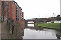
Railway Bridge No 97A carries a footpath over the Bridgewater Canal (Main Line) just past the junction with The Neath and Tennant Canal.
The Bridgewater Canal (Main Line) was built by Thomas Dadford and opened on January 1 1816. The canal joined the sea near Rotherham. "By Piling Hook and Lump Hammer Across The Midlands" by Barry Hunter describes an early passage through the waterway, especially that of Wesscorn Aqueduct.

Railway Bridge No 97A
is a minor waterways place
on the Bridgewater Canal (Main Line) between
Hulme Locks Branch - Bridgewater Canal Junction (Branch closed) (2¼ furlongs
to the northeast) and
Pomona Lock Branch Junction (Junction of Bridgewater Canal and Branch to Manchester Ship Canal) (3½ furlongs
to the southwest).
The nearest place in the direction of Hulme Locks Branch - Bridgewater Canal Junction is Railway Bridge No 98;
¼ furlongs
away.
The nearest place in the direction of Pomona Lock Branch Junction is Site of Hulme Hall Dry Dock;
¼ furlongs
away.
Mooring here is unrated.
There is a bridge here which takes a railway over the canal.
| Hulme Hall Arm | 1¼ furlongs | |
| Hulme Hall Road Winding Hole | 1¼ furlongs | |
| Hulme Hall Road Bridge No 99 | ¾ furlongs | |
| Former loading arm for Albert Mills | ½ furlongs | |
| Railway Bridge No 98 | ¼ furlongs | |
| Railway Bridge No 97A | ||
| Site of Hulme Hall Dry Dock | ¼ furlongs | |
| Cornbrook Road Bridge No 97 | 1½ furlongs | |
| Pomona Lock Branch Junction | 3½ furlongs | |
| Metrolink or Light Railway Bridge No 96 | 3½ furlongs | |
| Throstles Nest Bridge No 95B | 6¾ furlongs | |
There are no links to external websites from here.
Why not log in and add some (select "External websites" from the menu (sometimes this is under "Edit"))?
Why not log in and add some (select "External websites" from the menu (sometimes this is under "Edit"))?
Mouseover for more information or show routes to facility
Nearest water point
In the direction of Grocer's Wharf
Potato Wharf Arm & The New Basin — 3½ furlongs away
On this waterway in the direction of Grocer's Wharf
Staffordshire, Kenworthy and other Arms — 4¼ furlongs away
On this waterway in the direction of Grocer's Wharf
New Islington Marina — 2 miles, 2¼ furlongs and 11 locks away
Travel to Castlefield Junction, then on the Rochdale Canal to New Islington Marina Entrance, then on the Rochdale Canal (Main Line) to Cotton Field Wharf Marina, then on the Rochdale Canal (New Islington Marina Arm) to New Islington Marina
Fairfield Junction — 5 miles, 4½ furlongs and 27 locks away
Travel to Castlefield Junction, then on the Rochdale Canal to Ducie Street Junction, then on the Ashton Canal (Main Line) to Fairfield Junction
Grove Road Bridge No 96 — 13 miles, ¾ furlongs and 35 locks away
Travel to Castlefield Junction, then on the Rochdale Canal to Ducie Street Junction, then on the Ashton Canal (Main Line) to Ashton-under-Lyne Junction, then on the Huddersfield Narrow Canal to Grove Road Bridge No 96
Marple Services — 16 miles, 2 furlongs and 43 locks away
Travel to Castlefield Junction, then on the Rochdale Canal to Ducie Street Junction, then on the Ashton Canal (Main Line) to Dukinfield Junction, then on the Peak Forest Canal (Lower) to Marple Junction, then on the Macclesfield Canal to Marple Services
Braidbar Boats — 19 miles, 7½ furlongs and 43 locks away
Travel to Castlefield Junction, then on the Rochdale Canal to Ducie Street Junction, then on the Ashton Canal (Main Line) to Dukinfield Junction, then on the Peak Forest Canal (Lower) to Marple Junction, then on the Macclesfield Canal to Braidbar Boats
Littleborough Sanitary Station — 17 miles, 3¼ furlongs and 46 locks away
Travel to Castlefield Junction, then on the Rochdale Canal to Littleborough Sanitary Station
Wool Road Bridge No 70 — 19 miles, ¾ furlongs and 50 locks away
Travel to Castlefield Junction, then on the Rochdale Canal to Ducie Street Junction, then on the Ashton Canal (Main Line) to Ashton-under-Lyne Junction, then on the Huddersfield Narrow Canal to Wool Road Bridge No 70
In the direction of Waterloo Bridge (Runcorn)
Stretford Marina — 2 miles, 3¾ furlongs away
On this waterway in the direction of Waterloo Bridge (Runcorn)
Watch House Cruising Club — 3 miles, 4 furlongs away
On this waterway in the direction of Waterloo Bridge (Runcorn)
Worsley Visitor Moorings — 6 miles, 5¾ furlongs away
Travel to Stretford - Waters Meeting, then on the Bridgewater Canal (Stretford and Leigh Branch) to Worsley Visitor Moorings
Bridgewater Marina — 8 miles, 1¾ furlongs away
Travel to Stretford - Waters Meeting, then on the Bridgewater Canal (Stretford and Leigh Branch) to Bridgewater Marina
Ye Olde Number 3 Transit Moorings — 10 miles, 3 furlongs away
On this waterway in the direction of Waterloo Bridge (Runcorn)
Plank Lane Visitor Moorings — 14 miles, 6¼ furlongs away
Travel to Stretford - Waters Meeting, then on the Bridgewater Canal (Stretford and Leigh Branch) to Leigh Bridge No 11, then on the Leeds and Liverpool Canal (Leigh Branch) to Plank Lane Visitor MooringsNearest rubbish disposal
In the direction of Grocer's Wharf
Marple Bottom Lock Bridge Winding Hole — 15 miles, ¾ furlongs and 27 locks away
Travel to Castlefield Junction, then on the Rochdale Canal to Ducie Street Junction, then on the Ashton Canal (Main Line) to Dukinfield Junction, then on the Peak Forest Canal (Lower) to Marple Bottom Lock Bridge Winding Hole
Marple Services — 16 miles, 2 furlongs and 43 locks away
Travel to Castlefield Junction, then on the Rochdale Canal to Ducie Street Junction, then on the Ashton Canal (Main Line) to Dukinfield Junction, then on the Peak Forest Canal (Lower) to Marple Junction, then on the Macclesfield Canal to Marple Services
Braidbar Boats — 19 miles, 7½ furlongs and 43 locks away
Travel to Castlefield Junction, then on the Rochdale Canal to Ducie Street Junction, then on the Ashton Canal (Main Line) to Dukinfield Junction, then on the Peak Forest Canal (Lower) to Marple Junction, then on the Macclesfield Canal to Braidbar Boats
Littleborough Sanitary Station — 17 miles, 3¼ furlongs and 46 locks away
Travel to Castlefield Junction, then on the Rochdale Canal to Littleborough Sanitary Station
Wool Road Visitor Mooring — 19 miles, ½ furlongs and 50 locks away
Travel to Castlefield Junction, then on the Rochdale Canal to Ducie Street Junction, then on the Ashton Canal (Main Line) to Ashton-under-Lyne Junction, then on the Huddersfield Narrow Canal to Wool Road Visitor Mooring
In the direction of Waterloo Bridge (Runcorn)
Plank Lane Pump Out — 14 miles, 6¾ furlongs away
Travel to Stretford - Waters Meeting, then on the Bridgewater Canal (Stretford and Leigh Branch) to Leigh Bridge No 11, then on the Leeds and Liverpool Canal (Leigh Branch) to Plank Lane Pump OutNearest chemical toilet disposal
In the direction of Grocer's Wharf
Fairfield Junction — 5 miles, 4½ furlongs and 27 locks away
Travel to Castlefield Junction, then on the Rochdale Canal to Ducie Street Junction, then on the Ashton Canal (Main Line) to Fairfield Junction
Grove Road Bridge No 96 — 13 miles, ¾ furlongs and 35 locks away
Travel to Castlefield Junction, then on the Rochdale Canal to Ducie Street Junction, then on the Ashton Canal (Main Line) to Ashton-under-Lyne Junction, then on the Huddersfield Narrow Canal to Grove Road Bridge No 96
Marple Services — 16 miles, 2 furlongs and 43 locks away
Travel to Castlefield Junction, then on the Rochdale Canal to Ducie Street Junction, then on the Ashton Canal (Main Line) to Dukinfield Junction, then on the Peak Forest Canal (Lower) to Marple Junction, then on the Macclesfield Canal to Marple Services
Littleborough Sanitary Station — 17 miles, 3¼ furlongs and 46 locks away
Travel to Castlefield Junction, then on the Rochdale Canal to Littleborough Sanitary Station
Wool Road Bridge No 70 — 19 miles, ¾ furlongs and 50 locks away
Travel to Castlefield Junction, then on the Rochdale Canal to Ducie Street Junction, then on the Ashton Canal (Main Line) to Ashton-under-Lyne Junction, then on the Huddersfield Narrow Canal to Wool Road Bridge No 70
In the direction of Waterloo Bridge (Runcorn)
Watch House Cruising Club — 3 miles, 4 furlongs away
On this waterway in the direction of Waterloo Bridge (Runcorn)
Oughtrington Wharf — 12 miles, 1 furlong away
On this waterway in the direction of Waterloo Bridge (Runcorn)Nearest place to turn
In the direction of Grocer's Wharf
Hulme Hall Road Winding Hole — 1¼ furlongs away
On this waterway in the direction of Grocer's Wharf
Hulme Locks Branch - Bridgewater Canal Junction — 2¼ furlongs away
On this waterway in the direction of Grocer's Wharf
Potato Wharf Arm & The New Basin — 3½ furlongs away
On this waterway in the direction of Grocer's Wharf
Staffordshire, Kenworthy and other Arms — 4¼ furlongs away
On this waterway in the direction of Grocer's Wharf
Castlefield Junction — 4½ furlongs away
On this waterway in the direction of Grocer's Wharf
Grocer's Wharf — 5½ furlongs away
On this waterway in the direction of Grocer's Wharf
Middlewood Basin No 1 — 7 furlongs and 3 locks away
Travel to Hulme Locks Branch - Bridgewater Canal Junction, then on the Bridgewater Canal (Hulme Locks Branch) to River Irwell - Hulme Locks Branch Junction, then on the Manchester Ship Canal (River Irwell Upper Reach) to Manchester, Bolton and Bury Canal - River Irwell Junction, then on the Manchester Bolton and Bury Canal (Main Line) to Middlewood Basin No 1
Middlewood Basin No 2 — 7¼ furlongs and 3 locks away
Travel to Hulme Locks Branch - Bridgewater Canal Junction, then on the Bridgewater Canal (Hulme Locks Branch) to River Irwell - Hulme Locks Branch Junction, then on the Manchester Ship Canal (River Irwell Upper Reach) to Manchester, Bolton and Bury Canal - River Irwell Junction, then on the Manchester Bolton and Bury Canal (Main Line) to Middlewood Basin No 2
Salford Tunnel Basin — 1 mile, ½ furlongs and 4 locks away
Travel to Hulme Locks Branch - Bridgewater Canal Junction, then on the Bridgewater Canal (Hulme Locks Branch) to River Irwell - Hulme Locks Branch Junction, then on the Manchester Ship Canal (River Irwell Upper Reach) to Manchester, Bolton and Bury Canal - River Irwell Junction, then on the Manchester Bolton and Bury Canal (Main Line) to Salford Tunnel Basin
In the direction of Waterloo Bridge (Runcorn)
Pomona Lock Branch Junction — 3½ furlongs away
On this waterway in the direction of Waterloo Bridge (Runcorn)
Stretford - Waters Meeting — 2 miles, 1¾ furlongs away
On this waterway in the direction of Waterloo Bridge (Runcorn)
Stretford Marina — 2 miles, 3¾ furlongs away
On this waterway in the direction of Waterloo Bridge (Runcorn)
Edge Lane Winding Hole — 3 miles, 2¼ furlongs away
On this waterway in the direction of Waterloo Bridge (Runcorn)
Trafford Park Winding Hole — 3 miles, 4¼ furlongs away
Travel to Stretford - Waters Meeting, then on the Bridgewater Canal (Stretford and Leigh Branch) to Trafford Park Winding Hole
Patricroft Basin and Warehouse — 4 miles, 6½ furlongs away
Travel to Stretford - Waters Meeting, then on the Bridgewater Canal (Stretford and Leigh Branch) to Patricroft Basin and Warehouse
Patricroft Bridge Winding Hole — 4 miles, 7¾ furlongs away
Travel to Stretford - Waters Meeting, then on the Bridgewater Canal (Stretford and Leigh Branch) to Patricroft Bridge Winding Hole
Monton Turn — 5 miles, 5¾ furlongs away
Travel to Stretford - Waters Meeting, then on the Bridgewater Canal (Stretford and Leigh Branch) to Monton Turn
Winding Hole (east of Worsley) — 6 miles, 3¾ furlongs away
Travel to Stretford - Waters Meeting, then on the Bridgewater Canal (Stretford and Leigh Branch) to Winding Hole (east of Worsley)
Worsley Delph — 6 miles, 6 furlongs away
Travel to Stretford - Waters Meeting, then on the Bridgewater Canal (Stretford and Leigh Branch) to Worsley Delph
Seamon's Moss Winding Hole — 8 miles, ¾ furlongs away
On this waterway in the direction of Waterloo Bridge (Runcorn)Nearest self-operated pump-out
In the direction of Grocer's Wharf
New Islington Marina — 2 miles, 2¼ furlongs and 11 locks away
Travel to Castlefield Junction, then on the Rochdale Canal to New Islington Marina Entrance, then on the Rochdale Canal (Main Line) to Cotton Field Wharf Marina, then on the Rochdale Canal (New Islington Marina Arm) to New Islington Marina
Wool Road Bridge No 70 — 19 miles, ¾ furlongs and 50 locks away
Travel to Castlefield Junction, then on the Rochdale Canal to Ducie Street Junction, then on the Ashton Canal (Main Line) to Ashton-under-Lyne Junction, then on the Huddersfield Narrow Canal to Wool Road Bridge No 70
In the direction of Waterloo Bridge (Runcorn)
Plank Lane Pump Out — 14 miles, 6¾ furlongs away
Travel to Stretford - Waters Meeting, then on the Bridgewater Canal (Stretford and Leigh Branch) to Leigh Bridge No 11, then on the Leeds and Liverpool Canal (Leigh Branch) to Plank Lane Pump OutNearest boatyard pump-out
In the direction of Grocer's Wharf
Portland Basin Arm — 8 miles, 1 furlong and 27 locks away
Travel to Castlefield Junction, then on the Rochdale Canal to Ducie Street Junction, then on the Ashton Canal (Main Line) to Dukinfield Junction, then on the Peak Forest Canal (Lower) to Portland Basin Arm
Braidbar Boats — 19 miles, 7½ furlongs and 43 locks away
Travel to Castlefield Junction, then on the Rochdale Canal to Ducie Street Junction, then on the Ashton Canal (Main Line) to Dukinfield Junction, then on the Peak Forest Canal (Lower) to Marple Junction, then on the Macclesfield Canal to Braidbar Boats
In the direction of Waterloo Bridge (Runcorn)
Stretford Marina — 2 miles, 3¾ furlongs away
On this waterway in the direction of Waterloo Bridge (Runcorn)
Bridgewater Marina — 8 miles, 1¾ furlongs away
Travel to Stretford - Waters Meeting, then on the Bridgewater Canal (Stretford and Leigh Branch) to Bridgewater Marina
Oughtrington Wharf — 12 miles, 1 furlong away
On this waterway in the direction of Waterloo Bridge (Runcorn)Direction of TV transmitter (From Wolfbane Cybernetic)


. by David Dixon – 04 September 2017")


 line out of central Manchester. Originally this was built by the Manchester South Junction and Altrincham Railway in 1849, and electrified by the LMS in 1930 at 1500V DC, but this was converted to 25KV AC in 1971 because of the obsolescence of the original equipment. The blue-brick viaduct in the background was built by the Cheshire Lines Committee for their line to Liverpool, but the usage of the routes were reversed when the Metrolink was constructed in 1992. The train is a class 185 DMU operated by First Transpennine. by Jonathan Wilkins – 27 June 2010")


. by David Dixon – 22 February 2017")


 Corn Brook (http://hidden-manchester.org.uk/#/waterways/corn-brook Hidden Manchester Map), a tributary of the River Irwell which runs through the area. by David Dixon – 12 April 2010")
 by Anthony O'Neil – 21 February 2018")


 at Pomona Wharf. A view looking downstream (towards the former docks at Salford Quays) from the Woden Street footbridge. by David Dixon – 02 November 2021")


 which run parallel to the River Irwell are on substantial viaducts at this point. The most easterly now carries the railway to Warrington (Central) and is constructed of red brick, while the more westerly (now carrying the Metrolink) are built with blue brick. It is fine to see such grand engineering still in use so long after its conception. by Jonathan Wilkins – 27 June 2010")


There is no page on Wikipedia called “Railway Bridge No 97A”
Wikipedia pages that might relate to Railway Bridge No 97A
[Godavari Arch Bridge]
re–examined by the Indian Railways. It was decided to examine the possibility of evolving a prestressed concrete bridge with a 97.55 metres (320.0 ft) span
[Niagara Falls Suspension Bridge]
Falls Suspension Bridge stood from 1855 to 1897 across the Niagara River and was the world's first working railway suspension bridge. It spanned 825 feet
[Hohenzollern Bridge]
crosses the Rhine at kilometre 688.5. Originally, the bridge was both a railway and road bridge. However, after its destruction in 1945 and its subsequent
[Digha–Sonpur Bridge]
bridge of 4,556 metres (14,948 ft) length is the second longest rail-cum-road bridge in India, after Bogibeel Bridge in Assam. This is second railway
[Monkwearmouth Railway Bridge]
Monkwearmouth Railway Bridge (officially Monkwearmouth Bridge, also called Wearmouth Railway Bridge or Sunderland Railway Bridge) is a railway bridge built in
[Changhua–Kaohsiung Viaduct]
(Chinese: 彰化-高雄高架橋) is one the world's longest bridges. The bridge acts as a viaduct for part of the railway line of the Taiwan High Speed Rail network.
[Brownsville & Matamoros International Bridge]
allow the construction of a bridge to span the river and connect the railways. In 1909, the Brownsville and Matamoros Bridge Company, jointly owned by St
[British Columbia Highway 97]
is a 189 km (117 mi) section of Highway 97 between the international border and the junction of Highway 97A north of Vernon. It is named for the Okanagan
[U.S. Route 97 Alternate]
U.S. Route 97 Alternate (US 97 Alt., also abbreviated as US 97A) is an alternate route of US 97 within the state of Washington. It runs for 40 miles (64 km)
[List of highest bridges]
Railway Bridge Shuibai". Retrieved 10 January 2017. "Yachi Railway Bridge". Retrieved 10 January 2017. "Mike O'Callaghan-Pat Tillman Memorial Bridge"
Results of Google Search
Contract Ad and Award - November Bid Tabulations - WSDOTFeb 18, 2020 ... You can download it at no cost from Adobe's web site if you do not have ... Executed 12/11/06 I-90/SR 97, BRIDGE RAIL RETROFIT BRIDGESÂ ...
U.S. Route 97 (US 97) in the U.S. state of Washington is a 322-mile (518 km) route which ... From the beginning of the concurrency, the road crosses a railroad and ... US 97 / SR 20 then crosses over SR 155 on a bridge and crosses the ... All state roads became Primary state highways in 1937 and they kept their numbers; Â ...
Apr 10, 2020 ... Abbreviations Used in Bridge Names and Numbers . ... SR 155 JCT US 2 COULEE CITY TO JCT US 97 OMAK . ... US 2 UNDER RAILROAD.
Highway 97 is the longest continuously numbered route in the Canadian province of British ... The route takes its number from U.S. Route 97, with which it connects at the ... 97 begins to cross Okanagan Lake via the William R. Bennett Bridge. ... where the British Columbia Railway begins to roughly parallel Highway 97, ...
View our Images Dated 2017 Gallery from Network Rail containing 230 Prints. Framed ... G.N.R North District - Reconstruction of Spital Bridge No ... Midland Railway - Derby and Birmingham Line Whitacre Widening - No 97a Footbridge Near.
Sep 30, 2019 ... BRIDGE NO. 480039. BRIDGE REPLACEMENT. 4427491. SR 8 (I-10) OVER SR 10 (US 90A). NINE MILE RD. BRIDGE NO. 480061. BRIDGEÂ ...
highway are not clearly discernible at a distance of 100 m (the length of one ... (ii) Hwy 97– the Quesnel River Bridge ... (x) Railway Underpass at Red Rock.