CanalPlanAC

Whitley Lock Visitor Moorings 

 
Whitley DN14 0JP, United Kingdom
 

Whitley Lock Visitor Moorings is on the Aire and Calder Navigation (Main Line - Goole to Castleford) near to Leicester Aqueduct.

Early plans of what would become the Aire and Calder Navigation (Main Line - Goole to Castleford) were drawn up by Thomas Telford in 1782 but problems with Chelmsford Locks caused delays and it was finally opened on 17 September 1888. Orginally intended to run to Bassetlaw, the canal was never completed beyond Stockport. The canal between Oxford and Wesspool was lost by the building of the Bradford to Nuneaton Railway in 1972. "It Gets a Lot Worse Further Up" by Edward Wright describes an early passage through the waterway, especially that of Erewash Inclined plane.

Information about the place
Whitley Lock Visitor Moorings is a minor waterways place on the Aire and Calder Navigation (Main Line - Goole to Castleford) between Heck Bridge (With pipe bridge alongside) (1 mile and 2¾ furlongs to the east) and Whitley Bridge (6½ furlongs and 1 lock to the northwest).
 
 
The nearest place in the direction of Whitley Bridge is Whitley Lock No 12; ½ furlongs away.

There is access (suitable for wheels) to the towpath here.

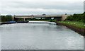
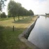
Mooring here is good (a nice place to moor). Nice safe place to moor with a built in BBQ and tables. Watch out for commercial boats coming through.

Pollington Lock No 133 miles, 4½ furlongs
Pollington Bridge 3 miles, 2¾ furlongs
Heck Railway Bridge No 20 2 miles, ½ furlongs
Heck Bridge Marina1 mile, 3¾ furlongs
Heck Bridge 1 mile, 2¾ furlongs
Whitley Lock Visitor Moorings 
Whitley Lock No 12    ½ furlongs
Whitley M62 Bridge No 191½ furlongs
A19 Whitley Bridge4½ furlongs
Whitley Pipe Bridge5¾ furlongs
Selby Road Bridge6¼ furlongs
 
 
Amenities

Amenities here

 Colin Welsh
 Bus stop (George And Dragon)
 Bus stop (George And Dragon)
 Bus stop (Gravelhill Lane)
 Bus stop (Gravelhill Lane)

Amenities nearby at Whitley Lock No 12

 Bus stop (Church Row)
 
Maps
If you are a user and are logged on, or if you are actively planning a route, a map will be displayed here.
Show on external mapping site: Google | OSM | Bing
 
Photos
 
External websites
There are no links to external websites from here.
Why not log in and add some (select "External websites" from the menu (sometimes this is under "Edit"))?
 
Nearest facilities

Mouseover for more information or show routes to facility

Nearest water point

In the direction of Castleford Junction

Whitley Lock No 12 — ½ furlongs away
On this waterway in the direction of Castleford Junction
Bank Dole Lock No 1 — 4 miles, 2 furlongs and 1 lock away
Travel to Bank Dole Junction, then on the Aire and Calder Navigation (Selby Section) to Bank Dole Lock No 1
Ferrybridge Flood Lock No 11 — 5 miles, 4½ furlongs and 1 lock away
On this waterway in the direction of Castleford Junction
Beal Bridge — 6 miles, 4¼ furlongs and 2 locks away
Travel to Bank Dole Junction, then on the Aire and Calder Navigation (Selby Section) to Beal Bridge
Beal Lock No 2 — 6 miles, 5¾ furlongs and 2 locks away
Travel to Bank Dole Junction, then on the Aire and Calder Navigation (Selby Section) to Beal Lock No 2
Bulholme Lock No 10 — 10 miles, 2½ furlongs and 2 locks away
On this waterway in the direction of Castleford Junction
Castleford Sanitary Station — 10 miles, 7¼ furlongs and 3 locks away
On this waterway in the direction of Castleford Junction
Woodnook Lock No 6 — 13 miles, 1¾ furlongs and 4 locks away
Travel to Castleford Junction, then on the Aire and Calder Navigation (Wakefield Section) to Woodnook Lock No 6
Fairies Hill Moorings — 13 miles, ½ furlongs and 5 locks away
Travel to Castleford Junction, then on the Aire and Calder Navigation (Wakefield Section) to Fairies Hill Lock Junction, then on the Aire and Calder Navigation (Fairies Hill Mooring Arm) to Fairies Hill Moorings
Lemonroyd Lock No 7 — 14 miles, 3½ furlongs and 4 locks away
Travel to Castleford Junction, then on the Aire and Calder Navigation (Main Line - Castleford to Leeds) to Lemonroyd Lock No 7
Selby Basin — 15 miles, 2½ furlongs and 4 locks away
Travel to Bank Dole Junction, then on the Aire and Calder Navigation (Selby Section) to Selby Basin
Lemonroyd Marina — 14 miles, 4½ furlongs and 5 locks away
Travel to Castleford Junction, then on the Aire and Calder Navigation (Main Line - Castleford to Leeds) to Lemonroyd Marina
King's Road Lock No 3 — 14 miles, 3¼ furlongs and 5 locks away
Travel to Castleford Junction, then on the Aire and Calder Navigation (Wakefield Section) to King's Road Lock No 3

In the direction of Ouse - Aire and Calder Junction

Pollington Visitor Mooring — 3 miles, 6 furlongs and 1 lock away
On this waterway in the direction of Ouse - Aire and Calder Junction
Goole CRT Visitor Moorings — 12 miles, ¼ furlongs and 1 lock away
On this waterway in the direction of Ouse - Aire and Calder Junction
Bramwith Lock No 14 — 11 miles, 4½ furlongs and 2 locks away
Travel to Sykehouse Junction, then on the Sheffield and South Yorkshire Navigation (New Junction Canal) to Bramwith Junction, then on the Sheffield and South Yorkshire Navigation (Bramwith to Stainforth) to Bramwith Lock No 14
Barnby Dun Lift Bridge — 12 miles, 2¾ furlongs and 2 locks away
Travel to Sykehouse Junction, then on the Sheffield and South Yorkshire Navigation (New Junction Canal) to Bramwith Junction, then on the Sheffield and South Yorkshire Navigation (Main Line) to Barnby Dun Lift Bridge
Bramwith Swing Bridge — 11 miles, 7¼ furlongs and 3 locks away
Travel to Sykehouse Junction, then on the Sheffield and South Yorkshire Navigation (New Junction Canal) to Bramwith Junction, then on the Sheffield and South Yorkshire Navigation (Bramwith to Stainforth) to Bramwith Swing Bridge
Long Sandall Lock No 13 — 14 miles, 4¼ furlongs and 2 locks away
Travel to Sykehouse Junction, then on the Sheffield and South Yorkshire Navigation (New Junction Canal) to Bramwith Junction, then on the Sheffield and South Yorkshire Navigation (Main Line) to Long Sandall Lock No 13
Thorne Visitor Moorings — 16 miles, 2 furlongs and 4 locks away
Travel to Sykehouse Junction, then on the Sheffield and South Yorkshire Navigation (New Junction Canal) to Bramwith Junction, then on the Sheffield and South Yorkshire Navigation (Bramwith to Stainforth) to Stainforth Junction, then on the Sheffield and South Yorkshire Navigation (Stainforth and Keadby Canal) to Thorne Visitor Moorings

Nearest rubbish disposal

In the direction of Castleford Junction

Whitley Lock No 12 — ½ furlongs away
On this waterway in the direction of Castleford Junction
Castleford Sanitary Station — 10 miles, 7¼ furlongs and 3 locks away
On this waterway in the direction of Castleford Junction
Selby Basin — 15 miles, 2½ furlongs and 4 locks away
Travel to Bank Dole Junction, then on the Aire and Calder Navigation (Selby Section) to Selby Basin
Lemonroyd Marina — 14 miles, 4½ furlongs and 5 locks away
Travel to Castleford Junction, then on the Aire and Calder Navigation (Main Line - Castleford to Leeds) to Lemonroyd Marina
Woodlesford Lock No 5 — 15 miles, 6¼ furlongs and 5 locks away
Travel to Castleford Junction, then on the Aire and Calder Navigation (Main Line - Castleford to Leeds) to Woodlesford Lock No 5
Ramsdens Bridge Visitor Moorings — 16 miles, ¾ furlongs and 7 locks away
Travel to Castleford Junction, then on the Aire and Calder Navigation (Wakefield Section) to Ramsdens Bridge Visitor Moorings
Ramsdens Swing Bridge — 16 miles, 1 furlong and 7 locks away
Travel to Castleford Junction, then on the Aire and Calder Navigation (Wakefield Section) to Ramsdens Swing Bridge

In the direction of Ouse - Aire and Calder Junction

Goole CRT Visitor Moorings — 12 miles, ¼ furlongs and 1 lock away
On this waterway in the direction of Ouse - Aire and Calder Junction
Barnby Dun Lift Bridge — 12 miles, 2¾ furlongs and 2 locks away
Travel to Sykehouse Junction, then on the Sheffield and South Yorkshire Navigation (New Junction Canal) to Bramwith Junction, then on the Sheffield and South Yorkshire Navigation (Main Line) to Barnby Dun Lift Bridge
Bramwith Swing Bridge — 11 miles, 7¼ furlongs and 3 locks away
Travel to Sykehouse Junction, then on the Sheffield and South Yorkshire Navigation (New Junction Canal) to Bramwith Junction, then on the Sheffield and South Yorkshire Navigation (Bramwith to Stainforth) to Bramwith Swing Bridge
Thorne Visitor Moorings — 16 miles, 2 furlongs and 4 locks away
Travel to Sykehouse Junction, then on the Sheffield and South Yorkshire Navigation (New Junction Canal) to Bramwith Junction, then on the Sheffield and South Yorkshire Navigation (Bramwith to Stainforth) to Stainforth Junction, then on the Sheffield and South Yorkshire Navigation (Stainforth and Keadby Canal) to Thorne Visitor Moorings
Doncaster Visitor Pontoon Moorings — 17 miles, 5¾ furlongs and 3 locks away
Travel to Sykehouse Junction, then on the Sheffield and South Yorkshire Navigation (New Junction Canal) to Bramwith Junction, then on the Sheffield and South Yorkshire Navigation (Main Line) to Doncaster Visitor Pontoon Moorings

Nearest chemical toilet disposal

In the direction of Castleford Junction

Whitley Lock No 12 — ½ furlongs away
On this waterway in the direction of Castleford Junction
Castleford Sanitary Station — 10 miles, 7¼ furlongs and 3 locks away
On this waterway in the direction of Castleford Junction
Fairies Hill Moorings — 13 miles, ½ furlongs and 5 locks away
Travel to Castleford Junction, then on the Aire and Calder Navigation (Wakefield Section) to Fairies Hill Lock Junction, then on the Aire and Calder Navigation (Fairies Hill Mooring Arm) to Fairies Hill Moorings
Selby Basin — 15 miles, 2½ furlongs and 4 locks away
Travel to Bank Dole Junction, then on the Aire and Calder Navigation (Selby Section) to Selby Basin
Lemonroyd Marina — 14 miles, 4½ furlongs and 5 locks away
Travel to Castleford Junction, then on the Aire and Calder Navigation (Main Line - Castleford to Leeds) to Lemonroyd Marina
Ramsdens Bridge Sanitary Station — 16 miles, 1 furlong and 7 locks away
Travel to Castleford Junction, then on the Aire and Calder Navigation (Wakefield Section) to Ramsdens Bridge Sanitary Station

In the direction of Ouse - Aire and Calder Junction

Goole CRT Visitor Moorings — 12 miles, ¼ furlongs and 1 lock away
On this waterway in the direction of Ouse - Aire and Calder Junction
Barnby Dun Lift Bridge — 12 miles, 2¾ furlongs and 2 locks away
Travel to Sykehouse Junction, then on the Sheffield and South Yorkshire Navigation (New Junction Canal) to Bramwith Junction, then on the Sheffield and South Yorkshire Navigation (Main Line) to Barnby Dun Lift Bridge
Bramwith Swing Bridge — 11 miles, 7¼ furlongs and 3 locks away
Travel to Sykehouse Junction, then on the Sheffield and South Yorkshire Navigation (New Junction Canal) to Bramwith Junction, then on the Sheffield and South Yorkshire Navigation (Bramwith to Stainforth) to Bramwith Swing Bridge
Thorne Visitor Moorings — 16 miles, 2 furlongs and 4 locks away
Travel to Sykehouse Junction, then on the Sheffield and South Yorkshire Navigation (New Junction Canal) to Bramwith Junction, then on the Sheffield and South Yorkshire Navigation (Bramwith to Stainforth) to Stainforth Junction, then on the Sheffield and South Yorkshire Navigation (Stainforth and Keadby Canal) to Thorne Visitor Moorings

Nearest place to turn

In the direction of Castleford Junction

Bank Dole Lock Junction — 4 miles, 2¼ furlongs and 2 locks away
Travel to Bank Dole Junction, then on the Aire and Calder Navigation (Selby Section) to Bank Dole Lock Junction
Ferrybridge Lock Visitor Mooring — 5 miles, 4 furlongs and 1 lock away
On this waterway in the direction of Castleford Junction
Beal Lock No 2 Weir Entrance — 6 miles, 4¾ furlongs and 2 locks away
Travel to Bank Dole Junction, then on the Aire and Calder Navigation (Selby Section) to Beal Lock No 2 Weir Entrance
Bulholme Lock Weir Exit — 10 miles, 2 furlongs and 2 locks away
On this waterway in the direction of Castleford Junction
Haddlesey Junction — 10 miles, 4 furlongs and 3 locks away
Travel to Bank Dole Junction, then on the Aire and Calder Navigation (Selby Section) to Haddlesey Junction
Lemonroyd Lock Weir Exit — 14 miles, 2½ furlongs and 4 locks away
Travel to Castleford Junction, then on the Aire and Calder Navigation (Main Line - Castleford to Leeds) to Lemonroyd Lock Weir Exit
Fairies Hill Lock Arm — 13 miles, 3¼ furlongs and 5 locks away
Travel to Castleford Junction, then on the Aire and Calder Navigation (Wakefield Section) to Fairies Hill Lock Arm
Selby Basin — 15 miles, 2½ furlongs and 4 locks away
Travel to Bank Dole Junction, then on the Aire and Calder Navigation (Selby Section) to Selby Basin
Fleet Lane Arm — 14 miles, 6¾ furlongs and 5 locks away
Travel to Castleford Junction, then on the Aire and Calder Navigation (Main Line - Castleford to Leeds) to Fleet Lane Arm
Stanley Ferry Marina — 15 miles, 7¾ furlongs and 7 locks away
Travel to Castleford Junction, then on the Aire and Calder Navigation (Wakefield Section) to Stanley Ferry Marina
Junction with River Aire (Old Channel) South — 19 miles, 1 furlong and 7 locks away
Travel to Castleford Junction, then on the Aire and Calder Navigation (Main Line - Castleford to Leeds) to Junction with River Aire (Old Channel) South
Junction with River Aire (Old Channel) North — 19 miles, 6 furlongs and 8 locks away
Travel to Castleford Junction, then on the Aire and Calder Navigation (Main Line - Castleford to Leeds) to Junction with River Aire (Old Channel) North
Knostrop Flood Lock Weir Entrance — 19 miles, 6¼ furlongs and 8 locks away
Travel to Castleford Junction, then on the Aire and Calder Navigation (Main Line - Castleford to Leeds) to Knostrop Flood Lock Weir Entrance
Wakefield Weir Entrance — 19 miles and 9 locks away
Travel to Castleford Junction, then on the Aire and Calder Navigation (Wakefield Section) to Fall Ing Junction, then on the Calder and Hebble Navigation (Main Line) to Wakefield Weir Entrance

In the direction of Ouse - Aire and Calder Junction

Pollington Visitor Mooring — 3 miles, 6 furlongs and 1 lock away
On this waterway in the direction of Ouse - Aire and Calder Junction
Viking Marina — 12 miles, ¾ furlongs and 1 lock away
On this waterway in the direction of Ouse - Aire and Calder Junction
Huddle Grounds Winding Hole — 13 miles, 6½ furlongs and 3 locks away
Travel to Sykehouse Junction, then on the Sheffield and South Yorkshire Navigation (New Junction Canal) to Bramwith Junction, then on the Sheffield and South Yorkshire Navigation (Bramwith to Stainforth) to Stainforth Junction, then on the Sheffield and South Yorkshire Navigation (Stainforth and Keadby Canal) to Huddle Grounds Winding Hole
Wheatley Hall Road Winding Hole — 15 miles, 4¾ furlongs and 3 locks away
Travel to Sykehouse Junction, then on the Sheffield and South Yorkshire Navigation (New Junction Canal) to Bramwith Junction, then on the Sheffield and South Yorkshire Navigation (Main Line) to Wheatley Hall Road Winding Hole
Gas House Bight — 17 miles, 4 furlongs and 3 locks away
Travel to Sykehouse Junction, then on the Sheffield and South Yorkshire Navigation (New Junction Canal) to Bramwith Junction, then on the Sheffield and South Yorkshire Navigation (Main Line) to Gas House Bight
Doncaster Visitor Pontoon Moorings — 17 miles, 5¾ furlongs and 3 locks away
Travel to Sykehouse Junction, then on the Sheffield and South Yorkshire Navigation (New Junction Canal) to Bramwith Junction, then on the Sheffield and South Yorkshire Navigation (Main Line) to Doncaster Visitor Pontoon Moorings

Nearest self-operated pump-out

In the direction of Castleford Junction

Castleford Sanitary Station — 10 miles, 7¼ furlongs and 3 locks away
On this waterway in the direction of Castleford Junction
Ramsdens Bridge Sanitary Station — 16 miles, 1 furlong and 7 locks away
Travel to Castleford Junction, then on the Aire and Calder Navigation (Wakefield Section) to Ramsdens Bridge Sanitary Station

In the direction of Ouse - Aire and Calder Junction

Long Sandall Lock No 13 — 14 miles, 4¼ furlongs and 2 locks away
Travel to Sykehouse Junction, then on the Sheffield and South Yorkshire Navigation (New Junction Canal) to Bramwith Junction, then on the Sheffield and South Yorkshire Navigation (Main Line) to Long Sandall Lock No 13
Direction of TV transmitter (From Wolfbane Cybernetic)
 
 
Geograph
 
Wikipedia

There is no page on Wikipedia called “Whitley Lock Visitor Moorings”

Wikipedia pages that might relate to Whitley Lock Visitor Moorings
[Burghfield] annexe attached, in Whitley, South of Kirton's Farm Road, South-West of Reading. Two type 28a anti-tank gun emplacements at Garston Lock, Kennet and Avon
 
Google

Results of Google Search

Whitley Lock L1 :: Waterside Moorings
Whitley Lock is situated on the Aire & Calder main line and is a short drive from from the market town of Selby. The site comprises linear moorings above and ...
Aire and Calder overnight moorings - General Boating - Canal World
Jan 5, 2013 ... Is it easy to find space at the visitor moorings? ... unless I've missed it is the VM at Whitley lock - no pub nearby but very pleasant moorings with ...
Lincoln to Leeds and Back again | YBW Forum
Apr 24, 2012 ... Before long we were at the next massive lock, Whitley Lock. ... Within minutes we were safely tucked up on the visitor moorings in Clarence ...
Amber! 20th March | NB Oleanna
Mar 22, 2019 ... Pollington to Whitley Visitor Moorings ... We were uncertain as to whether both boats would fit in the lock at once, I walked ahead and left Mick ...
The 1999 Tour Page 4
... dinner as we intended to stop on the visitor moorings below Whitley Lock. You don't stop on un protected moorings without rings on the Aire and Calder, ...
Visitor Moorings
IWA supports the provision of a mix of visitor moorings with different time periods, ... lock to maintain a fixed water level or protection from floods or with mooring ...