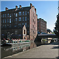
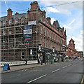
Carrington Street Bridge
Nottingham
Crunch Munch, 48a Carrington Street, Nottingham NG1 7FG, United Kingdom

Carrington Street Bridge
is a city
on the River Trent (Nottingham Canal) between
Meadow Lane Junction (Junction of Nottingham Canal with River Trent) (4½ furlongs
and 1 lock
to the southeast) and
Lenton Chain (Junction of Nottingham and Beeston Canals. The Nottingham Canal used to continue north to Langley Mill from here.) (5¾ furlongs
and 1 lock
to the west).
The nearest place in the direction of Meadow Lane Junction is Nottingham Tram Railway Bridge;
½ furlongs
away.
The nearest place in the direction of Lenton Chain is Canal Museum Arm;
¼ furlongs
away.
There may be access to the towpath here.
Mooring here is unrated.
There is a bridge here which takes a road over the canal.
Poplar Arms Corner | 1½ furlongs | |
London Road Bridge | 1¼ furlongs | |
Boots Pipe Bridge | ¾ furlongs | |
Trent Street Bridge | ½ furlongs | |
Nottingham Tram Railway Bridge | ½ furlongs | |
Carrington Street Bridge | ||
Canal Museum Arm | ¼ furlongs | |
Canal Museum Wharf | ¼ furlongs | |
Nottingham Wharf Arm (closed) | ¼ furlongs | |
Wilford Street Footbridge | ½ furlongs | |
Wilford Street Bridge No 16 | ¾ furlongs |
Amenities here
Amenities nearby at Canal Museum Arm
Amenities nearby at Nottingham Tram Railway Bridge
Amenities in Nottingham
Amenities at other places in Nottingham
at
at
at
at
at
at
at
at
at
at
at
at
at
at
at
at
at
at
at
at
at
at
at
at
at
at
at
at
at
at
at
at
at
at
at
at
at
at
at
at
at
at
at
at
at
at
at
at
at
at
at
There are no links to external websites from here.
Why not log in and add some (select "External websites" from the menu (sometimes this is under "Edit"))?
Mouseover for more information or show routes to facility
Nearest water point
In the direction of Lenton Chain
Beeston Lock No 5 — 5 miles, 2¾ furlongs and 1 lock away
Travel to Lenton Chain, then on the River Trent (Beeston Canal) to Beeston Lock No 5
Cranfleet Lock No 3 — 9 miles, 5¼ furlongs and 2 locks away
Travel to Lenton Chain, then on the River Trent (Beeston Canal) to Beeston Lock No 5, then on the River Trent (Western End) to Cranfleet Lock No 3
Former BW Trent Lock Waterway Office — 10 miles, 3¾ furlongs and 5 locks away
Travel to Lenton Chain, then on the River Trent (Beeston Canal) to Beeston Lock No 5, then on the River Trent (Western End) to Trent Junction, then on the Grand Union Canal (Erewash Canal) to Former BW Trent Lock Waterway Office
Sawley Locks No 2 — 11 miles, 1¾ furlongs and 4 locks away
Travel to Lenton Chain, then on the River Trent (Beeston Canal) to Beeston Lock No 5, then on the River Trent (Western End) to Sawley Locks No 2
Shardlow — 13 miles, 3½ furlongs and 7 locks away
Travel to Lenton Chain, then on the River Trent (Beeston Canal) to Beeston Lock No 5, then on the River Trent (Western End) to Derwent Mouth, then on the Trent and Mersey Canal (Main Line - Derwent Mouth to Burton) to Shardlow
Weston Lock No 4 — 16 miles, 3 furlongs and 9 locks away
Travel to Lenton Chain, then on the River Trent (Beeston Canal) to Beeston Lock No 5, then on the River Trent (Western End) to Derwent Mouth, then on the Trent and Mersey Canal (Main Line - Derwent Mouth to Burton) to Weston Lock No 4
Bishop Meadow Lock No 54 — 18 miles, 3¾ furlongs and 9 locks away
Travel to Lenton Chain, then on the River Trent (Beeston Canal) to Beeston Lock No 5, then on the River Trent (Western End) to Trent Junction, then on the Grand Union Canal (Leicester Section - River Soar Navigation) to Bishop Meadow Lock No 54
Swarkestone Lock No 5 — 19 miles, 2¼ furlongs and 10 locks away
Travel to Lenton Chain, then on the River Trent (Beeston Canal) to Beeston Lock No 5, then on the River Trent (Western End) to Derwent Mouth, then on the Trent and Mersey Canal (Main Line - Derwent Mouth to Burton) to Swarkestone Lock No 5
Loughborough Basin — 19 miles, 4½ furlongs and 11 locks away
Travel to Lenton Chain, then on the River Trent (Beeston Canal) to Beeston Lock No 5, then on the River Trent (Western End) to Trent Junction, then on the Grand Union Canal (Leicester Section - River Soar Navigation) to Loughborough Branch Junction, then on the Grand Union Canal (Leicester Section - Loughborough Branch) to Loughborough Basin
In the direction of Meadow Lane Junction
Holme Lock No 5 — 2 miles, 7¾ furlongs and 1 lock away
Travel to Meadow Lane Junction, then on the River Trent (non-tidal section) to Holme Lock No 5
Stoke Lock No 6 — 6 miles and 2 locks away
Travel to Meadow Lane Junction, then on the River Trent (non-tidal section) to Stoke Lock No 6
Gunthorpe Lock No 7 — 10 miles, 6 furlongs and 3 locks away
Travel to Meadow Lane Junction, then on the River Trent (non-tidal section) to Gunthorpe Lock No 7
Hazelford Lock No 8 — 15 miles, 4 furlongs and 4 locks away
Travel to Meadow Lane Junction, then on the River Trent (non-tidal section) to Hazelford Lock No 8Nearest rubbish disposal
In the direction of Lenton Chain
Beeston Lock No 5 — 5 miles, 2¾ furlongs and 1 lock away
Travel to Lenton Chain, then on the River Trent (Beeston Canal) to Beeston Lock No 5
Cranfleet Lock No 3 — 9 miles, 5¼ furlongs and 2 locks away
Travel to Lenton Chain, then on the River Trent (Beeston Canal) to Beeston Lock No 5, then on the River Trent (Western End) to Cranfleet Lock No 3
Former BW Trent Lock Waterway Office — 10 miles, 3¾ furlongs and 5 locks away
Travel to Lenton Chain, then on the River Trent (Beeston Canal) to Beeston Lock No 5, then on the River Trent (Western End) to Trent Junction, then on the Grand Union Canal (Erewash Canal) to Former BW Trent Lock Waterway Office
Sawley Locks No 2 — 11 miles, 1¾ furlongs and 4 locks away
Travel to Lenton Chain, then on the River Trent (Beeston Canal) to Beeston Lock No 5, then on the River Trent (Western End) to Sawley Locks No 2
Swarkestone Lock No 5 — 19 miles, 2¼ furlongs and 10 locks away
Travel to Lenton Chain, then on the River Trent (Beeston Canal) to Beeston Lock No 5, then on the River Trent (Western End) to Derwent Mouth, then on the Trent and Mersey Canal (Main Line - Derwent Mouth to Burton) to Swarkestone Lock No 5
Loughborough Basin — 19 miles, 4½ furlongs and 11 locks away
Travel to Lenton Chain, then on the River Trent (Beeston Canal) to Beeston Lock No 5, then on the River Trent (Western End) to Trent Junction, then on the Grand Union Canal (Leicester Section - River Soar Navigation) to Loughborough Branch Junction, then on the Grand Union Canal (Leicester Section - Loughborough Branch) to Loughborough Basin
In the direction of Meadow Lane Junction
Holme Lock No 5 — 2 miles, 7¾ furlongs and 1 lock away
Travel to Meadow Lane Junction, then on the River Trent (non-tidal section) to Holme Lock No 5
Stoke Lock No 6 — 6 miles and 2 locks away
Travel to Meadow Lane Junction, then on the River Trent (non-tidal section) to Stoke Lock No 6
Gunthorpe Lock No 7 — 10 miles, 6 furlongs and 3 locks away
Travel to Meadow Lane Junction, then on the River Trent (non-tidal section) to Gunthorpe Lock No 7
Hazelford Lock No 8 — 15 miles, 4 furlongs and 4 locks away
Travel to Meadow Lane Junction, then on the River Trent (non-tidal section) to Hazelford Lock No 8Nearest chemical toilet disposal
In the direction of Lenton Chain
Beeston Lock No 5 — 5 miles, 2¾ furlongs and 1 lock away
Travel to Lenton Chain, then on the River Trent (Beeston Canal) to Beeston Lock No 5
Former BW Trent Lock Waterway Office — 10 miles, 3¾ furlongs and 5 locks away
Travel to Lenton Chain, then on the River Trent (Beeston Canal) to Beeston Lock No 5, then on the River Trent (Western End) to Trent Junction, then on the Grand Union Canal (Erewash Canal) to Former BW Trent Lock Waterway Office
Sawley Locks No 2 — 11 miles, 1¾ furlongs and 4 locks away
Travel to Lenton Chain, then on the River Trent (Beeston Canal) to Beeston Lock No 5, then on the River Trent (Western End) to Sawley Locks No 2
Sawley Cut Wharf — 11 miles, 3¼ furlongs and 5 locks away
Travel to Lenton Chain, then on the River Trent (Beeston Canal) to Beeston Lock No 5, then on the River Trent (Western End) to Sawley Cut Wharf
In the direction of Meadow Lane Junction
Meadow Lane Lock No 7 — 4¼ furlongs away
On this waterway in the direction of Meadow Lane Junction
Holme Lock No 5 — 2 miles, 7¾ furlongs and 1 lock away
Travel to Meadow Lane Junction, then on the River Trent (non-tidal section) to Holme Lock No 5
Stoke Lock No 6 — 6 miles and 2 locks away
Travel to Meadow Lane Junction, then on the River Trent (non-tidal section) to Stoke Lock No 6
Gunthorpe Lock No 7 — 10 miles, 6 furlongs and 3 locks away
Travel to Meadow Lane Junction, then on the River Trent (non-tidal section) to Gunthorpe Lock No 7Nearest place to turn
In the direction of Lenton Chain
Canal Museum Wharf — ¼ furlongs away
On this waterway in the direction of Lenton Chain
Redfield Road Bridge Winding Hole — 2 miles, ¼ furlongs and 1 lock away
Travel to Lenton Chain, then on the River Trent (Beeston Canal) to Redfield Road Bridge Winding Hole
Rylands Bridge Winding Hole — 4 miles, ½ furlongs and 1 lock away
Travel to Lenton Chain, then on the River Trent (Beeston Canal) to Rylands Bridge Winding Hole
Cranfleet Lock Weir Exit — 9 miles, 4½ furlongs and 2 locks away
Travel to Lenton Chain, then on the River Trent (Beeston Canal) to Beeston Lock No 5, then on the River Trent (Western End) to Cranfleet Lock Weir Exit
Soar Mouth — 10 miles, 4¼ furlongs and 4 locks away
Travel to Lenton Chain, then on the River Trent (Beeston Canal) to Beeston Lock No 5, then on the River Trent (Western End) to Trent Junction, then on the Grand Union Canal (Leicester Section - River Soar Navigation) to Soar Mouth
Redhill Lock Junction — 10 miles, 6¾ furlongs and 4 locks away
Travel to Lenton Chain, then on the River Trent (Beeston Canal) to Beeston Lock No 5, then on the River Trent (Western End) to Trent Junction, then on the Grand Union Canal (Leicester Section - River Soar Navigation) to Redhill Lock Junction
Sawley Lock No 2 Weir Exit — 11 miles, 1 furlong and 4 locks away
Travel to Lenton Chain, then on the River Trent (Beeston Canal) to Beeston Lock No 5, then on the River Trent (Western End) to Sawley Lock No 2 Weir Exit
Former BW Trent Lock Waterway Office — 10 miles, 3¾ furlongs and 5 locks away
Travel to Lenton Chain, then on the River Trent (Beeston Canal) to Beeston Lock No 5, then on the River Trent (Western End) to Trent Junction, then on the Grand Union Canal (Erewash Canal) to Former BW Trent Lock Waterway Office
Sheet Stores Basin — 11 miles, ¾ furlongs and 5 locks away
Travel to Lenton Chain, then on the River Trent (Beeston Canal) to Beeston Lock No 5, then on the River Trent (Western End) to Trent Junction, then on the Grand Union Canal (Erewash Canal) to Sheet Stores Basin
Redhill Marine Ltd — 11 miles, 3 furlongs and 5 locks away
Travel to Lenton Chain, then on the River Trent (Beeston Canal) to Beeston Lock No 5, then on the River Trent (Western End) to Trent Junction, then on the Grand Union Canal (Leicester Section - River Soar Navigation) to Redhill Marine Ltd
Ratcliffe Lock Junction — 11 miles, 5½ furlongs and 5 locks away
Travel to Lenton Chain, then on the River Trent (Beeston Canal) to Beeston Lock No 5, then on the River Trent (Western End) to Trent Junction, then on the Grand Union Canal (Leicester Section - River Soar Navigation) to Ratcliffe Lock Junction
Sawley Flood Lock Weir Entrance — 11 miles, 6¾ furlongs and 6 locks away
Travel to Lenton Chain, then on the River Trent (Beeston Canal) to Beeston Lock No 5, then on the River Trent (Western End) to Sawley Flood Lock Weir Entrance
Ratcliffe Weir — 12 miles, ½ furlongs and 6 locks away
Travel to Lenton Chain, then on the River Trent (Beeston Canal) to Beeston Lock No 5, then on the River Trent (Western End) to Trent Junction, then on the Grand Union Canal (Leicester Section - River Soar Navigation) to Ratcliffe Weir
Long Eaton Winding Hole — 12 miles, 2½ furlongs and 6 locks away
Travel to Lenton Chain, then on the River Trent (Beeston Canal) to Beeston Lock No 5, then on the River Trent (Western End) to Trent Junction, then on the Grand Union Canal (Erewash Canal) to Long Eaton Winding Hole
Derwent Mouth — 12 miles, 2¾ furlongs and 6 locks away
Travel to Lenton Chain, then on the River Trent (Beeston Canal) to Beeston Lock No 5, then on the River Trent (Western End) to Derwent Mouth
In the direction of Meadow Lane Junction
Poplar Arms Corner — 1½ furlongs away
On this waterway in the direction of Meadow Lane Junction
Holme Lock Weir Entrance — 2 miles, 6¼ furlongs and 1 lock away
Travel to Meadow Lane Junction, then on the River Trent (non-tidal section) to Holme Lock Weir Entrance
Holme Lock Weir Exit — 3 miles, 1 furlong and 2 locks away
Travel to Meadow Lane Junction, then on the River Trent (non-tidal section) to Holme Lock Weir Exit
Hazelford Lock East Weir Entrance — 14 miles, 6¾ furlongs and 4 locks away
Travel to Meadow Lane Junction, then on the River Trent (non-tidal section) to Hazelford Lock East Weir Entrance
Hazelford Ferry — 14 miles, 7¼ furlongs and 4 locks away
Travel to Meadow Lane Junction, then on the River Trent (non-tidal section) to Hazelford FerryNo information
CanalPlan has no information on any of the following facilities within range:self-operated pump-out
boatyard pump-out
Direction of TV transmitter (From Wolfbane Cybernetic)
There is no page on Wikipedia called “Carrington Street Bridge”
Wikipedia pages that might relate to Carrington Street Bridge
[Watendlath]
packhorse bridge was named 4th best bridge in England to play Poohsticks on. Watendlath is reached by a minor road from the Borrowdale road (B5289). The
[Stockton Bridge]
plan to build a bridge from North Carrington to Stockton was rejected as it would interfere with shipping. The Tourle Street bridge opened in early 1965
[A Bridge Too Far (film)]
road and bridges as far as Nijmegen. A British division, under Major-General Roy Urquhart, is to land near Arnhem and hold both sides of the bridge there
[Carrington Street, Nottingham]
1842 a bridge was constructed over the Nottingham and Beeston Canal to provide access to Nottingham Carrington Street railway station. The bridge costing
[Fetterman Fight]
hand-to-hand fight requiring the utmost caution." Carrington's guide, famous mountain man Jim Bridger, was more succinct: "These soldiers don't know anything
[St. Johns Bridge]
The St. Johns Bridge is a steel suspension bridge that spans the Willamette River in Portland, Oregon, United States, between the Cathedral Park neighborhood
[Barton Road Swing Bridge]
Barton Road Swing Bridge (or Barton Road Bridge) is a swing bridge for road traffic in Greater Manchester that crosses the Manchester Ship Canal between
[Lady Carrington Drive]
River, including Gibraltar Rock and Palona Cave. Originally named Lady Carrington Road, the trail took three years to build, starting in 1880 and completed
[Tunnels of Nottingham]
in the partly filled cutting off Haydn Road in Basford and its south portal at the north end of the Carrington Station cutting. The tunnel still exists
[A roads in Zone 6 of the Great Britain numbering scheme]
A roads in zone 6 in Great Britain starting east of the A6 and A7 roads, and west of the A1 (road beginning with 6). "A613 (Gateshead)". sabre-roads.org
Results of Google Search
Carrington Road Bridge Buoys | Canal & River TrustPlease be advised that the buoys at Carrington Road Bridge are no longer in position. We are currently working on a resolution and hope to have them back in  ...
Our Avalon preschool on Webb Bridge Road in Alpharetta combines learning experiences and structured play in a fun, safe and nurturing environment - offering ...
Lady Carrington Road, near Bola Creek bridge, [New South Wales]. [Sydney] : Govt. Printing Office, 1888. Title from index.; In the album: Photographs of The ...
May 10, 2019 ... Carrington Academy Students Hold Celebratory... - Alpharetta-Milton, GA - Students recognized Earth Day by releasing 36000 ladybugs in their ...
Carrington Street is a street in Nottingham city centre between Nottingham station and Broadmarsh. History[edit]. The street was laid out by Henry Moses Wood, Surveyor in 1828. The opportunity offered by the construction of this new road was taken to ... In 1842 a bridge was constructed over the Nottingham and Beeston Canal to ...
May 23, 2017 ... File:Lady Carrington Road, at Bola Creek bridge, (New South Wales). ( 6173943120).jpg. From Wikimedia Commons, the free media repository.
Looking for an LVN to RN program near you? The Carrington College nursing bridge program has classes starting soon at schools in California & Idaho. Learn  ...
Since the railway bridge over part of the Southern Link Road was extended at the end of May 2018, work to complete the dualling between Whittington and ...
Save Marrickville has two positions on the Carrington Rd Community ... affect all side roads leading onto Carrington including Unwin's Bridge Rd Tempe and ...
Aug 31, 2017 ... Install a bridge over Carrington Road. This is outside of the scope and budget for this project. Would like wider access point on ramps. Ramps ...