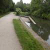
Tapton Slipway
is a minor waterways place
on the Chesterfield Canal (Derbyshire restored section) between
Chesterfield Waterside (New development under construction and limit of navigation) (7½ furlongs
and 1 lock
to the south) and
Staveley Town Lock No 5A (4 miles and 5 furlongs
and 4 locks
to the east).
The nearest place in the direction of Chesterfield Waterside is Lockoford Lane Bridge;
¼ furlongs
away.
The nearest place in the direction of Staveley Town Lock No 5A is Rother Way Railway Bridge No 2;
1¼ furlongs
away.
There is access (suitable for wheels) to the towpath here.
Mooring here is impossible (it may be physically impossible, forbidden, or allowed only for specific short-term purposes).
Tapton Mill Bridge | 3¾ furlongs | |
Rother Way Tunnel (southern entrance) | ¾ furlongs | |
Rother Way Tunnel (northern entrance) | ¾ furlongs | |
Tapton Lock No 1 | ½ furlongs | |
Lockoford Lane Bridge | ¼ furlongs | |
Tapton Slipway | ||
Rother Way Railway Bridge No 2 | 1¼ furlongs | |
Rother Way Railway Bridge No 1 | 1¾ furlongs | |
Brimington Wharf | 5¼ furlongs | |
Station Road Bridge (Brimington) | 5½ furlongs | |
Wheeldon Mill Lock No 2 | 7¼ furlongs |
- Chesterfield Canal Trust — associated with Chesterfield Canal (Derbyshire restored section)
- Restoration website
Mouseover for more information or show routes to facility
Nearest water point
In the direction of Staveley Town Basin
Shireoaks Marina — 16 miles, 4½ furlongs and 69 locks away
Travel to Staveley Town Basin, then on the Chesterfield Canal (Unnavigable section) to New Leah’s Bridge No 26B, then on the Chesterfield Canal (Central Line West) to Nethermoor Lake Marina, then on the Chesterfield Canal (Unnavigable section) to Norwood Tunnel (eastern entrance), then on the Chesterfield Canal (Norwood to Retford) to Shireoaks MarinaNearest rubbish disposal
In the direction of Staveley Town Basin
Shireoaks Marina — 16 miles, 4½ furlongs and 69 locks away
Travel to Staveley Town Basin, then on the Chesterfield Canal (Unnavigable section) to New Leah’s Bridge No 26B, then on the Chesterfield Canal (Central Line West) to Nethermoor Lake Marina, then on the Chesterfield Canal (Unnavigable section) to Norwood Tunnel (eastern entrance), then on the Chesterfield Canal (Norwood to Retford) to Shireoaks MarinaNearest chemical toilet disposal
In the direction of Staveley Town Basin
Shireoaks Marina — 16 miles, 4½ furlongs and 69 locks away
Travel to Staveley Town Basin, then on the Chesterfield Canal (Unnavigable section) to New Leah’s Bridge No 26B, then on the Chesterfield Canal (Central Line West) to Nethermoor Lake Marina, then on the Chesterfield Canal (Unnavigable section) to Norwood Tunnel (eastern entrance), then on the Chesterfield Canal (Norwood to Retford) to Shireoaks Marina
Cuckoo Wharf Elsan — 18 miles, 6¼ furlongs and 78 locks away
Travel to Staveley Town Basin, then on the Chesterfield Canal (Unnavigable section) to New Leah’s Bridge No 26B, then on the Chesterfield Canal (Central Line West) to Nethermoor Lake Marina, then on the Chesterfield Canal (Unnavigable section) to Norwood Tunnel (eastern entrance), then on the Chesterfield Canal (Norwood to Retford) to Cuckoo Wharf ElsanNearest place to turn
In the direction of Staveley Town Basin
Bilby Lane Bridge Winding Hole — 1 mile, 7¾ furlongs and 2 locks away
On this waterway in the direction of Staveley Town Basin
Works Road Winding Hole — 3 miles, 1 furlong and 4 locks away
On this waterway in the direction of Staveley Town Basin
Staveley Town Basin — 4 miles, 4½ furlongs and 4 locks away
On this waterway in the direction of Staveley Town Basin
Hartington Harbour — 4 miles, 6 furlongs and 5 locks away
Travel to Staveley Town Basin, then on the Chesterfield Canal (Unnavigable section) to Hartington Harbour
Norwood Winding Hole — 10 miles, 5½ furlongs and 20 locks away
Travel to Staveley Town Basin, then on the Chesterfield Canal (Unnavigable section) to New Leah’s Bridge No 26B, then on the Chesterfield Canal (Central Line West) to Nethermoor Lake Marina, then on the Chesterfield Canal (Unnavigable section) to Norwood Winding Hole
Kiveton Waters Marina — 12 miles, 1½ furlongs and 43 locks away
Travel to Staveley Town Basin, then on the Chesterfield Canal (Unnavigable section) to New Leah’s Bridge No 26B, then on the Chesterfield Canal (Central Line West) to Nethermoor Lake Marina, then on the Chesterfield Canal (Unnavigable section) to Kiveton Waters Marina
Manor Road Winding Hole — 13 miles and 46 locks away
Travel to Staveley Town Basin, then on the Chesterfield Canal (Unnavigable section) to New Leah’s Bridge No 26B, then on the Chesterfield Canal (Central Line West) to Nethermoor Lake Marina, then on the Chesterfield Canal (Unnavigable section) to Norwood Tunnel (eastern entrance), then on the Chesterfield Canal (Norwood to Retford) to Manor Road Winding Hole
Little Lane Bridge Winding Hole — 15 miles, 5 furlongs and 61 locks away
Travel to Staveley Town Basin, then on the Chesterfield Canal (Unnavigable section) to New Leah’s Bridge No 26B, then on the Chesterfield Canal (Central Line West) to Nethermoor Lake Marina, then on the Chesterfield Canal (Unnavigable section) to Norwood Tunnel (eastern entrance), then on the Chesterfield Canal (Norwood to Retford) to Little Lane Bridge Winding Hole
Shireoaks Marina — 16 miles, 4½ furlongs and 69 locks away
Travel to Staveley Town Basin, then on the Chesterfield Canal (Unnavigable section) to New Leah’s Bridge No 26B, then on the Chesterfield Canal (Central Line West) to Nethermoor Lake Marina, then on the Chesterfield Canal (Unnavigable section) to Norwood Tunnel (eastern entrance), then on the Chesterfield Canal (Norwood to Retford) to Shireoaks Marina
Junction with former Lady Lee Arm — 17 miles, 7¼ furlongs and 76 locks away
Travel to Staveley Town Basin, then on the Chesterfield Canal (Unnavigable section) to New Leah’s Bridge No 26B, then on the Chesterfield Canal (Central Line West) to Nethermoor Lake Marina, then on the Chesterfield Canal (Unnavigable section) to Norwood Tunnel (eastern entrance), then on the Chesterfield Canal (Norwood to Retford) to Junction with former Lady Lee Arm
Morse Lock Winding Hole — 18 miles, 3½ furlongs and 77 locks away
Travel to Staveley Town Basin, then on the Chesterfield Canal (Unnavigable section) to New Leah’s Bridge No 26B, then on the Chesterfield Canal (Central Line West) to Nethermoor Lake Marina, then on the Chesterfield Canal (Unnavigable section) to Norwood Tunnel (eastern entrance), then on the Chesterfield Canal (Norwood to Retford) to Morse Lock Winding Hole
High Hoe Road Bridge Winding Hole — 19 miles, 3½ furlongs and 79 locks away
Travel to Staveley Town Basin, then on the Chesterfield Canal (Unnavigable section) to New Leah’s Bridge No 26B, then on the Chesterfield Canal (Central Line West) to Nethermoor Lake Marina, then on the Chesterfield Canal (Unnavigable section) to Norwood Tunnel (eastern entrance), then on the Chesterfield Canal (Norwood to Retford) to High Hoe Road Bridge Winding HoleNo information
CanalPlan has no information on any of the following facilities within range:self-operated pump-out
boatyard pump-out
Direction of TV transmitter (From Wolfbane Cybernetic)
There is no page on Wikipedia called “Tapton Slipway”
Wikipedia pages that might relate to Tapton Slipway
[Robert Stephenson]
pleurisy in the cabin of the packet bound for Southampton. He retired to Tapton House, near Chesterfield, and married his housekeeper early in 1848. Later