
Keadby Junction
Junction of Stainforth and Keadby Canal with River Trent
Station Road, Keadby DN17 3BP, United Kingdom

Keadby Junction
is a major waterways place
at the junction of
the Sheffield and South Yorkshire Navigation (Stainforth and Keadby Canal)
with
the River Trent (tidal section - Cromwell to Keadby)
and
the River Trent (tidal section - Keadby to Trent Falls).
Keadby Visitor Moorings
is on
the Sheffield and South Yorkshire Navigation (Stainforth and Keadby Canal),
1¼ furlongs
and 1 lock
to the west.
West Butterwick
is on
the River Trent (tidal section - Cromwell to Keadby),
4 miles
to the south.
Trent Falls (Rivers Trent and Ouse (Yorkshire) merge to form the River Humber.)
is on
the River Trent (tidal section - Keadby to Trent Falls),
9 miles
to the northeast.
The nearest place in the direction of Keadby Visitor Moorings is Keadby Junction Lock;
½ furlongs
away.
The nearest place in the direction of West Butterwick is Keadby Bridge (A single railway and road bascule bridge);
4½ furlongs
away.
The nearest place in the direction of Trent Falls is Arncotts and Flixborough Stather;
2 miles and 6 furlongs
away.
Mooring here is impossible (it may be physically impossible, forbidden, or allowed only for specific short-term purposes). There is nowhere to moor here at all. You have to make sure the lock keeper is expecting you with at least 24 hours notice.
Sheffield and South Yorkshire Navigation (Stainforth and Keadby Canal) | ||
---|---|---|
Pilfrey Bridge | 1 mile, 4 furlongs | |
Vazon Road Swing Bridge | 5½ furlongs | |
Vazon Sliding Railway Bridge | 5 furlongs | |
Keadby Visitor Moorings | 1¼ furlongs | |
Trentside Swing Bridge | ¾ furlongs | |
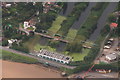
Keadby Junction Lock | ½ furlongs | |
Keadby Junction | ||
River Trent (tidal section - Cromwell to Keadby) | ||
Keadby Junction | ||
Keadby Bridge | 4½ furlongs | |
Burringham and Althorpe | 1 mile, 3½ furlongs | |
Derrythorpe | 2 miles, ¼ furlongs | |
M180 Bridge | 2 miles, 7 furlongs | |
West Butterwick | 4 miles | |
River Trent (tidal section - Keadby to Trent Falls) | ||
Keadby Junction | ||
Arncotts and Flixborough Stather | 2 miles, 6 furlongs | |
Burton upon Stather | 5 miles, 6¼ furlongs | |
Trent Falls | 9 miles |
- S&SY navigation info — associated with Sheffield and South Yorkshire Navigation
- Sheffield & South Yorkshire navigation info from IWA
Mouseover for more information or show routes to facility
Nearest water point
In the direction of Stainforth Junction
Keadby Visitor Moorings — 1¼ furlongs and 1 lock away
On the Sheffield and South Yorkshire Navigation (Stainforth and Keadby Canal) in the direction of Stainforth Junction
Thorne Visitor Moorings — 9 miles, 7½ furlongs and 1 lock away
On the Sheffield and South Yorkshire Navigation (Stainforth and Keadby Canal) in the direction of Stainforth Junction
Bramwith Swing Bridge — 14 miles, 2¼ furlongs and 2 locks away
Travel to Stainforth Junction, then on the Sheffield and South Yorkshire Navigation (Bramwith to Stainforth) to Bramwith Swing Bridge
Bramwith Lock No 14 — 14 miles, 5 furlongs and 2 locks away
Travel to Stainforth Junction, then on the Sheffield and South Yorkshire Navigation (Bramwith to Stainforth) to Bramwith Lock No 14
Barnby Dun Lift Bridge — 15 miles, 7¾ furlongs and 3 locks away
Travel to Stainforth Junction, then on the Sheffield and South Yorkshire Navigation (Bramwith to Stainforth) to Bramwith Junction, then on the Sheffield and South Yorkshire Navigation (Main Line) to Barnby Dun Lift Bridge
Long Sandall Lock No 13 — 18 miles, 1 furlong and 3 locks away
Travel to Stainforth Junction, then on the Sheffield and South Yorkshire Navigation (Bramwith to Stainforth) to Bramwith Junction, then on the Sheffield and South Yorkshire Navigation (Main Line) to Long Sandall Lock No 13
In the direction of Cromwell Lock Weir Exit
West Stockwith Basin — 12 miles, 6¼ furlongs and 1 lock away
Travel to Chesterfield Canal - River Trent Junction, then on the Chesterfield Canal (Retford to the Trent) to West Stockwith Basin
In the direction of Trent Falls
Goole Marina — 17 miles, 6¾ furlongs and 1 lock away
Travel to Trent Falls, then on the River Ouse : Yorkshire (tidal section - Goole to Trent Falls) to Ouse - Aire and Calder Junction, then on the Aire and Calder Navigation (Main Line - Goole to Castleford) to Goole Marina
Dutch Riverside — 18 miles, ¼ furlongs and 1 lock away
Travel to Trent Falls, then on the River Ouse : Yorkshire (tidal section - Goole to Trent Falls) to Ouse - Aire and Calder Junction, then on the Aire and Calder Navigation (Main Line - Goole to Castleford) to Dutch RiversideNearest rubbish disposal
In the direction of Stainforth Junction
Keadby Visitor Moorings — 1¼ furlongs and 1 lock away
On the Sheffield and South Yorkshire Navigation (Stainforth and Keadby Canal) in the direction of Stainforth Junction
Thorne Visitor Moorings — 9 miles, 7½ furlongs and 1 lock away
On the Sheffield and South Yorkshire Navigation (Stainforth and Keadby Canal) in the direction of Stainforth Junction
Bramwith Swing Bridge — 14 miles, 2¼ furlongs and 2 locks away
Travel to Stainforth Junction, then on the Sheffield and South Yorkshire Navigation (Bramwith to Stainforth) to Bramwith Swing Bridge
Barnby Dun Lift Bridge — 15 miles, 7¾ furlongs and 3 locks away
Travel to Stainforth Junction, then on the Sheffield and South Yorkshire Navigation (Bramwith to Stainforth) to Bramwith Junction, then on the Sheffield and South Yorkshire Navigation (Main Line) to Barnby Dun Lift Bridge
In the direction of Cromwell Lock Weir Exit
West Stockwith Basin — 12 miles, 6¼ furlongs and 1 lock away
Travel to Chesterfield Canal - River Trent Junction, then on the Chesterfield Canal (Retford to the Trent) to West Stockwith Basin
In the direction of Trent Falls
Goole Marina — 17 miles, 6¾ furlongs and 1 lock away
Travel to Trent Falls, then on the River Ouse : Yorkshire (tidal section - Goole to Trent Falls) to Ouse - Aire and Calder Junction, then on the Aire and Calder Navigation (Main Line - Goole to Castleford) to Goole Marina
Dutch Riverside — 18 miles, ¼ furlongs and 1 lock away
Travel to Trent Falls, then on the River Ouse : Yorkshire (tidal section - Goole to Trent Falls) to Ouse - Aire and Calder Junction, then on the Aire and Calder Navigation (Main Line - Goole to Castleford) to Dutch RiversideNearest chemical toilet disposal
In the direction of Stainforth Junction
Keadby Visitor Moorings — 1¼ furlongs and 1 lock away
On the Sheffield and South Yorkshire Navigation (Stainforth and Keadby Canal) in the direction of Stainforth Junction
Thorne Visitor Moorings — 9 miles, 7½ furlongs and 1 lock away
On the Sheffield and South Yorkshire Navigation (Stainforth and Keadby Canal) in the direction of Stainforth Junction
Bramwith Swing Bridge — 14 miles, 2¼ furlongs and 2 locks away
Travel to Stainforth Junction, then on the Sheffield and South Yorkshire Navigation (Bramwith to Stainforth) to Bramwith Swing Bridge
Barnby Dun Lift Bridge — 15 miles, 7¾ furlongs and 3 locks away
Travel to Stainforth Junction, then on the Sheffield and South Yorkshire Navigation (Bramwith to Stainforth) to Bramwith Junction, then on the Sheffield and South Yorkshire Navigation (Main Line) to Barnby Dun Lift Bridge
In the direction of Cromwell Lock Weir Exit
West Stockwith Basin — 12 miles, 6¼ furlongs and 1 lock away
Travel to Chesterfield Canal - River Trent Junction, then on the Chesterfield Canal (Retford to the Trent) to West Stockwith Basin
In the direction of Trent Falls
Goole Marina — 17 miles, 6¾ furlongs and 1 lock away
Travel to Trent Falls, then on the River Ouse : Yorkshire (tidal section - Goole to Trent Falls) to Ouse - Aire and Calder Junction, then on the Aire and Calder Navigation (Main Line - Goole to Castleford) to Goole Marina
Dutch Riverside — 18 miles, ¼ furlongs and 1 lock away
Travel to Trent Falls, then on the River Ouse : Yorkshire (tidal section - Goole to Trent Falls) to Ouse - Aire and Calder Junction, then on the Aire and Calder Navigation (Main Line - Goole to Castleford) to Dutch RiversideNearest place to turn
In the direction of Stainforth Junction
Huddle Grounds Winding Hole — 12 miles, 3 furlongs and 2 locks away
On the Sheffield and South Yorkshire Navigation (Stainforth and Keadby Canal) in the direction of Stainforth Junction
Wheatley Hall Road Winding Hole — 19 miles, 1¾ furlongs and 4 locks away
Travel to Stainforth Junction, then on the Sheffield and South Yorkshire Navigation (Bramwith to Stainforth) to Bramwith Junction, then on the Sheffield and South Yorkshire Navigation (Main Line) to Wheatley Hall Road Winding Hole
In the direction of Cromwell Lock Weir Exit
West Stockwith Basin — 12 miles, 6¼ furlongs and 1 lock away
Travel to Chesterfield Canal - River Trent Junction, then on the Chesterfield Canal (Retford to the Trent) to West Stockwith Basin
Manor Farm Winding Hole — 15 miles, 2½ furlongs and 3 locks away
Travel to Chesterfield Canal - River Trent Junction, then on the Chesterfield Canal (Retford to the Trent) to Manor Farm Winding Hole
Drakeholes Tunnel (southern entrance) — 19 miles, 2 furlongs and 5 locks away
Travel to Chesterfield Canal - River Trent Junction, then on the Chesterfield Canal (Retford to the Trent) to Drakeholes Tunnel (southern entrance)
Drakeholes Visitor Moorings — 19 miles, 2½ furlongs and 5 locks away
Travel to Chesterfield Canal - River Trent Junction, then on the Chesterfield Canal (Retford to the Trent) to Drakeholes Visitor Moorings
In the direction of Trent Falls
River Foulness Junction — 15 miles, 1¼ furlongs and 1 lock away
Travel to Trent Falls, then on the River Humber to Humber - Market Weighton Junction, then on the Market Weighton Canal to River Foulness Junction
Viking Marina — 17 miles, 7½ furlongs and 1 lock away
Travel to Trent Falls, then on the River Ouse : Yorkshire (tidal section - Goole to Trent Falls) to Ouse - Aire and Calder Junction, then on the Aire and Calder Navigation (Main Line - Goole to Castleford) to Viking MarinaNearest self-operated pump-out
In the direction of Stainforth Junction
Long Sandall Lock No 13 — 18 miles, 1 furlong and 3 locks away
Travel to Stainforth Junction, then on the Sheffield and South Yorkshire Navigation (Bramwith to Stainforth) to Bramwith Junction, then on the Sheffield and South Yorkshire Navigation (Main Line) to Long Sandall Lock No 13Nearest boatyard pump-out
In the direction of Stainforth Junction
Blue Water Marina — 9 miles, 2¼ furlongs and 1 lock away
On the Sheffield and South Yorkshire Navigation (Stainforth and Keadby Canal) in the direction of Stainforth Junction
Thorne Swing Bridge — 9 miles, 7¼ furlongs and 1 lock away
On the Sheffield and South Yorkshire Navigation (Stainforth and Keadby Canal) in the direction of Stainforth Junction
In the direction of Trent Falls
Goole Marina — 17 miles, 6¾ furlongs and 1 lock away
Travel to Trent Falls, then on the River Ouse : Yorkshire (tidal section - Goole to Trent Falls) to Ouse - Aire and Calder Junction, then on the Aire and Calder Navigation (Main Line - Goole to Castleford) to Goole MarinaDirection of TV transmitter (From Wolfbane Cybernetic)
There is no page on Wikipedia called “Keadby Junction”
Wikipedia pages that might relate to Keadby Junction
[Stainforth and Keadby Canal]
larger barges and to improve the port facilities at Keadby, but the completion of the New Junction Canal in 1905 made this unnecessary, as Goole could
[South Humberside main line]
Thorne Junction. The line runs across Thorne and Hatfield Moors to run along the Stainforth and Keadby Canal toward the River Trent. Close to Keadby Power
[South Yorkshire Railway]
railway station). Between Doncaster and Keadby (The realigned route). Between Mexborough Junction and Woodburn Junction (Sheffield) (although the present line
[New Junction Canal]
opened in 1905. It links the River Don Navigation and the Stainforth and Keadby Canal with the Aire and Calder Navigation (Knottingley Canal). It is completely
[Keadby railway station]
The original Keadby railway station was the easternmost terminus of the South Yorkshire Railway. The railway, which was extended from Thorne and opened
[Sheffield and South Yorkshire Navigation]
Sheffield, Rotherham, and Doncaster with the River Trent at Keadby and (via the New Junction Canal) the Aire and Calder Navigation. The system consisted
[Axholme Joint Railway]
to allow it to be used to carry heavy parts from Keadby Power Station across the Stainforth and Keadby Canal, as the bridge on the A161 road could not
[River Torne]
Hall, in Maltby in South Yorkshire, and empties into the River Trent at Keadby pumping station. Much of the channel is engineered, as it plays a significant
[Hull and Doncaster Branch]
Stainforth and Keadby Canal section of the Sheffield and South Yorkshire Navigation, connecting with the Barnsley to Barnetby Line at Thorne junction. The line
[Manchester, Sheffield and Lincolnshire Railway]
Barnsley in 1851. On 10 September 1859 the SYR opened from Doncaster and Keadby. Already in 1861 the SYR had carried a million tons of coal. On 23 June
Results of Google Search
Stainforth and Keadby Canal - WikipediaThere were plans to upgrade it to take larger barges and to improve the port facilities at Keadby, but the completion of the New Junction Canal in 1905 made this ...
Best Waffles near Thorne Lock, Stainforth Keadby & New Junction Canal DN8 5EL, United Kingdom. Sort:Recommended. Delivery. Order in. Takeout. Grab and ...
Best Waffles in Thorne Lock, Stainforth Keadby & New Junction Canal DN8 5EL, United Kingdom - iCandy, billy-bob's waffle factory, The Little Sugar Shack, ...
Apr 28, 2017 ... Hello would like some advice/info for going up to Keadby lock, I am a inexperienced boater when it comes to this part of the Trent, having ...
Arnie Furniss Thanks Arnie. Great to meet you for the first time, hopefully you can join us again in 2017. There are always plenty of spare seats in our cars if you ...
Jan 16, 2018 ... In this part we take on the eerily calm (and bloody cold) tidal River Trent, setting off from Keadby Lock. All filmed on an iPhone 8+, edited using ...
Nov 23, 2017 ... 66014 Keadby Canal Junction | by SilsonRoadrunner. → · ⤢ · Andy Hoare By: Andy Hoare. Follow. Friend; Family; Unfollow. 17.
May 3, 2017 ... I expect to be on the river passing Cromwell on 24th June and stopping overnight at Torksey. However going to Hull and not going in at Keadby ...
RailScot, a history of Railways with an emphasis on Scottish Railways. Photographs, maps, news, queries and more.