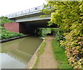
Hennef Way Bridge No 162
is a minor waterways place
on the Oxford Canal (Southern Section - Main Line) between
Concorde Avenue Bridge No 165 (6 furlongs
and 1 lock
to the south) and
Caves Bridge No 157 (2 miles and 3 furlongs
and 2 locks
to the northeast).
The nearest place in the direction of Concorde Avenue Bridge No 165 is Grimsbury Wharf;
½ furlongs
away.
The nearest place in the direction of Caves Bridge No 157 is Southam Road Winding Hole;
1 furlong
away.
Mooring here is unrated.
There is a bridge here which takes a dual carriageway over the canal.
Castle Quay Footbridge | 4½ furlongs | |
Tom Rolt Bridge No 164 | 4¼ furlongs | |
Sovereign Wharf | 3½ furlongs | |
Marsh Footbridge No 163 | 2 furlongs | |
Grimsbury Wharf | ½ furlongs | |
Hennef Way Bridge No 162 | ||
Southam Road Winding Hole | 1 furlong | |
Southam Road Footbridge No 161 | 3¼ furlongs | |
Southam Road Footbridge Arm | 3½ furlongs | |
Site of Old Bridge No 161 | 5½ furlongs | |
Banbury Railway Bridge No 161A | 7¼ furlongs |
- Oxford Canal Walk - Part One - Oxford to Thrupp - YouTube — associated with Oxford Canal
- A walk along the Oxford Canal (Southern Section) from Oxford to Thrupp Wide
Mouseover for more information or show routes to facility
Nearest water point
In the direction of Napton Junction
Cropredy Services — 3 miles, 6 furlongs and 3 locks away
On this waterway in the direction of Napton Junction
Cropredy Marina (southern basin) — 4 miles, 2¾ furlongs and 4 locks away
On this waterway in the direction of Napton Junction
Cropredy Marina (northern basins) — 4 miles, 3 furlongs and 4 locks away
On this waterway in the direction of Napton Junction
Fenny Compton Wharf — 10 miles, ½ furlongs and 12 locks away
On this waterway in the direction of Napton Junction
Marston Doles Water Point — 17 miles, 4¼ furlongs and 12 locks away
On this waterway in the direction of Napton Junction
Water Point at Bottom of Napton Locks — 19 miles, 4½ furlongs and 21 locks away
On this waterway in the direction of Napton Junction
In the direction of End of Hythe Bridge Arm
Sovereign Wharf — 3½ furlongs away
On this waterway in the direction of End of Hythe Bridge Arm
Banbury Lock No 29 — 5¾ furlongs away
On this waterway in the direction of End of Hythe Bridge Arm
Cherwell Street Facilities — 6 furlongs and 1 lock away
On this waterway in the direction of End of Hythe Bridge Arm
Aynho Wharf — 7 miles, 3¾ furlongs and 5 locks away
On this waterway in the direction of End of Hythe Bridge Arm
Heyford Wharf — 13 miles, 4 furlongs and 8 locks away
On this waterway in the direction of End of Hythe Bridge Arm
Heyford Wharf Bridge No 206 — 13 miles, 4¼ furlongs and 8 locks away
On this waterway in the direction of End of Hythe Bridge ArmNearest rubbish disposal
In the direction of Napton Junction
Cropredy Services — 3 miles, 6 furlongs and 3 locks away
On this waterway in the direction of Napton Junction
Cropredy Marina (southern basin) — 4 miles, 2¾ furlongs and 4 locks away
On this waterway in the direction of Napton Junction
Cropredy Marina (northern basins) — 4 miles, 3 furlongs and 4 locks away
On this waterway in the direction of Napton Junction
Fenny Compton Marina — 9 miles, 5¾ furlongs and 12 locks away
On this waterway in the direction of Napton Junction
Napton Sanitary Station — 19 miles, 4¼ furlongs and 21 locks away
On this waterway in the direction of Napton Junction
In the direction of End of Hythe Bridge Arm
Sovereign Wharf — 3½ furlongs away
On this waterway in the direction of End of Hythe Bridge Arm
Cherwell Street Facilities — 6 furlongs and 1 lock away
On this waterway in the direction of End of Hythe Bridge Arm
Aynho Wharf — 7 miles, 3¾ furlongs and 5 locks away
On this waterway in the direction of End of Hythe Bridge Arm
Heyford Wharf — 13 miles, 4 furlongs and 8 locks away
On this waterway in the direction of End of Hythe Bridge Arm
Heyford Wharf Bridge No 206 — 13 miles, 4¼ furlongs and 8 locks away
On this waterway in the direction of End of Hythe Bridge ArmNearest chemical toilet disposal
In the direction of Napton Junction
Cropredy Services — 3 miles, 6 furlongs and 3 locks away
On this waterway in the direction of Napton Junction
Cropredy Marina (southern basin) — 4 miles, 2¾ furlongs and 4 locks away
On this waterway in the direction of Napton Junction
Napton Sanitary Station — 19 miles, 4¼ furlongs and 21 locks away
On this waterway in the direction of Napton Junction
In the direction of End of Hythe Bridge Arm
Sovereign Wharf — 3½ furlongs away
On this waterway in the direction of End of Hythe Bridge Arm
Cherwell Street Facilities — 6 furlongs and 1 lock away
On this waterway in the direction of End of Hythe Bridge ArmNearest place to turn
In the direction of Napton Junction
Southam Road Winding Hole — 1 furlong away
On this waterway in the direction of Napton Junction
Southam Road Footbridge Arm — 3½ furlongs away
On this waterway in the direction of Napton Junction
Cropredy Services — 3 miles, 6 furlongs and 3 locks away
On this waterway in the direction of Napton Junction
Cropredy Marina (southern basin) — 4 miles, 2¾ furlongs and 4 locks away
On this waterway in the direction of Napton Junction
Cropredy Marina (northern basins) — 4 miles, 3 furlongs and 4 locks away
On this waterway in the direction of Napton Junction
Clattercote Bridge Winding Hole — 5 miles, 5¾ furlongs and 7 locks away
On this waterway in the direction of Napton Junction
Fenny Compton Marina — 9 miles, 5¾ furlongs and 12 locks away
On this waterway in the direction of Napton Junction
Fenny Compton Wharf — 10 miles, ½ furlongs and 12 locks away
On this waterway in the direction of Napton Junction
Marston Doles Top Lock Winding Hole — 17 miles, 4½ furlongs and 12 locks away
On this waterway in the direction of Napton Junction
In the direction of End of Hythe Bridge Arm
Grimsbury Wharf — ½ furlongs away
On this waterway in the direction of End of Hythe Bridge Arm
Calthorpe Winding Hole — 1 mile, 3½ furlongs and 1 lock away
On this waterway in the direction of End of Hythe Bridge Arm
Twyford Wharf Winding Hole — 3 miles, 4 furlongs and 2 locks away
On this waterway in the direction of End of Hythe Bridge Arm
Winding Hole above Nell Bridge Lock — 6 miles, 1 furlong and 3 locks away
On this waterway in the direction of End of Hythe Bridge Arm
Aynho Wharf — 7 miles, 3¾ furlongs and 5 locks away
On this waterway in the direction of End of Hythe Bridge Arm
Somerton Deep Lock Winding Hole — 9 miles, 1¾ furlongs and 5 locks away
On this waterway in the direction of End of Hythe Bridge Arm
Heyford Wharf Winding Hole — 13 miles, 3¾ furlongs and 8 locks away
On this waterway in the direction of End of Hythe Bridge Arm
Heyford Wharf — 13 miles, 4 furlongs and 8 locks away
On this waterway in the direction of End of Hythe Bridge Arm
The Cleeves Winding Hole — 13 miles, 7¾ furlongs and 8 locks away
On this waterway in the direction of End of Hythe Bridge Arm
Kirtlington Winding Hole — 16 miles, 6¼ furlongs and 10 locks away
On this waterway in the direction of End of Hythe Bridge Arm
Enslow Winding Hole — 18 miles, 3¾ furlongs and 11 locks away
On this waterway in the direction of End of Hythe Bridge ArmNearest self-operated pump-out
In the direction of Napton Junction
Cropredy Marina (southern basin) — 4 miles, 2¾ furlongs and 4 locks away
On this waterway in the direction of Napton JunctionNearest boatyard pump-out
In the direction of Napton Junction
Cropredy Marina (southern basin) — 4 miles, 2¾ furlongs and 4 locks away
On this waterway in the direction of Napton Junction
In the direction of End of Hythe Bridge Arm
Sovereign Wharf — 3½ furlongs away
On this waterway in the direction of End of Hythe Bridge Arm
Twyford Wharf — 3 miles, 4¼ furlongs and 2 locks away
On this waterway in the direction of End of Hythe Bridge Arm
Aynho Wharf — 7 miles, 3¾ furlongs and 5 locks away
On this waterway in the direction of End of Hythe Bridge Arm
Heyford Wharf — 13 miles, 4 furlongs and 8 locks away
On this waterway in the direction of End of Hythe Bridge Arm
Enslow Wharf — 18 miles, 5 furlongs and 11 locks away
On this waterway in the direction of End of Hythe Bridge ArmDirection of TV transmitter (From Wolfbane Cybernetic)
There is no page on Wikipedia called “Hennef Way Bridge”
Wikipedia pages that might relate to Hennef Way Bridge
[History of Banbury]
Archived from the original on 22 July 2011. Retrieved 19 July 2011. "Hennef Way bridge in Banbury:: OS grid SP4641 :: Geograph Britain and Ireland - photograph
[Banbury]
times. During excavations for the construction of an office building in Hennef Way in 2002, the remains of a British Iron Age settlement with circular buildings
[A361 road]
For about two miles the route is signed as A422, the dual carriageway Hennef Way until Junction 11 of the M40. From there it heads northeast through the
[Köln Hauptbahnhof]
Hauptbahnhof. The stations are linked by the Hohenzollern Bridge, a six-track railway bridge with pedestrian and bicycle lanes on each side. Frequent local
[Grimsbury]
modernised thereafter. Banbury Rural District built a reservoir near today's Hennef Way road circa the late 1960s. The 1960s industrial estates are home to both
[Timeline of the 2011 England riots]
three fires in Banbury, involving a burning car in Waterworks Road near Hennef Way, a fire in a skip to the rear of a house in Bretch Hill and the Pepper
[Ian Hamilton Finlay]
with Nicholas Sloan, Luton, England, Stockwood Park, 1991 tree-plaque, Hennef, Germany, private garden, 1991 Lübeck, Germany, Overbeck-Gesellschaft, 1991
[List of Statutory Instruments of the United Kingdom, 2001]
Trunk Road (Ryton-on-Dunsmore Roundabout to the A361 Southam Road/A422 Hennef Way Roundabout) (Detrunking) Order 2001 SI 2001/1518 The Armed Forces Act
[Cologne–Aachen high-speed railway]
operated to Düren, but since then line S 12 has run from Au (Sieg) via Hennef, Troisdorf and Cologne to Düren. Köln-Weiden West station, which serves
[Bundesstraße 8]
Brücke bridge in Regensburg (1135-46), the Innbrücke bridge in Passau (1143), the Lahnbrücke bridge in Limburg (completed 1341) and the main bridges in Würzburg
Results of Google Search
1Where a road has no road number (unclassified) a location is given ... South of Oxford Ring road ..... Magdalen Bridge, Oxford ..... South of Hennef Way (IRR).
A bridge to nowhere is a bridge where one or both ends are broken or incomplete and does not .... The Bridge to Nowhere, built in 1936, is an isolated 40-metre road bridge over the Mangapurua Stream in Whanganui National Park, North ...
Apr 10, 2017 ... number of overarching infrastructure issues facing. Oxfordshire including: .... Central Didcot Transport Corridor (Jubilee Way to Science Bridge).
Mar 31, 2017 ... (Published pursuant to Article 13 or Article 38 of Regulation (EC) No 726/2004 of the European Parliament and of ... 162 avenue Jean Jaurès, 69007 Lyon, France . EU/1/06/ ... bridge UB8 1DH, United Kingdom ... 6 Falcon Way, Shire Park, Welwyn Garden City, ... Josef-Dietzgen-Strasse 1, D-53773 Hennef,.
Kofax solutions have transformed the way we manage the new hire process. We' re not stuck in the past or buried in paper anymore; we have a slick mobile app ...
and Gulf coasts include but are not limited to American shad, river herring, Alabama ..... proximity or inclusion of bridges, buildings, or other structures, flow ..... attraction and guidance to fish on their way to the first fishway weir, vertical slot, or baffle. ...... 162. West Winterport Dam Removal. Marsh Stream, Winterport, Maine.
This is a human-readable summary of (and not a substitute for) the license. ... You may do so in any reasonable manner, but not in any way that suggests the ...
Situated in the heart of Europe, Germany has plenty of fantastic tourist attractions and unique sights to offer. Visitors from all over the world travel to Germany to ...
Downstream winding hole Just north of Basin Bridge 22, Basin Bridge Lane. Update 28-11-2018 ... roosts within the bridge arch and are hopeful this will not affect the timing of the works. Any changes ...... Bridge 162, Hennef Way. Downstream ...