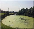
Swinton Junction
is a major waterways place
at the junction of
the Sheffield and South Yorkshire Navigation (Main Line)
with
the Sheffield and South Yorkshire Navigation (Dearne and Dove Canal).
Conisbrough Viaduct
is on
the Sheffield and South Yorkshire Navigation (Main Line),
4 miles and 3½ furlongs
and 3 locks
to the east.
Greasbrough Junction (Junction of the main line with the Greasbrough Canal )
is on
the Sheffield and South Yorkshire Navigation (Main Line),
4 miles and 6½ furlongs
and 3 locks
to the southwest.
Swinton Top Lock No 4
is on
the Sheffield and South Yorkshire Navigation (Dearne and Dove Canal),
4 furlongs
and 3 locks
to the northwest.
The nearest place in the direction of Conisbrough Viaduct is Swinton (Waddington) Lock No 8;
¼ furlongs
away.
The nearest place in the direction of Greasbrough Junction is Kilnhurst Burton Ings Bridge No 47;
1½ furlongs
away.
The nearest place in the direction of Swinton Top Lock No 4 is Swinton Bottom Lock No 1;
¾ furlongs
away.
Mooring here is unrated.
You can wind here.
Sheffield and South Yorkshire Navigation (Main Line) | ||
---|---|---|
Rowms Lane Railway Bridge | 3¾ furlongs | |
Rowms Lane Railway Bridge No 48A (disused) | 3½ furlongs | |
Swinton Talbot Road Bridge No 48 | 2 furlongs | |
Swinton Lock Activity Centre and CRT Sanitary Station | ¾ furlongs | |
Swinton (Waddington) Lock No 8 | ¼ furlongs | |
Swinton Junction | ||
Kilnhurst Burton Ings Bridge No 47 | 1½ furlongs | |
Kilnhurst Forge Flood Lock (disused) | 4¼ furlongs | |
Kilnhurst Moorings | 7¾ furlongs | |
Kilnhurst Station Road Bridge No 46 | 1 mile, ¼ furlongs | |
Glasshouse Lane Pipe Bridge | 1 mile, 2½ furlongs | |
Sheffield and South Yorkshire Navigation (Dearne and Dove Canal) | ||
Swinton Junction | ||
Swinton Bottom Lock No 1 | ¾ furlongs | |
Swinton Lock No 2 | 1¾ furlongs | |
Swinton Lock No 3 | 3 furlongs | |
Swinton Top Lock No 4 | 4 furlongs | |
Bridge Street Bridge (Swinton) | 4 furlongs |
- S&SY navigation info — associated with Sheffield and South Yorkshire Navigation
- Sheffield & South Yorkshire navigation info from IWA
Mouseover for more information or show routes to facility
Nearest water point
In the direction of Rawmarsh Road Bridge No 39
Kilnhurst Flood Lock No 7 — 1 mile, 4¾ furlongs away
On the Sheffield and South Yorkshire Navigation (Main Line) in the direction of Rawmarsh Road Bridge No 39
Eastwood Lock No 5 — 4 miles, 2¼ furlongs and 2 locks away
On the Sheffield and South Yorkshire Navigation (Main Line) in the direction of Rawmarsh Road Bridge No 39
Victoria Quays — 11 miles, 7¼ furlongs and 18 locks away
Travel to Rawmarsh Road Bridge No 39, then on the Sheffield and South Yorkshire Navigation (Sheffield Canal) to Victoria Quays
In the direction of Bramwith Junction
Swinton Lock Activity Centre and CRT Sanitary Station — ¾ furlongs and 1 lock away
On the Sheffield and South Yorkshire Navigation (Main Line) in the direction of Bramwith Junction
Mexborough Low Lock No 10 — 2 miles, 5½ furlongs and 2 locks away
On the Sheffield and South Yorkshire Navigation (Main Line) in the direction of Bramwith Junction
Sprotbrough Lock No 11 — 6 miles, 1 furlong and 3 locks away
On the Sheffield and South Yorkshire Navigation (Main Line) in the direction of Bramwith Junction
Doncaster Town Lock No 12 — 9 miles, 3¼ furlongs and 4 locks away
On the Sheffield and South Yorkshire Navigation (Main Line) in the direction of Bramwith Junction
Doncaster Visitor Pontoon Moorings — 9 miles, 5½ furlongs and 5 locks away
On the Sheffield and South Yorkshire Navigation (Main Line) in the direction of Bramwith Junction
Long Sandall Lock No 13 — 12 miles, 7 furlongs and 5 locks away
On the Sheffield and South Yorkshire Navigation (Main Line) in the direction of Bramwith Junction
Barnby Dun Lift Bridge — 15 miles, ¼ furlongs and 6 locks away
On the Sheffield and South Yorkshire Navigation (Main Line) in the direction of Bramwith Junction
Bramwith Lock No 14 — 16 miles, 3 furlongs and 6 locks away
Travel to Bramwith Junction, then on the Sheffield and South Yorkshire Navigation (Bramwith to Stainforth) to Bramwith Lock No 14
Bramwith Swing Bridge — 16 miles, 5¾ furlongs and 7 locks away
Travel to Bramwith Junction, then on the Sheffield and South Yorkshire Navigation (Bramwith to Stainforth) to Bramwith Swing BridgeNearest rubbish disposal
In the direction of Rawmarsh Road Bridge No 39
Eastwood Lock No 5 — 4 miles, 2¼ furlongs and 2 locks away
On the Sheffield and South Yorkshire Navigation (Main Line) in the direction of Rawmarsh Road Bridge No 39
Tinsley CRT facilities — 9 miles, 1½ furlongs and 17 locks away
Travel to Rawmarsh Road Bridge No 39, then on the Sheffield and South Yorkshire Navigation (Sheffield Canal) to Tinsley CRT facilities
Victoria Quays — 11 miles, 7¼ furlongs and 18 locks away
Travel to Rawmarsh Road Bridge No 39, then on the Sheffield and South Yorkshire Navigation (Sheffield Canal) to Victoria Quays
In the direction of Bramwith Junction
Doncaster Visitor Pontoon Moorings — 9 miles, 5½ furlongs and 5 locks away
On the Sheffield and South Yorkshire Navigation (Main Line) in the direction of Bramwith Junction
Barnby Dun Lift Bridge — 15 miles, ¼ furlongs and 6 locks away
On the Sheffield and South Yorkshire Navigation (Main Line) in the direction of Bramwith Junction
Bramwith Swing Bridge — 16 miles, 5¾ furlongs and 7 locks away
Travel to Bramwith Junction, then on the Sheffield and South Yorkshire Navigation (Bramwith to Stainforth) to Bramwith Swing BridgeNearest chemical toilet disposal
In the direction of Rawmarsh Road Bridge No 39
Eastwood Lock No 5 — 4 miles, 2¼ furlongs and 2 locks away
On the Sheffield and South Yorkshire Navigation (Main Line) in the direction of Rawmarsh Road Bridge No 39
Tinsley CRT facilities — 9 miles, 1½ furlongs and 17 locks away
Travel to Rawmarsh Road Bridge No 39, then on the Sheffield and South Yorkshire Navigation (Sheffield Canal) to Tinsley CRT facilities
Victoria Quays — 11 miles, 7¼ furlongs and 18 locks away
Travel to Rawmarsh Road Bridge No 39, then on the Sheffield and South Yorkshire Navigation (Sheffield Canal) to Victoria Quays
In the direction of Bramwith Junction
Swinton Lock Activity Centre and CRT Sanitary Station — ¾ furlongs and 1 lock away
On the Sheffield and South Yorkshire Navigation (Main Line) in the direction of Bramwith Junction
Barnby Dun Lift Bridge — 15 miles, ¼ furlongs and 6 locks away
On the Sheffield and South Yorkshire Navigation (Main Line) in the direction of Bramwith Junction
Bramwith Swing Bridge — 16 miles, 5¾ furlongs and 7 locks away
Travel to Bramwith Junction, then on the Sheffield and South Yorkshire Navigation (Bramwith to Stainforth) to Bramwith Swing BridgeNearest place to turn
In the direction of Rawmarsh Road Bridge No 39
Kilnhurst Flood Lock Winding Hole — 1 mile, 6½ furlongs and 1 lock away
On the Sheffield and South Yorkshire Navigation (Main Line) in the direction of Rawmarsh Road Bridge No 39
Sir Frank Price Lock Weir Exit — 4 miles, 1¾ furlongs and 2 locks away
On the Sheffield and South Yorkshire Navigation (Main Line) in the direction of Rawmarsh Road Bridge No 39
Sir Frank Price Lock Arm — 4 miles, 3 furlongs and 3 locks away
On the Sheffield and South Yorkshire Navigation (Main Line) in the direction of Rawmarsh Road Bridge No 39
Rawmarsh Road Winding Hole — 4 miles, 7¾ furlongs and 3 locks away
Travel to Rawmarsh Road Bridge No 39, then on the Sheffield and South Yorkshire Navigation (Sheffield Canal) to Rawmarsh Road Winding Hole
Central Road Winding Hole — 5 miles, 5½ furlongs and 3 locks away
Travel to Rawmarsh Road Bridge No 39, then on the Sheffield and South Yorkshire Navigation (Sheffield Canal) to Central Road Winding Hole
Main Street Junction — 5 miles, 6½ furlongs and 4 locks away
Travel to Rawmarsh Road Bridge No 39, then on the Sheffield and South Yorkshire Navigation (Sheffield Canal) to Main Street Junction
Rotherham Junction — 6 miles, ¼ furlongs and 4 locks away
Travel to Rawmarsh Road Bridge No 39, then on the Sheffield and South Yorkshire Navigation (Sheffield Canal) to Rotherham Junction
Tinsley Lower Flight Weir Exit — 8 miles, ¼ furlongs and 7 locks away
Travel to Rawmarsh Road Bridge No 39, then on the Sheffield and South Yorkshire Navigation (Sheffield Canal) to Tinsley Lower Flight Weir Exit
Don Valley Stadium Visitor Moorings — 10 miles, ¾ furlongs and 18 locks away
Travel to Rawmarsh Road Bridge No 39, then on the Sheffield and South Yorkshire Navigation (Sheffield Canal) to Don Valley Stadium Visitor Moorings
Shirland Road Bridge Winding Hole — 10 miles, 3¼ furlongs and 18 locks away
Travel to Rawmarsh Road Bridge No 39, then on the Sheffield and South Yorkshire Navigation (Sheffield Canal) to Shirland Road Bridge Winding Hole
Victoria Quays — 11 miles, 7¼ furlongs and 18 locks away
Travel to Rawmarsh Road Bridge No 39, then on the Sheffield and South Yorkshire Navigation (Sheffield Canal) to Victoria Quays
Sheffield Terminal Warehouse — 11 miles, 7½ furlongs and 18 locks away
Travel to Rawmarsh Road Bridge No 39, then on the Sheffield and South Yorkshire Navigation (Sheffield Canal) to Sheffield Terminal Warehouse
In the direction of Bramwith Junction
Swinton Road Corner — 4 furlongs and 1 lock away
On the Sheffield and South Yorkshire Navigation (Main Line) in the direction of Bramwith Junction
Sprotbrough Lock Weir Exit — 6 miles, 1½ furlongs and 4 locks away
On the Sheffield and South Yorkshire Navigation (Main Line) in the direction of Bramwith Junction
Doncaster Visitor Pontoon Moorings — 9 miles, 5½ furlongs and 5 locks away
On the Sheffield and South Yorkshire Navigation (Main Line) in the direction of Bramwith Junction
Gas House Bight — 9 miles, 7 furlongs and 5 locks away
On the Sheffield and South Yorkshire Navigation (Main Line) in the direction of Bramwith Junction
Wheatley Hall Road Winding Hole — 11 miles, 6¼ furlongs and 5 locks away
On the Sheffield and South Yorkshire Navigation (Main Line) in the direction of Bramwith Junction
Huddle Grounds Winding Hole — 18 miles, 5 furlongs and 7 locks away
Travel to Bramwith Junction, then on the Sheffield and South Yorkshire Navigation (Bramwith to Stainforth) to Stainforth Junction, then on the Sheffield and South Yorkshire Navigation (Stainforth and Keadby Canal) to Huddle Grounds Winding HoleNearest self-operated pump-out
In the direction of Bramwith Junction
Long Sandall Lock No 13 — 12 miles, 7 furlongs and 5 locks away
On the Sheffield and South Yorkshire Navigation (Main Line) in the direction of Bramwith JunctionNo information
CanalPlan has no information on any of the following facilities within range:boatyard pump-out
Direction of TV transmitter (From Wolfbane Cybernetic)
There is no page on Wikipedia called “Swinton Junction”
Wikipedia pages that might relate to Swinton Junction
[Swinton–Doncaster line]
The Swinton–Doncaster line is a short railway line in South Yorkshire between Swinton Junction on the Wakefield Line and Doncaster South Yorkshire Junction
[Swinton, Greater Manchester]
Swinton is a town within the City of Salford in Greater Manchester, England, southwest of the River Irwell, 3.4 miles (5.5 km) northwest of Salford and
[Wakefield line]
Moorthorpe–Swinton Swinton & Knottingley Joint Railway itself being of joint Midland Railway (MidR) and North Eastern Railway (NER) ownership. Swinton–Sheffield
[Aldwarke Junction]
the third and fourth running lines north of the junction as far as Swinton junction and remodel Swinton station to increase capacity. These plans were
[Swinton railway station (South Yorkshire)]
Swinton railway station is a railway station in Swinton, South Yorkshire, England. It has three platforms and a small bus station, and lies at the junction
[Midland Main Line]
Masborough, Swinton and Normanton. On 10 May 1844 the North Midland Railway, the Midland Counties Railway and the Birmingham and Derby Junction Railway merged
[Municipal Borough of Swinton and Pendlebury]
opened within the newly built Lancastrian Hall on Chorley Road, Swinton at the junction with Station Road (B5231). It was created as an urban district
[Pendlebury]
link between Swinton (A6) and Pendlebury (A666). The remaining section of Swinton Hall Road, between the Swinton parish boundary (near junction with Temple
[Swinton railway station (Greater Manchester)]
Pendlebury and not Swinton itself, the boundary between the two districts being about 40 yards further down Station Road (B5231), beyond the junction with Boundary
[North Midland Railway]
from Swinton (Wath Road Junction) to Normanton (Goose Hill Junction), although it was still heavily used by freight. By May 1972 however the Swinton and
Results of Google Search
Swinton–Doncaster line - WikipediaThe Swinton–Doncaster line is a short railway line in South Yorkshire between Swinton Junction on the Wakefield Line and Doncaster South Yorkshire Junction  ...
Waddington's_boatyard_Swinton_junction_-_geograph.org.uk_-_590266.jpg #x200e;( 640 × 527 pixels, file size: 135 KB, MIME type: image/jpeg) ...
Swinton railway station is a railway station in Swinton, South Yorkshire, England. It has three platforms and a small bus station, and lies at the junction of the ...
See departure times for every stop on this bus route. Major stops include: Clifton Junction - Swinton - Worsley - Eccles.
30 Jul 2019- Junction of Chorley Road and Station Road, Swinton.
Aug 22, 2019 ... The Roydon Group has bought a 126000 sq ft unit at Junction Eco Business Park in Swinton, UK.
Both images scanned from a book I own called "Manchester in the '70s". This is what Hulme used to look like when these flats were built in the 1960s, the one ...
3 days ago ... Eccles New Road, Salford at the junction with Howard Street. ... A6 Chorley Road , Swinton at the junctions of Station Road and Partington Lane ...
Swinton Market Place c1960's Junction of Worsley Road, Chorley Road and Manchester Road.
Apr 3, 2019 ... Highways bosses stopped all traffic clockwise from junction 12, for Eccles Interchange, to junction 13, for Swinton.