Torksey Lock
is a minor waterways place
on the Fossdyke Canal between
Saxilby Bridge (5 miles and 1¼ furlongs
to the east) and
Torksey Junction (Junction of Fossdyke Canal with River Trent.) (2 furlongs
to the west).
The nearest place in the direction of Saxilby Bridge is Torksey Lock Visitor Moorings (Fossdyke);
2¼ furlongs
away.
The nearest place in the direction of Torksey Junction is A156 Road Bridge (Road runs over the lock);
¼ furlongs
away.
There is access (suitable for wheels) to the towpath here.
Mooring here is impossible (it may be physically impossible, forbidden, or allowed only for specific short-term purposes).
Facilities: chemical toilet disposal, boater-operated pump-out, rubbish disposal, showers, toilets, water point, paper recycling, tin can recycling and aluminium can recycling.
There is a bridge here which takes pedestrian traffic over the canal.
This is a lock, the rise of which is not known.
Saxilby Village Wharf Visitor Moorings | 4 miles, 7¾ furlongs | |
West Bank Railway Bridge | 4 miles, 7¼ furlongs | |
Drinsey Nook | 3 miles, 4¼ furlongs | |
Hardwick | 2 miles, 6 furlongs | |
Torksey Lock Visitor Moorings (Fossdyke) | 2¼ furlongs | |
Torksey Lock | ||
A156 Road Bridge | ¼ furlongs | |
Torksey Lock Visitor Moorings (Trent) | 1½ furlongs | |
Torksey Junction | 2 furlongs |
Amenities here
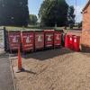
Garbage and recycling is in the north carpark, so walk over the lock passed the plum tree.
Pumpout available during lockeepers hours.
There are no links to external websites from here.
Why not log in and add some (select "External websites" from the menu (sometimes this is under "Edit"))?
Mouseover for more information or show routes to facility
Nearest water point
The nearest water point is here. Others are at:
In the direction of Torksey Junction
West Stockwith Basin — 15 miles, 1 furlong and 2 locks away
Travel to Torksey Junction, then on the River Trent (tidal section - Cromwell to Keadby) to Chesterfield Canal - River Trent Junction, then on the Chesterfield Canal (Retford to the Trent) to West Stockwith Basin
Cromwell Lock Weir Entrance — 16 miles, 4¾ furlongs and 2 locks away
Travel to Torksey Junction, then on the River Trent (tidal section - Cromwell to Keadby) to Cromwell Lock Weir Exit, then on the River Trent (non-tidal section) to Cromwell Lock Weir Entrance
Cromwell Lock Visitor Mooring Pontoon — 16 miles, 5¼ furlongs and 2 locks away
Travel to Torksey Junction, then on the River Trent (tidal section - Cromwell to Keadby) to Cromwell Lock Weir Exit, then on the River Trent (non-tidal section) to Cromwell Lock Visitor Mooring Pontoon
In the direction of High Bridge Lincoln (the Glory Hole)
Saxilby Village Water Point — 5 miles, ½ furlongs and 1 lock away
On this waterway in the direction of High Bridge Lincoln (the Glory Hole)
Lincoln Boaters Facilities — 10 miles, 2¼ furlongs and 1 lock away
On this waterway in the direction of High Bridge Lincoln (the Glory Hole)
Stamp End Lock No 1 — 11 miles, 3½ furlongs and 1 lock away
Travel to High Bridge Lincoln (the Glory Hole), then on the River Witham (Lincoln to Boston) to Stamp End Lock No 1
Bardney Lock No 2 — 19 miles, ¾ furlongs and 2 locks away
Travel to High Bridge Lincoln (the Glory Hole), then on the River Witham (Lincoln to Boston) to Bardney Lock No 2Nearest rubbish disposal
The nearest rubbish disposal is here. Others are at:
In the direction of Torksey Junction
West Stockwith Basin — 15 miles, 1 furlong and 2 locks away
Travel to Torksey Junction, then on the River Trent (tidal section - Cromwell to Keadby) to Chesterfield Canal - River Trent Junction, then on the Chesterfield Canal (Retford to the Trent) to West Stockwith Basin
Cromwell Lock No 11 — 16 miles, 3¾ furlongs and 1 lock away
Travel to Torksey Junction, then on the River Trent (tidal section - Cromwell to Keadby) to Cromwell Lock Weir Exit, then on the River Trent (non-tidal section) to Cromwell Lock No 11
In the direction of High Bridge Lincoln (the Glory Hole)
Lincoln Boaters Facilities — 10 miles, 2¼ furlongs and 1 lock away
On this waterway in the direction of High Bridge Lincoln (the Glory Hole)
Bardney Lock No 2 — 19 miles, ¾ furlongs and 2 locks away
Travel to High Bridge Lincoln (the Glory Hole), then on the River Witham (Lincoln to Boston) to Bardney Lock No 2Nearest chemical toilet disposal
The nearest chemical toilet disposal is here. Others are at:
In the direction of Torksey Junction
West Stockwith Basin — 15 miles, 1 furlong and 2 locks away
Travel to Torksey Junction, then on the River Trent (tidal section - Cromwell to Keadby) to Chesterfield Canal - River Trent Junction, then on the Chesterfield Canal (Retford to the Trent) to West Stockwith Basin
Cromwell Lock No 11 — 16 miles, 3¾ furlongs and 1 lock away
Travel to Torksey Junction, then on the River Trent (tidal section - Cromwell to Keadby) to Cromwell Lock Weir Exit, then on the River Trent (non-tidal section) to Cromwell Lock No 11
In the direction of High Bridge Lincoln (the Glory Hole)
Saxilby Council Public Facilities — 5 miles, ¼ furlongs and 1 lock away
On this waterway in the direction of High Bridge Lincoln (the Glory Hole)
Lincoln Boaters Facilities — 10 miles, 2¼ furlongs and 1 lock away
On this waterway in the direction of High Bridge Lincoln (the Glory Hole)
Bardney Lock No 2 — 19 miles, ¾ furlongs and 2 locks away
Travel to High Bridge Lincoln (the Glory Hole), then on the River Witham (Lincoln to Boston) to Bardney Lock No 2Nearest place to turn
In the direction of Torksey Junction
West Stockwith Basin — 15 miles, 1 furlong and 2 locks away
Travel to Torksey Junction, then on the River Trent (tidal section - Cromwell to Keadby) to Chesterfield Canal - River Trent Junction, then on the Chesterfield Canal (Retford to the Trent) to West Stockwith Basin
Cromwell Lock Weir Entrance — 16 miles, 4¾ furlongs and 2 locks away
Travel to Torksey Junction, then on the River Trent (tidal section - Cromwell to Keadby) to Cromwell Lock Weir Exit, then on the River Trent (non-tidal section) to Cromwell Lock Weir Entrance
Cromwell Lock Visitor Mooring Pontoon — 16 miles, 5¼ furlongs and 2 locks away
Travel to Torksey Junction, then on the River Trent (tidal section - Cromwell to Keadby) to Cromwell Lock Weir Exit, then on the River Trent (non-tidal section) to Cromwell Lock Visitor Mooring Pontoon
The Muskham Ferry — 17 miles, 6¾ furlongs and 2 locks away
Travel to Torksey Junction, then on the River Trent (tidal section - Cromwell to Keadby) to Cromwell Lock Weir Exit, then on the River Trent (non-tidal section) to The Muskham Ferry
Manor Farm Winding Hole — 17 miles, 5¼ furlongs and 4 locks away
Travel to Torksey Junction, then on the River Trent (tidal section - Cromwell to Keadby) to Chesterfield Canal - River Trent Junction, then on the Chesterfield Canal (Retford to the Trent) to Manor Farm Winding Hole
In the direction of High Bridge Lincoln (the Glory Hole)
Lincoln Boaters Facilities — 10 miles, 2¼ furlongs and 1 lock away
On this waterway in the direction of High Bridge Lincoln (the Glory Hole)
Bardney Village Visitor Moorings — 19 miles, 6 furlongs and 3 locks away
Travel to High Bridge Lincoln (the Glory Hole), then on the River Witham (Lincoln to Boston) to Bardney Village Visitor MooringsNearest self-operated pump-out
The nearest self-operated pump-out is here. Others are at:
In the direction of High Bridge Lincoln (the Glory Hole)
Lincoln Boaters Facilities — 10 miles, 2¼ furlongs and 1 lock away
On this waterway in the direction of High Bridge Lincoln (the Glory Hole)No information
CanalPlan has no information on any of the following facilities within range:boatyard pump-out
Direction of TV transmitter (From Wolfbane Cybernetic)
The Tidal Trent - it's a bit of a bore from Scribblings from the Mintball posted Saturday the 2nd of August, 2014
What did the Romans ever do for us? from Scribblings from the Mintball posted Thursday the 31st of July, 2014
There is no page on Wikipedia called “Torksey Lock”
Wikipedia pages that might relate to Torksey Lock
[Torksey]
River Trent by way of a series of lock-gates about half a mile (800 m) south of the village. During the 9th century, Torksey was part of the Anglo-Saxon Kingdom
[Foss Dyke]
James I. Improvements made in 1671 included a navigable sluice or lock at Torksey, and warehousing and wharves were built at Brayford Pool in the centre
[River Trent]
Trent. Downstream of Dunham the river passes Church Laneham and reaches Torksey, where it meets the Foss Dyke navigation which connects the Trent to Lincoln
[Clapper gates]
"Riverside gate description". geograph.co.uk. Retrieved 10 May 2013. "Torksey-Lock-Trail" (PDF). canalrivertrust.org.uk. Archived from the original (PDF)
[A156 road]
single carriageway for its entire length apart from one small stretch at Torksey Lock where the A1133 joins from Newark-on-Trent. The road starts just west
[List of bridges and viaducts in Lincolnshire]
England. Bridges are listed under their current use or traffic. For example, Torksey Viaduct is listed under 'Highway' as it is now used by foot and cycle traffic
[Upper Witham IDB]
which the five major 'gaps' along the Trent, at Spalford, Newton, Torksey Lock, Torksey and Marton, were extensively repaired by the Courts of Sewers for
[Fenton, West Lindsey]
Research-lincs.org.uk. 2005. Retrieved 9 April 2013. "Welcome to Fenton and Torksey Lock Parish Council's website". Lincolnshire.gov.uk. Retrieved 9 April 2013
[Barlings Eau]
extra water is delivered to the Witham by Trent pumping station, near Torksey Lock. This pumps water through a short pipeline and into the Foss Dyke. It
[Cromwell, Nottinghamshire]
lock commercial traffic and pleasure craft may navigate north towards Torksey Gainsborough and ultimately the Trent Falls where the River Trent meets
Results of Google Search
Torksey Lock | Places to visit | Canal & River TrustBefore the railways were built, ships sailed inland as far as Shardlow. Torksey Lock was the scene of much activity as ships and shallow bottomed barges called ...
Oct 26, 2016 ... Divers have carried out important repairs at historic Torksey Lock on the Fossdyke Navigation.
Torksey Lock. 21 Reviews. #1 of 1 things to do in Torksey · Other Outdoor Activities. Sorry, there are no tours or activities available to book online for the date(s) ...
Jan 16, 2018 ... In this part we take on the eerily calm (and bloody cold) tidal River Trent, setting off from Keadby Lock. All filmed on an iPhone 8+, edited using ...
Torksey is a small village in the West Lindsey district of Lincolnshire, England. The population ... Torksey Lock slipway. Torksey is located in Lincolnshire. Torksey. Location within Lincolnshire. Population, 875 (2011 census). OS grid reference ...
Torksey Lock Fisherman's Route is a 1.8 mile loop trail located near Lincoln, Lincolnshire, England that features a river and is good for all skill levels. The trail ...
Find properties to buy in Torksey Lock with the UK's largest data-driven property portal. View our wide selection of houses and flats for sale in Torksey Lock.
Torksey Lock Fisherman's Route is a 1.8 mile loop trail located near Lincoln, Lincolnshire, England that features a river and is good for all skill...
SK 87 NW TORKSEY FOSS DIKE SIDE 2/75 Torksey Lock and Footbridge II Canal lock and bridge. C19. Ashlar, wood, cast iron. Rectangular lock chamber with ...
Torksey Car Boot & Market - A156 Lincoln Rd, Torksey Lock, LN1 2EL Lincoln, Lincolnshire - Rated 4 based on 17 Reviews "By far the best car boot around,...