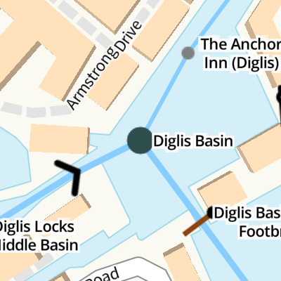
Diglis Basin
is a major waterways place
at the junction of
the Worcester and Birmingham Canal (Diglis Basin to King's Norton Junction)
with
the Worcester and Birmingham Canal (Diglis Junction to Diglis Basin)
and
the Worcester and Birmingham Canal (Diglis Basin Marina Arm).
Hanbury Junction (Junction with Droitwich Junction Canal (Restored - Opened 1/July/2011). Hanbury Wharf)
is on
the Worcester and Birmingham Canal (Diglis Basin to King's Norton Junction),
9 miles and ½ furlongs
and 14 locks
to the northeast.
Diglis Lock No 2
is on
the Worcester and Birmingham Canal (Diglis Junction to Diglis Basin),
¼ furlongs
to the west.
Diglis Basin Marina
is on
the Worcester and Birmingham Canal (Diglis Basin Marina Arm),
½ furlongs
to the southeast.
The nearest place in the direction of Hanbury Junction is The Anchor Inn (Diglis) (Canalside);
¼ furlongs
away.
The nearest place in the direction of Diglis Basin Marina is Diglis Basin Swing Footbridge;
¼ furlongs
away.
Mooring here is impossible (it may be physically impossible, forbidden, or allowed only for specific short-term purposes).
Facilities: rubbish disposal.
Worcester and Birmingham Canal (Diglis Basin to King's Norton Junction) | ||
---|---|---|
Diglis Basin | ||
The Anchor Inn (Diglis) | ¼ furlongs | |
Diglis Services | ½ furlongs | |
Mill Street Bridge No 2 | 1¼ furlongs | |
Diglis Visitor Moorings (Bath Road) | 1¾ furlongs | |
Sidbury Bridge No 3 | 2½ furlongs | |
Worcester and Birmingham Canal (Diglis Junction to Diglis Basin) | ||
Diglis Basin | ||
Diglis Lock No 2 | ¼ furlongs | |
Diglis Locks Middle Basin | ½ furlongs | |
Diglis Bottom Lock No 1 | ¾ furlongs | |
Diglis Bottom Swing Bridge No 1 | ¾ furlongs | |
Diglis Junction | 1¼ furlongs | |
Worcester and Birmingham Canal (Diglis Basin Marina Arm) | ||
Diglis Basin | ||
Diglis Basin Swing Footbridge | ¼ furlongs | |
Diglis Basin Marina | ½ furlongs |
Amenities in Worcester
Amenities at other places in Worcester
at
at
at
at
at
at
at
at
at
at
at
at
at
at
at
at
at
at
at
at
at
at
at
at
at
at
at
at
at
at
at
at
at
at
at
at
at
at
at
at
at
at
at
at
at
at
at
at
at
at
at
at
at
at
at
at
at
at
at
at
at
at
at
at
at
at
at
at
at
at
- Visit Diglis Basin and Dock - Discover its history — associated with this page
- Find out the best way to visit Diglis Basin and Dock in Worcester, how long it takes to see, and detailed info on its history.
Mouseover for more information or show routes to facility
Nearest water point
In the direction of King's Norton Junction
Diglis Services — ½ furlongs away
On the Worcester and Birmingham Canal (Diglis Basin to King's Norton Junction) in the direction of King's Norton Junction
Lowesmoor Basin — 1 mile, ¼ furlongs and 2 locks away
On the Worcester and Birmingham Canal (Diglis Basin to King's Norton Junction) in the direction of King's Norton Junction
Hanbury Boatyard — 8 miles, 7½ furlongs and 14 locks away
On the Worcester and Birmingham Canal (Diglis Basin to King's Norton Junction) in the direction of King's Norton Junction
Droitwich Spa Marina — 9 miles, 3¾ furlongs and 17 locks away
Travel to Hanbury Junction, then on the Droitwich Canals (Droitwich Junction Canal) to Droitwich Spa Marina
Stoke Works Water Point — 11 miles, 4¾ furlongs and 20 locks away
On the Worcester and Birmingham Canal (Diglis Basin to King's Norton Junction) in the direction of King's Norton Junction
Tardebigge Wharf — 15 miles, 5 furlongs and 56 locks away
On the Worcester and Birmingham Canal (Diglis Basin to King's Norton Junction) in the direction of King's Norton Junction
In the direction of Diglis Junction
Diglis Locks — 3½ furlongs and 2 locks away
Travel to Diglis Junction, then on the River Severn (main river - Worcester to Gloucester) to Diglis Locks
Worcester Trip Boat Moorings — 7¼ furlongs and 2 locks away
Travel to Diglis Junction, then on the River Severn (main river - Stourport to Worcester) to Worcester Trip Boat Moorings
Holt Lock (Holt Fleet) — 7 miles, 4 furlongs and 3 locks away
Travel to Diglis Junction, then on the River Severn (main river - Stourport to Worcester) to Holt Lock (Holt Fleet)
Lincomb Lock — 11 miles, 5¾ furlongs and 4 locks away
Travel to Diglis Junction, then on the River Severn (main river - Stourport to Worcester) to Lincomb Lock
Upper Basin Waterpoint — 13 miles, 1¼ furlongs and 7 locks away
Travel to Diglis Junction, then on the River Severn (main river - Stourport to Worcester) to Severn - Stourport Broad Locks Entrance, then on the Staffordshire and Worcestershire Canal (Stourport Basins: Broad Route) to Stourport Upper Basin, then on the Staffordshire and Worcestershire Canal (Stourport Basins: Narrow Route) to Upper Basin Waterpoint
Upper Lode Lock No 5 — 16 miles, 5¼ furlongs and 3 locks away
Travel to Diglis Junction, then on the River Severn (main river - Worcester to Gloucester) to Upper Lode Lock No 5
Tewkesbury Services — 16 miles, 3 furlongs and 4 locks away
Travel to Diglis Junction, then on the River Severn (main river - Worcester to Gloucester) to Tewkesbury Junction, then on the River Avon - Warwickshire (Lower Avon Navigation) to Tewkesbury Services
Netherwich Basin — 10 miles and 11 locks away
Travel to Diglis Junction, then on the River Severn (main river - Stourport to Worcester) to Hawford Junction, then on the Droitwich Canals (Droitwich Barge Canal) to Netherwich Basin
Tewkesbury Lower Lode — 17 miles, 3½ furlongs and 4 locks away
Travel to Diglis Junction, then on the River Severn (main river - Worcester to Gloucester) to Tewkesbury Lower Lode
Bredon — 19 miles, 6¾ furlongs and 4 locks away
Travel to Diglis Junction, then on the River Severn (main river - Worcester to Gloucester) to Tewkesbury Junction, then on the River Avon - Warwickshire (Lower Avon Navigation) to Bredon
Caldwall Mill Bridge No 14 — 16 miles, 7½ furlongs and 10 locks away
Travel to Diglis Junction, then on the River Severn (main river - Stourport to Worcester) to Severn - Stourport Broad Locks Entrance, then on the Staffordshire and Worcestershire Canal (Stourport Basins: Broad Route) to Stourport Upper Basin, then on the Staffordshire and Worcestershire Canal (Stourport Basins: Narrow Route) to York Street Bridge, then on the Staffordshire and Worcestershire Canal (Main Line: Stourport to Stourton) to Caldwall Mill Bridge No 14Nearest rubbish disposal
The nearest rubbish disposal is here. Others are at:
In the direction of King's Norton Junction
Lowesmoor Basin — 1 mile, ¼ furlongs and 2 locks away
On the Worcester and Birmingham Canal (Diglis Basin to King's Norton Junction) in the direction of King's Norton Junction
Droitwich Spa Marina — 9 miles, 3¾ furlongs and 17 locks away
Travel to Hanbury Junction, then on the Droitwich Canals (Droitwich Junction Canal) to Droitwich Spa Marina
Stoke Bottom Lock No 23 — 12 miles, 2½ furlongs and 20 locks away
On the Worcester and Birmingham Canal (Diglis Basin to King's Norton Junction) in the direction of King's Norton Junction
Tardebigge Wharf — 15 miles, 5 furlongs and 56 locks away
On the Worcester and Birmingham Canal (Diglis Basin to King's Norton Junction) in the direction of King's Norton Junction
In the direction of Diglis Junction
Sabrina Footbridge — 1 mile, 1 furlong and 2 locks away
Travel to Diglis Junction, then on the River Severn (main river - Stourport to Worcester) to Sabrina Footbridge
Upper Basin Waterpoint — 13 miles, 1¼ furlongs and 7 locks away
Travel to Diglis Junction, then on the River Severn (main river - Stourport to Worcester) to Severn - Stourport Broad Locks Entrance, then on the Staffordshire and Worcestershire Canal (Stourport Basins: Broad Route) to Stourport Upper Basin, then on the Staffordshire and Worcestershire Canal (Stourport Basins: Narrow Route) to Upper Basin Waterpoint
Tewkesbury Services — 16 miles, 3 furlongs and 4 locks away
Travel to Diglis Junction, then on the River Severn (main river - Worcester to Gloucester) to Tewkesbury Junction, then on the River Avon - Warwickshire (Lower Avon Navigation) to Tewkesbury Services
Netherwich Basin — 10 miles and 11 locks away
Travel to Diglis Junction, then on the River Severn (main river - Stourport to Worcester) to Hawford Junction, then on the Droitwich Canals (Droitwich Barge Canal) to Netherwich BasinNearest chemical toilet disposal
In the direction of King's Norton Junction
Diglis Services — ½ furlongs away
On the Worcester and Birmingham Canal (Diglis Basin to King's Norton Junction) in the direction of King's Norton Junction
Lowesmoor Basin — 1 mile, ¼ furlongs and 2 locks away
On the Worcester and Birmingham Canal (Diglis Basin to King's Norton Junction) in the direction of King's Norton Junction
Droitwich Spa Marina — 9 miles, 3¾ furlongs and 17 locks away
Travel to Hanbury Junction, then on the Droitwich Canals (Droitwich Junction Canal) to Droitwich Spa Marina
Stoke Bottom Lock No 23 — 12 miles, 2½ furlongs and 20 locks away
On the Worcester and Birmingham Canal (Diglis Basin to King's Norton Junction) in the direction of King's Norton Junction
Tardebigge Wharf — 15 miles, 5 furlongs and 56 locks away
On the Worcester and Birmingham Canal (Diglis Basin to King's Norton Junction) in the direction of King's Norton Junction
In the direction of Diglis Junction
Stourport Marina — 12 miles, 1 furlong and 5 locks away
Travel to Diglis Junction, then on the River Severn (main river - Stourport to Worcester) to Stourport Marina
Upper Basin Waterpoint — 13 miles, 1¼ furlongs and 7 locks away
Travel to Diglis Junction, then on the River Severn (main river - Stourport to Worcester) to Severn - Stourport Broad Locks Entrance, then on the Staffordshire and Worcestershire Canal (Stourport Basins: Broad Route) to Stourport Upper Basin, then on the Staffordshire and Worcestershire Canal (Stourport Basins: Narrow Route) to Upper Basin Waterpoint
Caldwall Mill Bridge No 14 — 16 miles, 7½ furlongs and 10 locks away
Travel to Diglis Junction, then on the River Severn (main river - Stourport to Worcester) to Severn - Stourport Broad Locks Entrance, then on the Staffordshire and Worcestershire Canal (Stourport Basins: Broad Route) to Stourport Upper Basin, then on the Staffordshire and Worcestershire Canal (Stourport Basins: Narrow Route) to York Street Bridge, then on the Staffordshire and Worcestershire Canal (Main Line: Stourport to Stourton) to Caldwall Mill Bridge No 14Nearest place to turn
In the direction of King's Norton Junction
Lowesmoor Basin — 1 mile, ¼ furlongs and 2 locks away
On the Worcester and Birmingham Canal (Diglis Basin to King's Norton Junction) in the direction of King's Norton Junction
Bilford Locks Winding Hole — 2 miles, 2 furlongs and 5 locks away
On the Worcester and Birmingham Canal (Diglis Basin to King's Norton Junction) in the direction of King's Norton Junction
Tibberton Winding Hole — 5 miles, 7½ furlongs and 14 locks away
On the Worcester and Birmingham Canal (Diglis Basin to King's Norton Junction) in the direction of King's Norton Junction
Dunhampstead Winding Hole — 6 miles, 7 furlongs and 14 locks away
On the Worcester and Birmingham Canal (Diglis Basin to King's Norton Junction) in the direction of King's Norton Junction
In the direction of Diglis Junction
Diglis Junction — 1¼ furlongs and 2 locks away
On the Worcester and Birmingham Canal (Diglis Junction to Diglis Basin) in the direction of Diglis Junction
Diglis Locks Weir Exit — 4¼ furlongs and 3 locks away
Travel to Diglis Junction, then on the River Severn (main river - Worcester to Gloucester) to Diglis Locks Weir Exit
Severn - Teme Junction — 1 mile, 2¼ furlongs and 3 locks away
Travel to Diglis Junction, then on the River Severn (main river - Worcester to Gloucester) to Severn - Teme Junction
Bevere Lock Weir Exit — 3 miles, 7¾ furlongs and 2 locks away
Travel to Diglis Junction, then on the River Severn (main river - Stourport to Worcester) to Bevere Lock Weir Exit
Bevere Lock Weir Entrance — 4 miles, 2¼ furlongs and 3 locks away
Travel to Diglis Junction, then on the River Severn (main river - Stourport to Worcester) to Bevere Lock Weir Entrance
Holt Lock Weir Exit — 7 miles, 3 furlongs and 3 locks away
Travel to Diglis Junction, then on the River Severn (main river - Stourport to Worcester) to Holt Lock Weir Exit
Holt Lock Weir Entrance — 7 miles, 6¼ furlongs and 4 locks away
Travel to Diglis Junction, then on the River Severn (main river - Stourport to Worcester) to Holt Lock Weir Entrance
Ladywood Top Lock Winding Hole — 7 miles, 2 furlongs and 11 locks away
Travel to Diglis Junction, then on the River Severn (main river - Stourport to Worcester) to Hawford Junction, then on the Droitwich Canals (Droitwich Barge Canal) to Ladywood Top Lock Winding Hole
Severn - Stourport Narrow Locks Entrance — 13 miles, ¼ furlongs and 5 locks away
Travel to Diglis Junction, then on the River Severn (main river - Stourport to Worcester) to Severn - Stourport Narrow Locks Entrance
Stourport Lower Basin - between Broad Locks — 13 miles, ¼ furlongs and 6 locks away
Travel to Diglis Junction, then on the River Severn (main river - Stourport to Worcester) to Severn - Stourport Broad Locks Entrance, then on the Staffordshire and Worcestershire Canal (Stourport Basins: Broad Route) to Stourport Lower Basin - between Broad Locks
Stourport Lower Basin - between Narrow Locks — 13 miles, ¾ furlongs and 6 locks away
Travel to Diglis Junction, then on the River Severn (main river - Stourport to Worcester) to Severn - Stourport Broad Locks Entrance, then on the Staffordshire and Worcestershire Canal (Stourport Basins: Broad Route) to Stourport Lower Basin - between Broad Locks, then on the Staffordshire and Worcestershire Canal (Stourport Basins: Broad Locks to Narrow Locks to Stourport Lower Basin - between Narrow Locks
Upper Lode Lock Weir Entrance — 16 miles, 4½ furlongs and 3 locks away
Travel to Diglis Junction, then on the River Severn (main river - Worcester to Gloucester) to Upper Lode Lock Weir Entrance
Stourport Upper Basin — 13 miles, 1 furlong and 7 locks away
Travel to Diglis Junction, then on the River Severn (main river - Stourport to Worcester) to Severn - Stourport Broad Locks Entrance, then on the Staffordshire and Worcestershire Canal (Stourport Basins: Broad Route) to Stourport Upper Basin
Stourport Clock Basin — 13 miles, 1½ furlongs and 7 locks away
Travel to Diglis Junction, then on the River Severn (main river - Stourport to Worcester) to Severn - Stourport Broad Locks Entrance, then on the Staffordshire and Worcestershire Canal (Stourport Basins: Broad Route) to Stourport Upper Basin, then on the Staffordshire and Worcestershire Canal (Stourport Basins: Narrow Route) to Stourport Clock Basin
Avon Lock Junction — 16 miles, 2¾ furlongs and 4 locks away
Travel to Diglis Junction, then on the River Severn (main river - Worcester to Gloucester) to Tewkesbury Junction, then on the River Avon - Warwickshire (Lower Avon Navigation) to Avon Lock Junction
Winding Hole (east of Salwarpe Road Bridge) — 9 miles, 6½ furlongs and 11 locks away
Travel to Diglis Junction, then on the River Severn (main river - Stourport to Worcester) to Hawford Junction, then on the Droitwich Canals (Droitwich Barge Canal) to Winding Hole (east of Salwarpe Road Bridge)Nearest self-operated pump-out
In the direction of King's Norton Junction
Diglis Services — ½ furlongs away
On the Worcester and Birmingham Canal (Diglis Basin to King's Norton Junction) in the direction of King's Norton Junction
Droitwich Spa Marina — 9 miles, 3¾ furlongs and 17 locks away
Travel to Hanbury Junction, then on the Droitwich Canals (Droitwich Junction Canal) to Droitwich Spa MarinaNearest boatyard pump-out
In the direction of King's Norton Junction
Lowesmoor Basin — 1 mile, ¼ furlongs and 2 locks away
On the Worcester and Birmingham Canal (Diglis Basin to King's Norton Junction) in the direction of King's Norton Junction
Dunhampstead Boatyard — 7 miles, 1¼ furlongs and 14 locks away
On the Worcester and Birmingham Canal (Diglis Basin to King's Norton Junction) in the direction of King's Norton Junction
Hanbury Boatyard — 8 miles, 7½ furlongs and 14 locks away
On the Worcester and Birmingham Canal (Diglis Basin to King's Norton Junction) in the direction of King's Norton Junction
In the direction of Diglis Junction
Stourport Marina — 12 miles, 1 furlong and 5 locks away
Travel to Diglis Junction, then on the River Severn (main river - Stourport to Worcester) to Stourport Marina
Stourport Upper Basin — 13 miles, 1 furlong and 7 locks away
Travel to Diglis Junction, then on the River Severn (main river - Stourport to Worcester) to Severn - Stourport Broad Locks Entrance, then on the Staffordshire and Worcestershire Canal (Stourport Basins: Broad Route) to Stourport Upper Basin
Upper Staircase Lock Landing Pontoon — 13 miles, 1¾ furlongs and 7 locks away
Travel to Diglis Junction, then on the River Severn (main river - Stourport to Worcester) to Severn - Stourport Broad Locks Entrance, then on the Staffordshire and Worcestershire Canal (Stourport Basins: Broad Route) to Stourport Upper Basin, then on the Staffordshire and Worcestershire Canal (Stourport Basins: Narrow Route) to Upper Staircase Lock Landing PontoonDirection of TV transmitter (From Wolfbane Cybernetic)
Wikipedia has a page about Diglis Basin
Diglis Basin is a canal basin on the Worcester and Birmingham Canal. It is situated in Diglis in the centre of Worcester, England, near The Commandery (a command post during the English Civil War).
To the north is Tibberton (8.41 miles and 14 locks away) and to the west is Diglis Junction (0.25 miles and 2 locks to the west) where the canal meets the River Severn. It is the first basin (with associated amenities) reached after joining the canal from the River Severn.
Other Wikipedia pages that might relate to Diglis Basin
[Diglis]
starts in Diglis where it is connected to the Severn. Diglis Lock is a wide-beam lock allowing river craft access to Diglis Basin. Diglis Island is a
[Worcester, England]
a larger area than the subsequent medieval city, but silting of the Diglis Basin caused the abandonment of Sidbury. Industrial production ceased and the
[Worcester and Birmingham Canal]
craft access to Diglis Basin. The final 16 miles (26 km) was opened in December 1815. Plans to construct basins at Lowesmoor and Diglis were carried out
[Staffordshire and Worcestershire Canal]
immediately below Stourport as far as Diglis, to improve navigation to and from the canal. At Stourport there were four basins, linked by broad locks, that allowed
[River Avon, Warwickshire]
Canal Staffordshire and Worcestershire Canal Worcester and Birmingham Canal Other Diglis Basin Hampton Ferry Tardebigge Engine House Tardebigge Locks
[Taylor Wimpey]
A Taylor Wimpey development at Diglis Basin in Worcester
[Monarch's Way]
route skirts the northern rim of the Tertiary sediments of the Hampshire Basin, alternating between chalk downs to the north and heaths and woodland to
[Tardebigge Locks]
Canal Staffordshire and Worcestershire Canal Worcester and Birmingham Canal Other Diglis Basin Hampton Ferry Tardebigge Engine House Tardebigge Locks
[River Severn]
Gloucestershire and Sudbrook, Monmouthshire. The total area of the Estuary’s drainage basin is 4,409 square miles (11,419 km2). That figure excludes the area of the
Results of Google Search
Diglis Basin - WikipediaDiglis Basin is a canal basin on the Worcester and Birmingham Canal. It is situated in Diglis in the centre of Worcester, England, near The Commandery To the ...
Diglis Basin, Worcester, Worcestershire. 479 likes. Diglis Basin. Constructed in 1815 and is locatedj on the Worcester to Birmingham canal.
Diglis Basin is where the Worcester & Birmingham Canal meets the awesome River Severn. It's a great starting point for exploring the canal and river, and is just ...
Oct 19, 2016 ... Diglis Waterside, Worcester Picture: A passionflower I spotted in the Diglis Basin (Joy Madden) - Check out Tripadvisor members' 3496 candid ...
Oct 10, 2009 ... Diglis Basin Worcester - Panoramas.
Buy Diglis Basin iPhone Case by hawkie. Worldwide shipping available at Society6.com. Just one of millions of high quality products available.
Nov 11, 2019 ... Diglis Basin sits where the canal meets the River Severn in the city of Worcester. We walked along the Worcester and Birmingham Canal on ...
Jan 13, 2015 ... Remy Hair Diglis Basin Interweave hairstyles support add quantity and some extra length to locks. Several African American girls are opting for ...
Find diglis basin stock images in HD and millions of other royalty-free stock photos, illustrations and vectors in the Shutterstock collection. Thousands of new ...
Aug 12, 2020 ... The cheapest way to get from London to Diglis Basin costs only £7, and the quickest way takes just 2¼ hours. Find the travel option that best ...