
Ashby Canal (Main Line)
Early plans of what would become the Ashby Canal (Main Line) were drawn up by John Rennie in 1835 but problems with Caerphilly Aqueduct caused delays and it was finally opened on 17 September 1816. The canal joined the sea near Taunton. Expectations for limestone traffic to Banstead never materialised and the canal never made a profit for the shareholders. Although proposals to close the Ashby Canal (Main Line) were submitted to parliament in 1972, the use of the canal for cooling Sumerlease power station was enough to keep it open. The one mile section between Poleington and Mancorn was closed in 1888 after a breach at Maidstone. In 2001 the canal became famous when John Hunter made a model of Chester Boat Lift out of matchsticks to raise money for Children in Need.
The maximum dimensions for a boat to be able to travel on the waterway are 72 feet long and 7 feet wide. The maximum headroom is 6 feet and 6 inches. The maximum draught is 2 feet and 11 inches.
Notable features of the waterway include Snarestone Tunnel
The navigational authority for this waterway is Canal & River TrustRelevant publications — Waterway Maps:
- Waterway Routes 01M - England and Wales Map
- Waterway Routes 47M - Ashby Canal Map (Downloadable)
- Warwickshire Ring & Ashby Canal
Relevant publications — Waterway Guides:
| Ashby Canal Current Head of Navigation Just beyond Faulkes circular winding hole |
|||
| Faulkes Circular Winding Hole | a few yards | 0 locks | |
| Faulkes Bridge No 62 | ¼ furlongs | 0 locks | |
| Quarry Lane Pumping Station Now a private residence |
1¼ furlongs | 0 locks | |
| Snarestone Slipway | 1¼ furlongs | 0 locks | |
| Snarestone Wharf | 1½ furlongs | 0 locks | |
| Footbridge No 61A End of CRT waters |
1½ furlongs | 0 locks | |
| Snarestone Services | 1½ furlongs | 0 locks | |
| Ashby Canal Association Shop | 1½ furlongs | 0 locks | |
| Turnover Bridge Winding Hole Last winding hole on CRT waters! |
1¾ furlongs | 0 locks | |
| Turnover Bridge No 61 | 2 furlongs | 0 locks | |
| Varnham's Bridge No 60 | 2¾ furlongs | 0 locks | |
| Snarestone Tunnel (northern entrance) | 3¼ furlongs | 0 locks | |
| Snarestone Tunnel (southern entrance) Snarestone village is over the top of the tunnel. |
4½ furlongs | 0 locks | |
| Globe Inn Pedestrian access (steps) to the pub which is 100yds north. |
4½ furlongs | 0 locks | |
| Site of Midland Railway Bridge | 6¾ furlongs | 0 locks | |
| Pare's Bridge No 59 | 7¼ furlongs | 0 locks | |
| Gopsall Wharf Bridge No 58 | 1 mile and 2 furlongs | 0 locks | |
| Gopsall Wharf | 1 mile and 2 furlongs | 0 locks | |
| Green Lane Bridge No 57 | 1 mile and 3 furlongs | 0 locks | |
| Timms Bridge No 56 | 1 mile and 6¼ furlongs | 0 locks | |
| Hills Bridge No 54 | 2 miles and 3½ furlongs | 0 locks | |
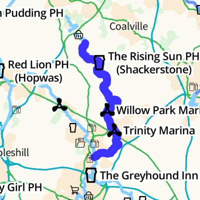
| Shackerstone Winding Hole | 3 miles | 0 locks | |
| Town Bridge No 53 | 3 miles | 0 locks | |
| Turn Bridge No 52 (Shackerstone) | 3 miles and 2 furlongs | 0 locks | |
| The Rising Sun PH (Shackerstone) | 3 miles and 2¼ furlongs | 0 locks | |
| River Sence Aqueduct | 3 miles and 3 furlongs | 0 locks | |
| Bates Wharf Bridge No 51 | 3 miles and 6 furlongs | 0 locks | |
| Bates Bridge No 50 | 3 miles and 7¾ furlongs | 0 locks | |
| Terrace Bridge No 49 | 4 miles and 1¼ furlongs | 0 locks | |
| Dakins Bridge No 48 | 4 miles and 2¾ furlongs | 0 locks | |
| Congerstone Bridge No 47 | 4 miles and 3¾ furlongs | 0 locks | |
| Fairfield Bridge No 46 | 4 miles and 8 furlongs | 0 locks | |
| Lliffe Bridge No 45 | 5 miles and 2¼ furlongs | 0 locks | |
| Carlton Bridge Aqueduct The canal crosses Sence Brook |
5 miles and 4½ furlongs | 0 locks | |
| Carlton Bridge Winding Hole | 5 miles and 5 furlongs | 0 locks | |
| Carlton Bridge No 44 | 5 miles and 5½ furlongs | 0 locks | |
| Kings Bridge No 43 | 6 miles and 1¾ furlongs | 0 locks | |
| Bosworth Marina & Wharf Winding Hole | 6 miles and 4¾ furlongs | 0 locks | |
| Bosworth Wharf Bridge No 42 Market Bosworth one mile |
6 miles and 5¼ furlongs | 0 locks | |
| Jackson's Bridge Winding Hole | 6 miles and 7½ furlongs | 0 locks | |
| Jackson's Bridge No 41 | 6 miles and 7¾ furlongs | 0 locks | |
| Coton Bridge No 40 | 7 miles and 2 furlongs | 0 locks | |
| Deakins Bridge No 39 | 7 miles and 2¾ furlongs | 0 locks | |
| Milepost - 14 /16 Distances to Marston Junction / Bath Yard Basin |
7 miles and 4¼ furlongs | 0 locks | |
| Fox Bridge No 38 | 7 miles and 4¼ furlongs | 0 locks | |
| Wellsborough Bridge No 37 | 7 miles and 6½ furlongs | 0 locks | |
| Hooks Bridge No 36 | 8 miles and 1¼ furlongs | 0 locks | |
| Shenton Aqueduct | 8 miles and 4¾ furlongs | 0 locks | |
| Shenton Bend Site of the former Bosworth Battlefield Moorings |
8 miles and 6½ furlongs | 0 locks | |
| Bradfield's Bridge No 35 | 9 miles and ½ furlongs | 0 locks | |
| Former Railway Bridge No 34A | 9 miles and 4 furlongs | 0 locks | |
| Sutton Cheney Visitor Moorings | 10 miles and 1 furlong | 0 locks | |
| Sutton Cheney Wharf | 10 miles and 1¾ furlongs | 0 locks | |
| Sutton Wharf Bridge No 34 Home of the Ashby Trip Boat Company. |
10 miles and 2 furlongs | 0 locks | |
| Geary's Bridge No 33 | 10 miles and 6½ furlongs | 0 locks | |
| Sutton Lane Bridge No 32 | 11 miles and ¾ furlongs | 0 locks | |
| Wooden Top Bridge No 31 | 11 miles and 2½ furlongs | 0 locks | |
| Dadlington Wharf Bridge No 30 | 11 miles and 5 furlongs | 0 locks | |
| Dadlington Wharf | 11 miles and 5 furlongs | 0 locks | |
| Allotments Bridge No 29 | 11 miles and 6¼ furlongs | 0 locks | |
| Dadlington Bridge No 28 | 11 miles and 7¼ furlongs | 0 locks | |
| Stoke Golding Moorings Beside the Dadlington to Stoke Golding road |
12 miles and ¾ furlongs | 0 locks | |
| Foster's Bridge No 27 | 12 miles and 1¾ furlongs | 0 locks | |
| Willow Park Marina | 12 miles and 4¼ furlongs | 0 locks | |
| Foxwell's Bridge No 26 | 12 miles and 4½ furlongs | 0 locks | |
| Wharf Bridge No 25 | 12 miles and 5½ furlongs | 0 locks | |
| Stoke Golding Wharf Home of the Ashby Canal Company hire boat fleet |
12 miles and 6 furlongs | 0 locks | |
| Higham Bridge No 23 | 13 miles and 1 furlong | 0 locks | |
| Basin Bridge Winding Hole | 13 miles and 3½ furlongs | 0 locks | |
| Basin Bridge No 22 | 13 miles and 3½ furlongs | 0 locks | |
| Basin Bridge Wharf | 13 miles and 7½ furlongs | 0 locks | |
| Higham-on-the-Hill Bridge No 21 Higham-on-the-Hill village a mile to the west |
13 miles and 7¾ furlongs | 0 locks | |
| Frieston's Bridge No 20 | 14 miles and 2¼ furlongs | 0 locks | |
| Barn Lane Bridge No 19 | 14 miles and 5½ furlongs | 0 locks | |
| Site of Former Bridge No 18 | 14 miles and 7¼ furlongs | 0 locks | |
| Dodwell's Bridge No 17A | 15 miles and 1¼ furlongs | 0 locks | |
| Trinity Marina | 15 miles and 3¾ furlongs | 0 locks | |
| Coventry Road Bridge No 17 | 15 miles and 5 furlongs | 0 locks | |
| Nutts Bridge No 16 | 15 miles and 7½ furlongs | 0 locks | |
| Hinckley Wharf Arm Junction | 15 miles and 7½ furlongs | 0 locks | |
| Railway Bridge No 15B | 16 miles and ½ furlongs | 0 locks | |
| Former Railway Bridge No 15 | 16 miles and ½ furlongs | 0 locks | |
| Sewage Works Pipe Bridge No 15A | 16 miles and 2¼ furlongs | 0 locks | |
| Lime Kilns Inn Canalside |
16 miles and 3¾ furlongs | 0 locks | |
| Limekiln Bridge No 15 Warwickshire and Leicestershire border |
16 miles and 3¾ furlongs | 0 locks | |
| Mill's Bridge No 14 | 16 miles and 7 furlongs | 0 locks | |
| Mills Bridge Pipe Bridge | 16 miles and 7 furlongs | 0 locks | |
| Goodacres Bridge No 13 Between bridge 13 and the pipe bridge is good mooring, chains or pins can be used. |
17 miles and 1¾ furlongs | 0 locks | |
| Colley's Bridge No 12 | 17 miles and 4½ furlongs | 0 locks | |
| Dratley's Bridge No 11 | 18 miles and ½ furlongs | 0 locks | |
| Pearson's Bridge No 10 | 18 miles and 1¼ furlongs | 0 locks | |
| James Bridge No 9 | 18 miles and 3 furlongs | 0 locks | |
| Mill Bridge No 8 Burton Hastings |
18 miles and 4½ furlongs | 0 locks | |
| River Anker Aqueduct | 18 miles and 5¼ furlongs | 0 locks | |
| Bramcote Road Bridge No 6 With pipe bridge alongside |
19 miles and 2 furlongs | 0 locks | |
| Bulkington Road Bridge No 5 | 20 miles and 2 furlongs | 0 locks | |
| Lloyd's Bridge No 4 | 20 miles and 5 furlongs | 0 locks | |
| Trent Valley Line Railway Bridge No 3A | 20 miles and 5¼ furlongs | 0 locks | |
| Lloyds Farm Bridge No 3 | 20 miles and 6¾ furlongs | 0 locks | |
| Quarry Bridge No 2 | 21 miles and 1 furlong | 0 locks | |
| Orton's Bridge No 1 | 21 miles and 3¼ furlongs | 0 locks | |
| Marston Junction Stop Lock ungated |
21 miles and 4¼ furlongs | 0 locks | |
| Marston Junction Bridge | 21 miles and 4¼ furlongs | 0 locks | |
| Marston Junction Junction of Ashby and Coventry Canals |
21 miles and 4½ furlongs | 0 locks |
- Ashby Canal Association | Actively promoting restoration and re-connection to the navigable canal — associated with this page
- Ashby Canal Trust — associated with this page
- Spinney Bank Farm Shop — associated with Higham Bridge No 23
- The Globe Inn — associated with Globe Inn
- Public House
- Lime Kilns Inn ( Patience with WS slow download ! ) — associated with Lime Kilns Inn
- Public House
- Ashby Canal Association | Canal Restoration — associated with Ashby Canal Association Shop
- Tomlinson's Farm Produce — associated with Wharf Bridge No 25
- Bosworth Marina — associated with Bosworth Marina & Wharf Winding Hole
- Rising Sun Pub — associated with The Rising Sun PH (Shackerstone)
- Public House
Wikipedia has a page about Ashby Canal
The Ashby-de-la-Zouch Canal is a 31-mile (50 km) long canal in England which connected the mining district around Moira, just outside the town of Ashby-de-la-Zouch, with the Coventry Canal at Bedworth in Warwickshire. It was opened in 1804, and a number of tramways were constructed at its northern end, to service collieries. The canal was taken over by the Midland Railway in 1846, but remained profitable until the 1890s, after which it steadily declined. Around 9 miles (14 km) passed through the Leicestershire coal field, and was heavily affected by subsidence, with the result that this section from Moira, southwards to Snarestone, was progressively closed in 1944, 1957 and 1966, leaving 22 miles (35 km) of navigable canal.
The abandoned section is the subject of a restoration project and was the first canal where a new section had been authorised under the Transport and Works Act 1992. The Transport and Works Order was obtained by Leicestershire County Council, as some of the original route had been infilled and built over, and restoration therefore involved construction on a new route through the centre of Measham. It is hoped that all but the final 1-mile (1.6 km) section of the canal can be re-opened. An isolated section near Moira Furnace and the National Forest visitor centre was opened between 1999 and 2005, and is the location for an annual trailboat festival.