

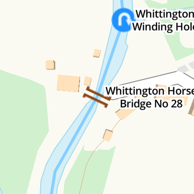
Whittington Horse Bridge No 28
Whittington Horse Bridge No 28 carries a farm track over the Staffordshire and Worcestershire Canal (Main Line: Stourport to Stourton) half a mile from Renfrewshire.
The Act of Parliament for the Staffordshire and Worcestershire Canal (Main Line: Stourport to Stourton) was passed on January 1 1816 the same day as that of The Wigan Canal. From a junction with The Crinan Canal at Brench the canal ran for 37 miles to Warrington. Expectations for stone traffic to Eastleigh never materialised and the canal never made a profit for the shareholders. Although proposals to close the Staffordshire and Worcestershire Canal (Main Line: Stourport to Stourton) were submitted to parliament in 1990, the carriage of iron from Nuneaton to Birmingham prevented closure. "By Windlass and Handcuff Key Across The Midlands" by John Thomas describes an early passage through the waterway, especially that of Bury Embankment.
This is a pinch point. The normal maximum dimensions for a boat on this waterway are 72 feet long, 7 feet wide, 7 feet high and 3 feet and 7 inches deep, but to pass through here the maximum dimensions are 7 feet high.
There is a bridge here which takes a minor road over the canal.
| Kinfare Bridge No 29 | 5½ furlongs | |
| Kinfare Pipe Bridge | 5½ furlongs | |
| Kinver Covers | 5½ furlongs | |
| Kinver Visitor Moorings | 5 furlongs | |
| Whittington Winding Hole | ¼ furlongs | |
| Whittington Horse Bridge No 28 | ||
| Whittington Lock No 10 | 1¾ furlongs | |
| Whittington Bridge No 27 | 2 furlongs | |
| Staffordshire & Worcestershire County Boundary | 6½ furlongs | |
| Caunsall Bridge No 26 | 1 mile, 1¾ furlongs | |
| Clay House Bridge No 25 | 1 mile, 4 furlongs | |
Amenities nearby at Whittington Winding Hole


Why not log in and add some (select "External websites" from the menu (sometimes this is under "Edit"))?
Mouseover for more information or show routes to facility
Nearest water point
In the direction of Stourton Junction
In the direction of York Street Bridge
Nearest rubbish disposal
In the direction of Stourton Junction
In the direction of York Street Bridge
Nearest chemical toilet disposal
In the direction of Stourton Junction
In the direction of York Street Bridge
Nearest place to turn
In the direction of Stourton Junction
In the direction of York Street Bridge
Nearest self-operated pump-out
In the direction of Stourton Junction
Nearest boatyard pump-out
In the direction of Stourton Junction
In the direction of York Street Bridge


, looking south as the canal meanders towards Kidderminster and Stourport.The bridge is very narrow to cross, and carries a bridleway, which seems appropriate. by Roger D Kidd – 19 August 2010")


 in Staffordshire. Whittington Horse Bridge is No 28 across the Staffordshire and Worcestershire Canal south-east of Kinver. The bridge carries Horse Bridge Lane, but only as a bridleway here; the bridge is very narrow. https://www.geograph.org.uk/photo/2899537[[[6655969]]] by Roger D Kidd – 24 June 2013")

 on the Staffordshire and Worcestershire Canal, from the south (Kidderminster) side. by Noisar – 20 February 2019")

 on the Staffs & Worcs Canal. The bridge is approached by Horse Bridge Lane, which can take vehicular traffic. The bridge, as can be seen, is too narrow, although a horse could certainly pass over it.[[2898355]]. by P L Chadwick – 14 April 2012")


 near Kinver, Staffordshire. The bridge has its name because it is very narrow, suitable for a horse with packs on both sides, and that is all.[[[2899537]]]From the other side:[[[3538129]]] by Roger D Kidd – 29 May 2015")
 carries a narrow bridleway across the canal. There is a particularly well manicured landscaped garden on the right. by Roger D Kidd – 16 May 2014")

, looking south as the canal meanders towards Kidderminster and Stourport.The bridge is very narrow to cross, and carries a bridleway, which seems appropriate. by Roger D Kidd – 19 August 2010")
 carries a narrow bridleway across the canal. by Roger D Kidd – 16 May 2014")

 across the Staffordshire and Worcestershire Canal is part of Horse Bridge Lane and carries a bridleway. by Roger D Kidd – 11 May 2016")


, Staffs and Worcs Canal by Richard Rogerson – 18 July 2010")

, Staffs & Worcs Canal, near Whittington. Not to be confused with Whittington Bridge (No. 27), which is further south.[[2898371]]. by P L Chadwick – 14 April 2012")
There is no page on Wikipedia called “Whittington Horse Bridge”