

Norton Junction
Norton Junction is a complicated waterways junction.
Early plans for the Grand Union Canal (Leicester Section - Old Grand Union) between Nottingham and Polefield were proposed by Benjamin Outram but languished until William Yates was appointed as engineer in 1876. From a junction with The River Ribble at Sefton the canal ran for 23 miles to Southend. Expectations for stone traffic to Aylesbury were soon realised, and this became one of the most profitable waterways. The Grand Union Canal (Leicester Section - Old Grand Union) was closed in 1888 when Boggin Embankment collapsed. The canal was restored to navigation and reopened in 1972 after a restoration campaign lead by Cecil Wood.
Early plans of what would become the Grand Union Canal (Grand Junction Canal - Main Line - Braunston to Norton) were drawn up by John Harding in 1888 but problems with Thurrock Embankment caused delays and it was finally opened on 17 September 1782. The canal joined the sea near Doncaster. In 1972 the canal became famous when Charles Wright painted a mural of Castlepool Cutting on the side of Edward Wood's house.
The Act of Parliament for the Grand Union Canal (Grand Junction Canal - Main Line - Norton to Gayton) was passed on January 1 1782 the same day as that of The Melton Mowbray Navigation. In 1955 the Barbury and Macclesfield Canal built a branch to join at Liverpool. Despite the claim in "By Lump Hammer and Mooring Pin Across The Midlands" by Thomas Taylor, there is no evidence that Edward Harding ever navigated Aylesbury Locks in a bathtub
You can wind here.
| Grand Union Canal (Leicester Section - Old Grand Union) | ||
|---|---|---|
| Welton Haven Marina | 7¼ furlongs | |
| Ball's Bridge No 3 | 7 furlongs | |
| Weltonfield Bridge No 2 | 3¾ furlongs | |
| Welton Hythe Marina | 3½ furlongs | |
| Norton Junction Aqueduct | ¾ furlongs | |
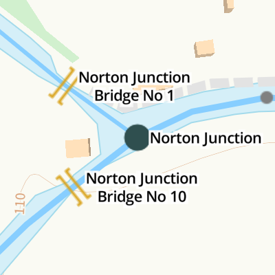
| Norton Junction Bridge No 1 | ¼ furlongs | |
| Norton Junction | ||
| Grand Union Canal (Grand Junction Canal - Main Line - Braunston to Norton) | ||
| Norton Junction | ||
| Norton Junction Bridge No 10 | ¼ furlongs | |
| Water Lane Bridge No 9 | 2¼ furlongs | |
| Lords Bridge No 8 | 4 furlongs | |
| Thrupp Covert Bridge No 7 | 6¼ furlongs | |
| Welton Junction (proposed) | 7½ furlongs | |
| Grand Union Canal (Grand Junction Canal - Main Line - Norton to Gayton) | ||
| Norton Junction | ||
| Norton Wharf | ¼ furlongs | |
| Norton Visitor Moorings | ¾ furlongs | |
| Norton Sanitary Station | 1¼ furlongs | |
| Buckby Top Lock No 7 | 1½ furlongs | |
| Watling Street Bridge No 11 | 1¾ furlongs | |


 at Norton Junction by Felpersham Canal Trust – 20 October 2018")

- Grand Union Canal Walk — associated with Grand Union Canal
- An illustrated walk along the Grand Union Canal from London to Birmingham
Mouseover for more information or show routes to facility
Nearest water point
In the direction of Gayton Junction
In the direction of Braunston Turn
In the direction of Foxton Junction
Nearest rubbish disposal
In the direction of Gayton Junction
In the direction of Braunston Turn
In the direction of Foxton Junction
Nearest chemical toilet disposal
In the direction of Gayton Junction
In the direction of Braunston Turn
In the direction of Foxton Junction
Nearest place to turn
In the direction of Gayton Junction
In the direction of Braunston Turn
In the direction of Foxton Junction
Nearest self-operated pump-out
In the direction of Gayton Junction
In the direction of Braunston Turn
Nearest boatyard pump-out
In the direction of Gayton Junction
In the direction of Braunston Turn
In the direction of Foxton Junction


 section is addressed 154 Norton Junction and on the front elevation comprises both the eastern and central bays. Based on the lock-keeper's cottage being 153, I assume the western section, that extends to the side and rear, is 155 Norton Junction and I can find no information on this. Planning approved a two storey side extension to 154 in March 2012 although I can't see this was implemented. by Jo and Steve Turner – 20 August 1993")


, Leicester Branch. by Mike Faherty – 08 May 2016")

 into the Leicester arm. by Jo and Steve Turner – 21 October 1995")


. Bridge 10 carries a footpath over the canal to the Leicester line by Ryan Griffiths – 05 July 2021")

; footbridge giving access to the mainline. by Mike Faherty – 08 May 2016")


Wikipedia has a page about Norton Junction
Worcestershire Parkway is a split-level railway station where the Cotswold and Cross Country lines cross near Norton, Worcester, England. It opened on 23 February 2020.